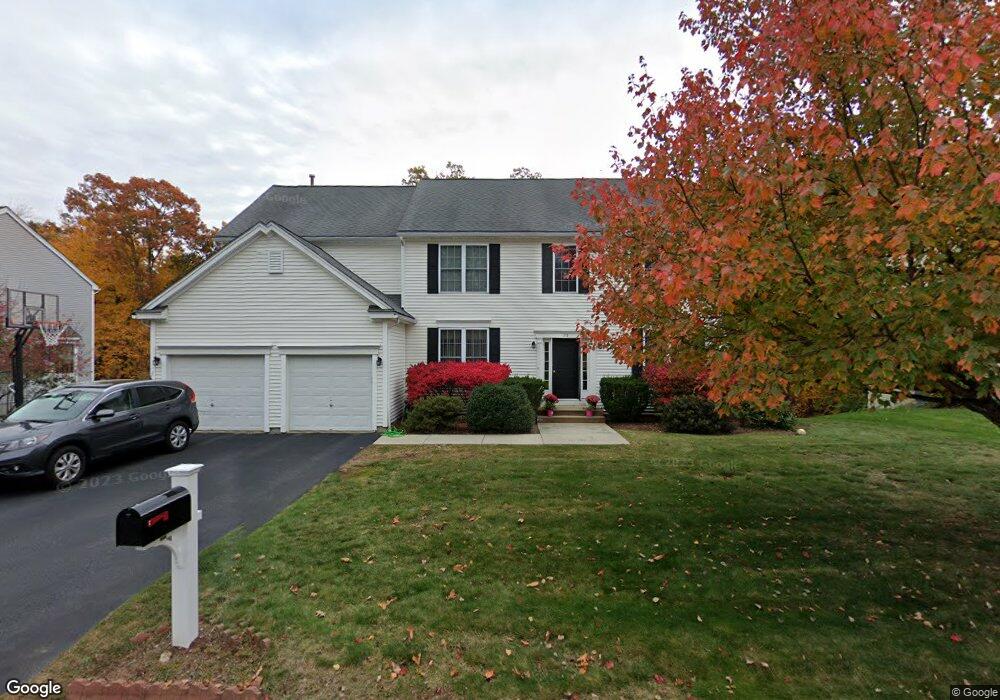
28 Independence Ln Ashland, MA 01721
Estimated Value: $1,007,037 - $1,240,000
4
Beds
3
Baths
2,906
Sq Ft
$394/Sq Ft
Est. Value
About This Home
This home is located at 28 Independence Ln, Ashland, MA 01721 and is currently estimated at $1,146,009, approximately $394 per square foot. 28 Independence Ln is a home located in Middlesex County with nearby schools including William Pittaway Elementary School, David Mindess Elementary School, and Henry E. Warren Elementary School.
Create a Home Valuation Report for This Property
The Home Valuation Report is an in-depth analysis detailing your home's value as well as a comparison with similar homes in the area
Home Values in the Area
Average Home Value in this Area
Tax History Compared to Growth
Tax History
| Year | Tax Paid | Tax Assessment Tax Assessment Total Assessment is a certain percentage of the fair market value that is determined by local assessors to be the total taxable value of land and additions on the property. | Land | Improvement |
|---|---|---|---|---|
| 2025 | $12,070 | $945,200 | $273,500 | $671,700 |
| 2024 | $11,499 | $868,500 | $273,500 | $595,000 |
| 2023 | $10,573 | $767,800 | $261,100 | $506,700 |
| 2022 | $10,652 | $670,800 | $235,300 | $435,500 |
| 2021 | $10,171 | $638,500 | $235,300 | $403,200 |
| 2020 | $9,984 | $617,800 | $238,800 | $379,000 |
| 2019 | $9,701 | $595,900 | $238,800 | $357,100 |
| 2018 | $9,630 | $579,800 | $236,800 | $343,000 |
| 2017 | $9,446 | $565,600 | $236,800 | $328,800 |
| 2016 | $9,209 | $541,700 | $236,800 | $304,900 |
| 2015 | $8,935 | $516,500 | $223,600 | $292,900 |
| 2014 | $8,704 | $500,500 | $208,700 | $291,800 |
Source: Public Records
Map
Nearby Homes
- 0 Oak St
- 23 Stonebrook Ct Unit 11
- 22 Irene Cir
- 9 Wentworth Dr
- 0 Oregon Rd
- 41 Darlene Dr
- 2 High Ridge Rd
- 0 Cordaville Rd
- 9 Cherry St
- 3 Johnson St
- 8 Lorenzo Dr
- 216 Boston Rd
- 39 Woodbury Rd
- 1 Blueberry Ln
- 7 John St
- 21 William Onthank Ln
- 38 William Onthank Ln
- 40 William Onthank Ln
- 7 Rockpoint Rd
- 1 Carriage Hill Cir Unit 1
- 24 Independence Ln
- 36 Independence Ln
- 27 Independence Ln
- 11 Whippoorwill Ln
- 20 Independence Ln
- 23 Independence Ln
- 14 Whippoorwill Ln
- 35 Independence Ln
- 40 Independence Ln
- 17 Independence Ln
- 39 Independence Ln
- 7 Whippoorwill Ln
- 16 Independence Ln
- 10 Whippoorwill Ln
- 15 Independence Ln
- 44 Independence Ln
- 43 Independence Ln
- 115 Independence Ln
- 3 Whippoorwill Ln
- 11 Independence Ln