
Seller's Agent in 2025
Shelly Cumpstone
Coldwell Banker Realty
(860) 391-2747
15 in this area
135 Total Sales
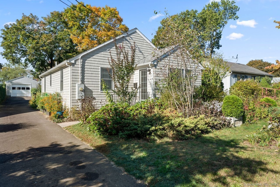
Welcome to this beautifully remodeled ranch-style home that exudes the cozy feel of a beach cottage. Nestled in a quiet cul-de-sac neighborhood in the shoreline town of Clinton and completely renovated and expanded between 2011 and 2013, this 975 sq. ft. residence showcases exceptional craftsmanship and attention to detail throughout. Every system and surface was renewed-windows, doors, roof, siding, mechanicals, and fixtures-while preserving the mid-century character that gives the home its charm, including arched doorways and gleaming hardwood floors. In addition to the renovation of the existing home, additions to the front and rear of the home were completed. The front of the home, expanded to create a mudroom-like entryway complete with beadboard paneling, large closet and coat hooks, is used as an office. A light-filled four-season sunroom was added to the rear and is perfect for dining or relaxing. The two sets of sliders open to a private patio surrounded by thoughtfully designed, pollinator-friendly gardens that surround the home. There is a detached garage and paved driveway for your convenience. With low costs for maintenance and utilities, this home is easy on your wallet too! Whether you're seeking a year-round home, a rental investment or a coastal retreat, you'll love this peaceful setting that's just minutes to beaches, marinas, town center, restaurants, commuter rail station, and I-95 ~~ the perfect blend of coastal charm, comfort, and convenience.
Last Agent to Sell the Property
Coldwell Banker Realty Brokerage Phone: (860) 391-2747 License #RES.0792433 Listed on: 10/07/2025
| Date | Type | Sale Price | Title Company |
|---|---|---|---|
| Warranty Deed | $425,000 | -- | |
| Quit Claim Deed | -- | -- | |
| Quit Claim Deed | -- | -- | |
| Warranty Deed | $245,000 | -- | |
| Warranty Deed | $245,000 | -- | |
| Warranty Deed | $175,000 | -- | |
| Warranty Deed | $175,000 | -- | |
| Warranty Deed | $95,000 | -- | |
| Warranty Deed | $95,000 | -- |
| Date | Status | Loan Amount | Loan Type |
|---|---|---|---|
| Open | $340,000 | New Conventional | |
| Previous Owner | $20,000 | No Value Available | |
| Previous Owner | $244,500 | Purchase Money Mortgage |
| Date | Event | Price | List to Sale | Price per Sq Ft |
|---|---|---|---|---|
| 11/21/2025 11/21/25 | Sold | $425,000 | -7.6% | $436 / Sq Ft |
| 11/03/2025 11/03/25 | Pending | -- | -- | -- |
| 10/10/2025 10/10/25 | For Sale | $460,000 | -- | $472 / Sq Ft |
| Year | Tax Paid | Tax Assessment Tax Assessment Total Assessment is a certain percentage of the fair market value that is determined by local assessors to be the total taxable value of land and additions on the property. | Land | Improvement |
|---|---|---|---|---|
| 2025 | $3,914 | $125,700 | $45,600 | $80,100 |
| 2024 | $3,804 | $125,700 | $45,600 | $80,100 |
| 2023 | $3,750 | $125,700 | $45,600 | $80,100 |
| 2022 | $3,750 | $125,700 | $45,600 | $80,100 |
| 2021 | $3,687 | $123,600 | $48,000 | $75,600 |
| 2020 | $3,863 | $123,600 | $48,000 | $75,600 |
| 2019 | $3,863 | $123,600 | $48,000 | $75,600 |
| 2018 | $3,775 | $123,600 | $48,000 | $75,600 |
| 2017 | $3,697 | $123,600 | $48,000 | $75,600 |
| 2016 | $3,355 | $123,600 | $48,000 | $75,600 |
| 2015 | $3,408 | $127,300 | $50,100 | $77,200 |
| 2014 | $3,344 | $127,300 | $50,100 | $77,200 |
Seller's Agent in 2025
Shelly Cumpstone
Coldwell Banker Realty
(860) 391-2747
15 in this area
135 Total Sales
Buyer's Agent in 2025
Patty Gallagher
Coldwell Banker Realty
(860) 227-9365
7 in this area
25 Total Sales
Source: SmartMLS
MLS Number: 24131597
APN: CLIN-000045-000013-000036
Disclaimer: Certain information contained herein is derived from information provided by parties other than Homes.com. All information provided is deemed reliable, but is not guaranteed to be accurate and should be independently verified.
![]() IDX information is provided exclusively for personal, non-commercial use, and may not be used for any purpose other than to identify prospective properties consumers may be interested in purchasing. Information is deemed reliable but not guaranteed.
IDX information is provided exclusively for personal, non-commercial use, and may not be used for any purpose other than to identify prospective properties consumers may be interested in purchasing. Information is deemed reliable but not guaranteed.
Ask me questions while you tour the home.