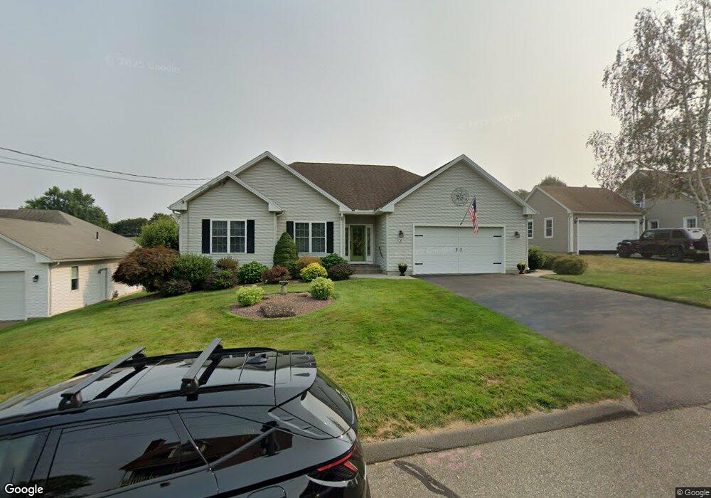
28 Mayer Dr Holyoke, MA 01040
Estimated Value: $437,000 - $477,000
3
Beds
2
Baths
1,757
Sq Ft
$256/Sq Ft
Est. Value
About This Home
This home is located at 28 Mayer Dr, Holyoke, MA 01040 and is currently estimated at $450,515, approximately $256 per square foot. 28 Mayer Dr is a home located in Hampden County with nearby schools including Lt. Elmer J. McMahon Elementary School, Lt. Clayre Sullivan Elementary School, and Holyoke High School.
Ownership History
Date
Name
Owned For
Owner Type
Purchase Details
Closed on
Oct 21, 2011
Sold by
Greaney James J and Greaney Karen A
Bought by
Stone Jeffrey C and Accomando Thomas M
Current Estimated Value
Home Financials for this Owner
Home Financials are based on the most recent Mortgage that was taken out on this home.
Original Mortgage
$210,000
Outstanding Balance
$19,914
Interest Rate
4.15%
Mortgage Type
Purchase Money Mortgage
Estimated Equity
$430,601
Purchase Details
Closed on
Jul 1, 2005
Sold by
Home Inmprovemen Asso
Bought by
Greaney James J and Greaney Karen A
Home Financials for this Owner
Home Financials are based on the most recent Mortgage that was taken out on this home.
Original Mortgage
$271,000
Interest Rate
5.73%
Mortgage Type
Purchase Money Mortgage
Purchase Details
Closed on
Feb 4, 2005
Sold by
Tabin Alan J and Cauley Edward J
Bought by
Home Improvem Assoc Ll
Create a Home Valuation Report for This Property
The Home Valuation Report is an in-depth analysis detailing your home's value as well as a comparison with similar homes in the area
Home Values in the Area
Average Home Value in this Area
Purchase History
| Date | Buyer | Sale Price | Title Company |
|---|---|---|---|
| Stone Jeffrey C | $295,000 | -- | |
| Greaney James J | $318,840 | -- | |
| Home Improvem Assoc Ll | $59,285 | -- |
Source: Public Records
Mortgage History
| Date | Status | Borrower | Loan Amount |
|---|---|---|---|
| Open | Stone Jeffrey C | $210,000 | |
| Previous Owner | Greaney James J | $271,000 |
Source: Public Records
Tax History
| Year | Tax Paid | Tax Assessment Tax Assessment Total Assessment is a certain percentage of the fair market value that is determined by local assessors to be the total taxable value of land and additions on the property. | Land | Improvement |
|---|---|---|---|---|
| 2025 | $7,462 | $427,400 | $71,000 | $356,400 |
| 2024 | $6,972 | $367,900 | $67,700 | $300,200 |
| 2023 | $6,643 | $354,100 | $67,700 | $286,400 |
| 2022 | $6,310 | $327,600 | $67,700 | $259,900 |
| 2021 | $6,037 | $313,300 | $65,100 | $248,200 |
| 2020 | $4,503 | $299,200 | $65,100 | $234,100 |
| 2019 | $3,091 | $288,100 | $65,100 | $223,000 |
| 2018 | $3,836 | $276,500 | $65,100 | $211,400 |
| 2017 | $3,510 | $276,500 | $65,100 | $211,400 |
| 2016 | $5,212 | $272,600 | $67,000 | $205,600 |
| 2015 | $5,190 | $272,600 | $67,000 | $205,600 |
Source: Public Records
Map
Nearby Homes
- 287 Whitney Ave
- 53 Farnum Dr Unit 53
- 94 Vermont St
- 337 Westfield Rd
- 286 Westfield Rd
- 147 Sheehan Dr
- 350 Homestead Ave
- 89-111 Whitney Ave
- 958 Main St
- 934 Main St
- 25-27 Elmwood Ave
- 46 Maplewood Ave
- 2027-2029 Northampton St
- 10 View St
- 15 Maple Crest Cir Unit D
- 133-135 Brown Ave
- 36 Daley St
- 343 Chicopee St Unit 14
- 39 State St
- 551 Lafleur Dr
Your Personal Tour Guide
Ask me questions while you tour the home.