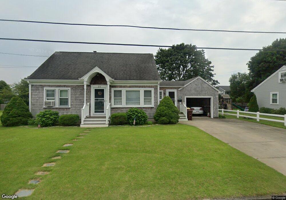
28 Meadow Ln Acushnet, MA 02743
Coury Heights NeighborhoodEstimated Value: $442,000 - $485,000
--
Bed
1
Bath
1,050
Sq Ft
$439/Sq Ft
Est. Value
About This Home
This home is located at 28 Meadow Ln, Acushnet, MA 02743 and is currently estimated at $460,678, approximately $438 per square foot. 28 Meadow Ln is a home located in Bristol County with nearby schools including Acushnet Elementary School, Albert F Ford Middle School, and All Saints Catholic School.
Ownership History
Date
Name
Owned For
Owner Type
Purchase Details
Closed on
Mar 14, 2007
Sold by
Amaral Nancy
Bought by
Amaral Nancy and Williams Sharon
Current Estimated Value
Purchase Details
Closed on
Jan 27, 1998
Sold by
Raphael Paul and Raphael Michelle Lee
Bought by
Amaral Nancy
Home Financials for this Owner
Home Financials are based on the most recent Mortgage that was taken out on this home.
Original Mortgage
$69,900
Interest Rate
7.11%
Mortgage Type
Purchase Money Mortgage
Purchase Details
Closed on
Oct 13, 1993
Sold by
Raphael Paul
Bought by
Raphael Paul and Gonsalves Michelle
Home Financials for this Owner
Home Financials are based on the most recent Mortgage that was taken out on this home.
Original Mortgage
$65,000
Interest Rate
6.87%
Mortgage Type
Purchase Money Mortgage
Create a Home Valuation Report for This Property
The Home Valuation Report is an in-depth analysis detailing your home's value as well as a comparison with similar homes in the area
Home Values in the Area
Average Home Value in this Area
Purchase History
| Date | Buyer | Sale Price | Title Company |
|---|---|---|---|
| Amaral Nancy | -- | -- | |
| Amaral Nancy | $119,900 | -- | |
| Raphael Paul | $81,250 | -- |
Source: Public Records
Mortgage History
| Date | Status | Borrower | Loan Amount |
|---|---|---|---|
| Previous Owner | Raphael Paul | $69,900 | |
| Previous Owner | Raphael Paul | $65,000 | |
| Previous Owner | Raphael Paul | $25,000 | |
| Previous Owner | Raphael Paul | $7,154 |
Source: Public Records
Tax History Compared to Growth
Tax History
| Year | Tax Paid | Tax Assessment Tax Assessment Total Assessment is a certain percentage of the fair market value that is determined by local assessors to be the total taxable value of land and additions on the property. | Land | Improvement |
|---|---|---|---|---|
| 2025 | $43 | $394,500 | $121,500 | $273,000 |
| 2024 | $4,072 | $356,900 | $115,100 | $241,800 |
| 2023 | $4,106 | $342,200 | $104,400 | $237,800 |
| 2022 | $4,050 | $305,200 | $98,000 | $207,200 |
| 2021 | $3,763 | $272,100 | $98,000 | $174,100 |
| 2020 | $3,704 | $265,700 | $91,600 | $174,100 |
| 2019 | $3,514 | $247,800 | $87,400 | $160,400 |
| 2018 | $3,396 | $235,500 | $87,400 | $148,100 |
| 2017 | $3,382 | $234,200 | $87,400 | $146,800 |
| 2016 | $3,403 | $234,200 | $87,400 | $146,800 |
| 2015 | $3,114 | $218,100 | $87,400 | $130,700 |
Source: Public Records
Map
Nearby Homes
- 6 Middlefield Place
- 65 Armsby St
- 9 Middlefield Place
- 187 Tarkiln Hill Rd
- 6 Illinois St
- 4 Tisbury St
- 263 Hersom St
- 506 Hawes St
- 0 Church Dutton & Chaffee Unit 73371719
- 957 Glen St
- 11 Saucier St
- 27 Jean St
- 1044 Victoria St Unit B-29
- 52 Pershing Ave
- 400 Oliver St
- 203 S Main St
- 398 Brockton St
- 11 Moynan St
- 683 Church St
- 868 Phillips Rd