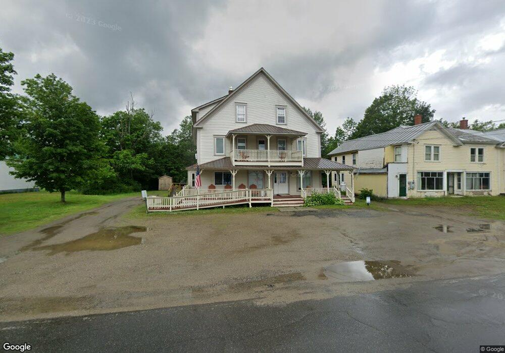
28 S Main St Andover, ME 04216
Estimated Value: $195,000 - $358,032
7
Beds
5
Baths
2,772
Sq Ft
$99/Sq Ft
Est. Value
About This Home
This home is located at 28 S Main St, Andover, ME 04216 and is currently estimated at $273,508, approximately $98 per square foot. 28 S Main St is a home located in Oxford County with nearby schools including Telstar Middle School and Telstar High School.
Ownership History
Date
Name
Owned For
Owner Type
Purchase Details
Closed on
Jun 3, 2014
Sold by
Douglas L Turcotte Ret
Bought by
Smith Walter J and Smith Melissa M
Current Estimated Value
Home Financials for this Owner
Home Financials are based on the most recent Mortgage that was taken out on this home.
Original Mortgage
$140,000
Outstanding Balance
$106,105
Interest Rate
4.26%
Mortgage Type
Purchase Money Mortgage
Estimated Equity
$167,403
Create a Home Valuation Report for This Property
The Home Valuation Report is an in-depth analysis detailing your home's value as well as a comparison with similar homes in the area
Home Values in the Area
Average Home Value in this Area
Purchase History
| Date | Buyer | Sale Price | Title Company |
|---|---|---|---|
| Smith Walter J | $140,000 | -- |
Source: Public Records
Mortgage History
| Date | Status | Borrower | Loan Amount |
|---|---|---|---|
| Open | Smith Walter J | $140,000 |
Source: Public Records
Tax History Compared to Growth
Tax History
| Year | Tax Paid | Tax Assessment Tax Assessment Total Assessment is a certain percentage of the fair market value that is determined by local assessors to be the total taxable value of land and additions on the property. | Land | Improvement |
|---|---|---|---|---|
| 2025 | $3,763 | $173,400 | $24,436 | $148,964 |
| 2024 | $3,165 | $173,400 | $24,436 | $148,964 |
| 2023 | $2,688 | $173,400 | $24,436 | $148,964 |
| 2022 | $2,584 | $173,400 | $24,436 | $148,964 |
| 2021 | $2,428 | $173,400 | $24,436 | $148,964 |
| 2020 | $2,341 | $173,400 | $24,436 | $148,964 |
| 2019 | $2,601 | $173,400 | $24,436 | $148,964 |
| 2018 | $2,722 | $173,400 | $24,436 | $148,964 |
| 2017 | $3,233 | $141,813 | $12,450 | $129,363 |
| 2016 | $3,496 | $141,813 | $12,450 | $129,363 |
| 2015 | $2,780 | $141,813 | $12,450 | $129,363 |
| 2014 | $2,212 | $141,813 | $12,450 | $129,363 |
| 2013 | $2,056 | $141,813 | $12,450 | $129,363 |
Source: Public Records
Map
Nearby Homes
- 4 Nevel Rd
- 10 S Arm Rd
- Lot 39 Sawyer Notch Rd
- 577 E Andover Rd
- 91 Airport Rd
- Lot 045 Sawyer Notch Rd
- 130 Farmers Hill Rd
- 1077 S Main St
- 225 Main St
- 24 Dual Cove Point Rd
- 0 Garland Pond Rd Unit 24022621
- 0 Garland Pond Rd Unit 24427785
- 0 Garland Pond Rd Unit 23794839
- Lot 22 Roxbury Notch Rd
- Lot 27-001 Coburn Brook Rd
- 108 Coburn Brook Rd
- 14 Puzzle Mountain Rd
- Map 402 Lot 7 Rd
- Map 402 Lot 9
- Map 402 Lot 3
- 18 S Main St
- Lot 12 S Main St
- 48 S South Main St
- 0 Off South Main St Unit 1064581
- 1 S Main St
- 3 Skyline Dr
- 3 Franklin Way
- 0 N Main St Unit 619811
- 0 N Main St Unit 541521
- 0 N Main St Unit 260432
- 0 N Main St Unit 619801
- 0 N Main St Unit 343821
- 0 N Main St Unit 260663
- 0 N Main St Unit 303865
- 0 N Main St Unit 1029523
- 0 Route 120 Unit 785765
- 0 Route 120 Unit 195657
- 0 Route 120 Unit 1315230
- 33 Newton St
- 28 Newton St