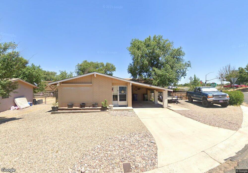
28 Thompson Dr Prescott, AZ 86305
Estimated Value: $371,000 - $455,000
2
Beds
2
Baths
1,235
Sq Ft
$325/Sq Ft
Est. Value
About This Home
This home is located at 28 Thompson Dr, Prescott, AZ 86305 and is currently estimated at $401,253, approximately $324 per square foot. 28 Thompson Dr is a home located in Yavapai County with nearby schools including Granite Mountain Middle School, Abia Judd Elementary School, and Prescott Mile High Middle School.
Ownership History
Date
Name
Owned For
Owner Type
Purchase Details
Closed on
Apr 6, 2010
Sold by
Yowell K C M
Bought by
Cutlip Thomas and Cutlip Rebecca
Current Estimated Value
Purchase Details
Closed on
Oct 28, 2009
Sold by
Yowell William G and Yowell Toni L
Bought by
Yowell K C M
Purchase Details
Closed on
Mar 7, 2003
Sold by
Yowell K C M
Bought by
Yowell K C M and Yowell William G
Purchase Details
Closed on
Oct 9, 1997
Sold by
Yowell Stephanie L
Bought by
Yowell Kc M
Purchase Details
Closed on
Nov 21, 1994
Sold by
Meyers Cora L and Ruhnke Esther
Bought by
Yowell Kc M and Yowell Stephanie L
Home Financials for this Owner
Home Financials are based on the most recent Mortgage that was taken out on this home.
Original Mortgage
$64,000
Interest Rate
9.08%
Create a Home Valuation Report for This Property
The Home Valuation Report is an in-depth analysis detailing your home's value as well as a comparison with similar homes in the area
Purchase History
| Date | Buyer | Sale Price | Title Company |
|---|---|---|---|
| Cutlip Thomas | $90,000 | Yavapai Title Agency Inc | |
| Yowell K C M | -- | None Available | |
| Yowell K C M | -- | Capital Title Agency | |
| Yowell Kc M | -- | -- | |
| Yowell Kc M | $80,000 | Transamerica Title Ins Co |
Source: Public Records
Mortgage History
| Date | Status | Borrower | Loan Amount |
|---|---|---|---|
| Previous Owner | Yowell Kc M | $64,000 |
Source: Public Records
Tax History
| Year | Tax Paid | Tax Assessment Tax Assessment Total Assessment is a certain percentage of the fair market value that is determined by local assessors to be the total taxable value of land and additions on the property. | Land | Improvement |
|---|---|---|---|---|
| 2026 | $1,110 | $26,428 | -- | -- |
| 2024 | $886 | $26,971 | -- | -- |
| 2023 | $886 | $22,884 | $5,550 | $17,334 |
| 2022 | $874 | $19,566 | $4,475 | $15,091 |
| 2021 | $937 | $18,601 | $4,130 | $14,471 |
| 2020 | $942 | $0 | $0 | $0 |
| 2019 | $935 | $0 | $0 | $0 |
| 2018 | $893 | $0 | $0 | $0 |
| 2017 | $861 | $0 | $0 | $0 |
| 2016 | $857 | $0 | $0 | $0 |
| 2015 | -- | $0 | $0 | $0 |
| 2014 | -- | $0 | $0 | $0 |
Source: Public Records
Map
Nearby Homes
- 6140 Crista Lynn Place Unit 15
- 6155 Crista Lynn Place Unit 5
- 1372 Towhee Trail
- 1365 Starling St
- 12 Bar Heart Dr
- 6263 Harvest Moon Ave
- 6256 Harvest Moon Ave
- 6877 Claret Dr
- 2 Walking Diamond Dr
- 3 Walking Diamond Dr
- 7028 Corral Ct
- 6905 Sienna Place
- 1603 Arrowleaf Ln
- 7037 Wallflower Way
- 7041 Wallflower Way
- 7019 Sterling Ln
- 7034 Wallflower Way
- 7049 Wallflower Way
- 7023 Sterling Ln
- 7091 Turquoise St
- 10 Antelope Dr Unit 14
- 27 Thompson Dr
- 2 Antelope Dr Unit 31
- 26 Thompson Dr
- 16 Antelope Dr
- 0 N Antelope Meadows Dr Unit 5725850
- 00 Antelope Dr Unit 30
- 0 N Antelope Meadows Dr Unit 31 5464983
- 0 N Antelope Meadows Dr Unit 2079991
- 0 N Antelope Meadows Dr Unit 2079988
- 0 N Antelope Meadows Dr Unit 2087930
- 0 N Antelope Meadows Dr Unit 124625
- 0 N Antelope Meadows Dr Unit PAR906017
- 0 N Antelope Meadows Dr Unit PAR906473
- 0 N Antelope Meadows Dr Unit PAR906475
- 0 N Antelope Meadows Dr Unit PAR903760
- 0 N Antelope Meadows Dr Unit PAR917008
- 0 N Antelope Meadows Dr Unit PAR917568
- 0 N Antelope Meadows Dr Unit PAR913650
- 0 N Antelope Meadows Dr Unit PAR913465
Your Personal Tour Guide
Ask me questions while you tour the home.