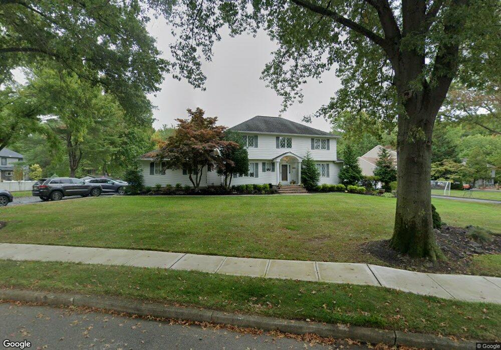
28 Ueland Rd Red Bank, NJ 07701
New Monmouth NeighborhoodEstimated Value: $1,097,000 - $1,192,000
4
Beds
3
Baths
2,422
Sq Ft
$473/Sq Ft
Est. Value
About This Home
This home is located at 28 Ueland Rd, Red Bank, NJ 07701 and is currently estimated at $1,146,516, approximately $473 per square foot. 28 Ueland Rd is a home located in Monmouth County with nearby schools including Nut Swamp Elementary School, Thompson Middle School, and Middletown - South High School.
Ownership History
Date
Name
Owned For
Owner Type
Purchase Details
Closed on
May 16, 2001
Sold by
Tornquist Gary
Bought by
Despirito Philip and Despirito Kathleen
Current Estimated Value
Home Financials for this Owner
Home Financials are based on the most recent Mortgage that was taken out on this home.
Original Mortgage
$360,000
Outstanding Balance
$134,921
Interest Rate
7.08%
Estimated Equity
$1,011,595
Purchase Details
Closed on
Mar 12, 1999
Sold by
Ivie Mark
Bought by
Tornquist Gary and Tornquist Jennifer
Home Financials for this Owner
Home Financials are based on the most recent Mortgage that was taken out on this home.
Original Mortgage
$239,900
Interest Rate
7.54%
Create a Home Valuation Report for This Property
The Home Valuation Report is an in-depth analysis detailing your home's value as well as a comparison with similar homes in the area
Home Values in the Area
Average Home Value in this Area
Purchase History
| Date | Buyer | Sale Price | Title Company |
|---|---|---|---|
| Despirito Philip | $450,000 | -- | |
| Tornquist Gary | $314,500 | -- |
Source: Public Records
Mortgage History
| Date | Status | Borrower | Loan Amount |
|---|---|---|---|
| Open | Despirito Philip | $360,000 | |
| Previous Owner | Tornquist Gary | $239,900 |
Source: Public Records
Tax History Compared to Growth
Tax History
| Year | Tax Paid | Tax Assessment Tax Assessment Total Assessment is a certain percentage of the fair market value that is determined by local assessors to be the total taxable value of land and additions on the property. | Land | Improvement |
|---|---|---|---|---|
| 2025 | $12,879 | $967,900 | $520,800 | $447,100 |
| 2024 | $13,259 | $782,900 | $338,100 | $444,800 |
| 2023 | $13,259 | $762,900 | $328,500 | $434,400 |
| 2022 | $12,809 | $680,300 | $255,700 | $424,600 |
| 2021 | $12,809 | $615,800 | $238,100 | $377,700 |
| 2020 | $13,260 | $620,200 | $246,300 | $373,900 |
| 2019 | $13,016 | $616,300 | $246,300 | $370,000 |
| 2018 | $13,082 | $603,700 | $246,300 | $357,400 |
| 2017 | $12,266 | $577,500 | $231,000 | $346,500 |
| 2016 | $12,102 | $567,900 | $256,000 | $311,900 |
| 2015 | $11,624 | $544,200 | $236,000 | $308,200 |
| 2014 | $11,114 | $507,700 | $226,000 | $281,700 |
Source: Public Records
Map
Nearby Homes
- 11 Mayflower Dr
- 109 Lexington Ct
- 143 Lexington Ct
- 163 Lexington Ct
- 50 Hancock Ct Unit 129B
- 7 Lexington Ct
- 19 Manchester Ct
- 11 Manchester Ct
- 126 Manchester Ct
- 60 Falmouth Ct
- 17 Terry Ln
- 7 Boxwood Terrace Unit 250
- 24 Princeton St
- 25 Claremont Ct
- 12 Ellsworth Ct
- 40 Ellsworth Ct
- 16 Concord Ct Unit 15D
- 22 Claremont Ct Unit 33E
- 32 Ellsworth Ct
- 3 Auburn Ct