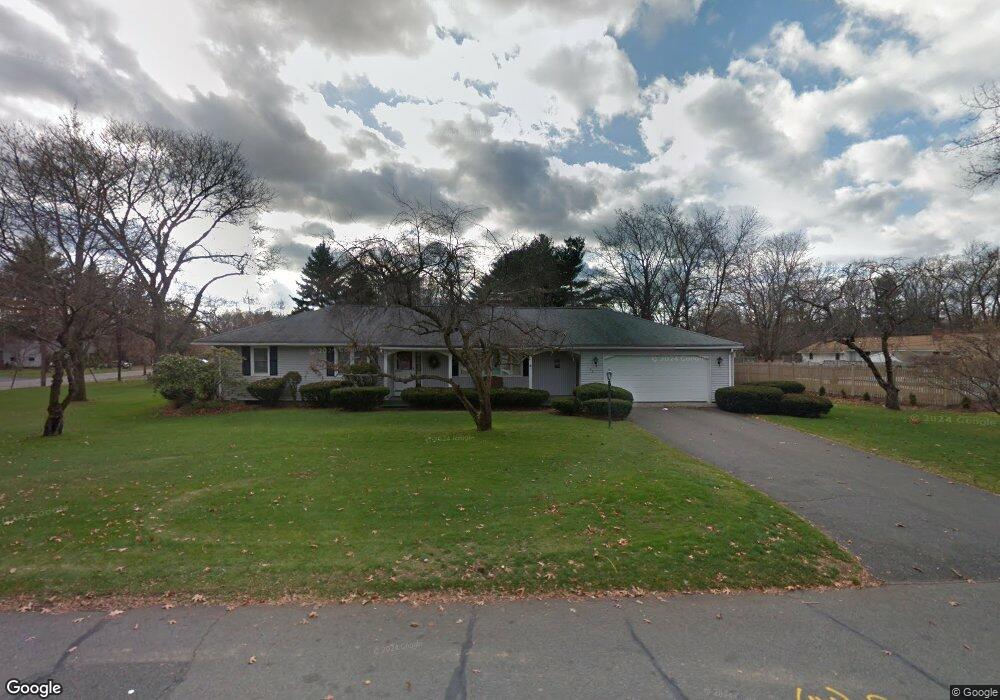
28 Viscount Rd Longmeadow, MA 01106
Estimated Value: $486,000 - $515,000
3
Beds
3
Baths
1,510
Sq Ft
$332/Sq Ft
Est. Value
About This Home
This home is located at 28 Viscount Rd, Longmeadow, MA 01106 and is currently estimated at $500,570, approximately $331 per square foot. 28 Viscount Rd is a home located in Hampden County with nearby schools including Blueberry Hill, Glenbrook Middle School, and Longmeadow High School.
Ownership History
Date
Name
Owned For
Owner Type
Purchase Details
Closed on
May 16, 2007
Sold by
Gressel Beverly and Gressel Yale
Bought by
Gressel Beverly and Stiller Jeanne Ann
Current Estimated Value
Purchase Details
Closed on
Oct 5, 1988
Sold by
Anderson Patricia
Bought by
Gressel Yale
Home Financials for this Owner
Home Financials are based on the most recent Mortgage that was taken out on this home.
Original Mortgage
$168,700
Interest Rate
10.64%
Mortgage Type
Purchase Money Mortgage
Create a Home Valuation Report for This Property
The Home Valuation Report is an in-depth analysis detailing your home's value as well as a comparison with similar homes in the area
Home Values in the Area
Average Home Value in this Area
Purchase History
| Date | Buyer | Sale Price | Title Company |
|---|---|---|---|
| Gressel Beverly | -- | -- | |
| Gressel Yale | $262,000 | -- |
Source: Public Records
Mortgage History
| Date | Status | Borrower | Loan Amount |
|---|---|---|---|
| Previous Owner | Gressel Yale | $98,589 | |
| Previous Owner | Gressel Yale | $153,600 | |
| Previous Owner | Gressel Yale | $168,700 |
Source: Public Records
Tax History Compared to Growth
Tax History
| Year | Tax Paid | Tax Assessment Tax Assessment Total Assessment is a certain percentage of the fair market value that is determined by local assessors to be the total taxable value of land and additions on the property. | Land | Improvement |
|---|---|---|---|---|
| 2025 | $9,403 | $445,200 | $174,100 | $271,100 |
| 2024 | $9,207 | $445,200 | $174,100 | $271,100 |
| 2023 | $8,957 | $390,800 | $158,800 | $232,000 |
| 2022 | $8,715 | $353,700 | $158,800 | $194,900 |
| 2021 | $8,370 | $338,300 | $151,200 | $187,100 |
| 2020 | $8,190 | $338,300 | $151,200 | $187,100 |
| 2019 | $7,822 | $324,700 | $151,200 | $173,500 |
| 2018 | $7,241 | $297,500 | $176,500 | $121,000 |
| 2017 | $7,015 | $297,500 | $176,500 | $121,000 |
| 2016 | $6,839 | $281,100 | $164,800 | $116,300 |
| 2015 | $6,602 | $279,500 | $163,200 | $116,300 |
Source: Public Records
Map
Nearby Homes
- 911 Williams St
- 111 Ashford Rd
- 361 Frank Smith Rd
- 64 Magnolia Cir
- 132 Coventry Ln
- 47 Academy Dr
- 124 Tecumseh Dr
- 217 Inverness Ln
- 120 Inverness Ln
- 202 Williamsburg Dr
- 196 Cambridge Cir
- 85 Inverness Ln
- 0 Dennis Rd
- 49 Wimbleton Dr
- 52 Smithfield Ct
- 67 Shady Side Dr
- 44 Wendover Rd
- 757 Shaker Rd
- 32 Edgewood Ave
- 136 Fenwood Rd
- 44 Vanguard Ln
- 10 Viscount Rd
- 34 Vanguard Ln
- 25 Viscount Rd
- 35 Viscount Rd
- 50 Viscount Rd
- 661 Williams St
- 45 Viscount Rd
- 39 Vanguard
- 715 Williams St
- 39 Vanguard Ln
- 39 Vanguard Ln Unit 39
- 29 Vanguard Ln
- 55 Viscount Rd
- 64 Viscount Rd
- 645 Williams St
- 725 Williams St
- 304 Captain Rd
- 292 Captain Rd
- 17 Merriweather Dr