J
Seller's Agent in 2025
Julie Conner
Real Estate Investment Opportunities, LLC
(928) 710-4911
29 Total Sales
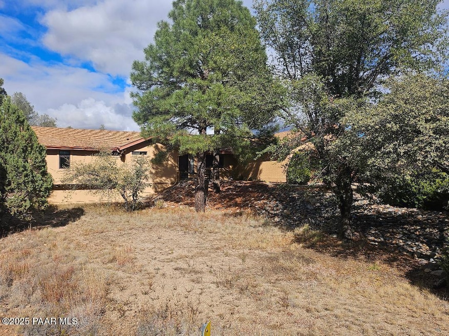


Discover this exceptional three-bedroom, two-bath home perfectly situated bordering the National Forest. The covered back porch opens directly to the natural beauty of the forest, while the front of the home captures Thumb Butte views. The lot feels especially spacious due to its location next to the subdivision drainage area, creating an added sense of openness.Inside, the home features a generous living room with a cozy gas fireplace, an open kitchen seamlessly connected to the dining area, and a desirable split floor plan. The primary suite is expansive and includes a large walk-in closet and en suite bathroom.Nestled in the sought-after Wildwood Subdivision, this home also benefits from low annual HOA dues of just $150
Last Agent to Sell the Property
Real Estate Investment Opportunities, LLC License #BR106071000 Listed on: 12/01/2025
| Date | Type | Sale Price | Title Company |
|---|---|---|---|
| Warranty Deed | $515,000 | Empire Title | |
| Cash Sale Deed | $175,000 | Yavapai Title Agency Inc | |
| Interfamily Deed Transfer | -- | None Available | |
| Quit Claim Deed | -- | -- | |
| Interfamily Deed Transfer | -- | -- | |
| Interfamily Deed Transfer | -- | -- | |
| Interfamily Deed Transfer | -- | -- | |
| Quit Claim Deed | -- | -- | |
| Quit Claim Deed | -- | -- |
| Date | Event | Price | List to Sale | Price per Sq Ft |
|---|---|---|---|---|
| 12/22/2025 12/22/25 | Sold | $515,000 | +4.0% | $262 / Sq Ft |
| 12/07/2025 12/07/25 | Pending | -- | -- | -- |
| 12/01/2025 12/01/25 | For Sale | $495,000 | -- | $252 / Sq Ft |
| Year | Tax Paid | Tax Assessment Tax Assessment Total Assessment is a certain percentage of the fair market value that is determined by local assessors to be the total taxable value of land and additions on the property. | Land | Improvement |
|---|---|---|---|---|
| 2026 | $2,404 | $53,791 | -- | -- |
| 2024 | $2,320 | $50,229 | -- | -- |
| 2023 | $2,320 | $40,462 | $11,062 | $29,400 |
| 2022 | $2,243 | $34,322 | $10,151 | $24,171 |
| 2021 | $2,307 | $34,429 | $10,094 | $24,335 |
| 2020 | $2,401 | $0 | $0 | $0 |
| 2019 | $2,355 | $0 | $0 | $0 |
| 2018 | $2,250 | $0 | $0 | $0 |
| 2017 | $2,140 | $0 | $0 | $0 |
| 2016 | $2,073 | $0 | $0 | $0 |
| 2015 | $1,687 | $0 | $0 | $0 |
| 2014 | -- | $0 | $0 | $0 |
J
Seller's Agent in 2025
Julie Conner
Real Estate Investment Opportunities, LLC
(928) 710-4911
29 Total Sales
L
Buyer's Agent in 2025
Lindsay Darnelle
eXp Realty
(928) 420-8370
15 Total Sales

Buyer Co-Listing Agent in 2025
Geoffrey Hyland, PLLC
eXp Realty
(928) 237-4425
1,656 Total Sales
Source: Prescott Area Association of REALTORS®
MLS Number: 1078077
APN: 115-02-076
Disclaimer: Certain information contained herein is derived from information provided by parties other than Homes.com. All information provided is deemed reliable, but is not guaranteed to be accurate and should be independently verified.
![]() IDX information is provided exclusively for personal, non-commercial use, and may not be used for any purpose other than to identify prospective properties consumers may be interested in purchasing. Information is deemed reliable but not guaranteed.
IDX information is provided exclusively for personal, non-commercial use, and may not be used for any purpose other than to identify prospective properties consumers may be interested in purchasing. Information is deemed reliable but not guaranteed.
Ask me questions while you tour the home.