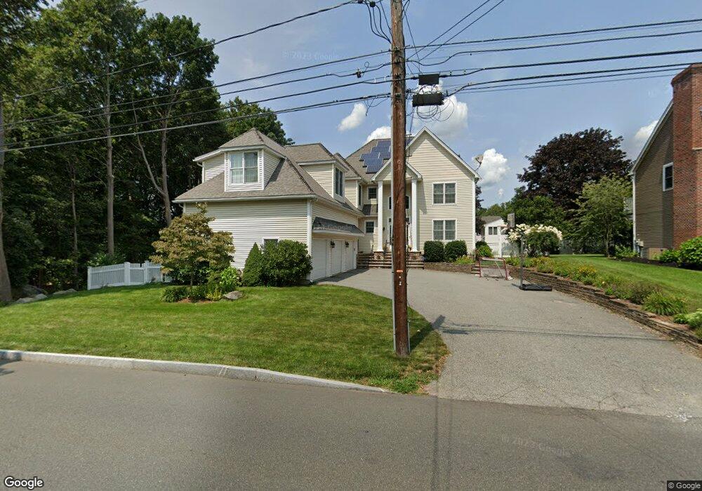
280 Broadway Stoneham, MA 02180
Bear Hill NeighborhoodEstimated Value: $1,333,884 - $1,468,000
4
Beds
3
Baths
3,540
Sq Ft
$395/Sq Ft
Est. Value
About This Home
This home is located at 280 Broadway, Stoneham, MA 02180 and is currently estimated at $1,398,721, approximately $395 per square foot. 280 Broadway is a home located in Middlesex County with nearby schools including Stoneham High School, St Joseph School, and St. Patrick Elementary School.
Ownership History
Date
Name
Owned For
Owner Type
Purchase Details
Closed on
Feb 16, 2024
Sold by
Ciriello Kenneth J and Ciriello Maria P
Bought by
Kenneth J Ciriello Ret and Ciriello
Current Estimated Value
Purchase Details
Closed on
Feb 5, 2004
Sold by
Catanzaro Irt and Catanzaro
Bought by
Ciriello Kenneth J and Ciriello Maria P
Purchase Details
Closed on
Oct 6, 2003
Sold by
Catanzaro Irt and Catanzaro
Bought by
Ciriello Maria P and Ciriello Kenneth J
Purchase Details
Closed on
Jun 30, 2000
Sold by
Roman Catholic Archb
Bought by
Catanzaro Richard R and Catanzaro Patricia M
Create a Home Valuation Report for This Property
The Home Valuation Report is an in-depth analysis detailing your home's value as well as a comparison with similar homes in the area
Home Values in the Area
Average Home Value in this Area
Purchase History
| Date | Buyer | Sale Price | Title Company |
|---|---|---|---|
| Kenneth J Ciriello Ret | -- | None Available | |
| Ciriello Kenneth J | -- | -- | |
| Ciriello Maria P | $297,500 | -- | |
| Catanzaro Richard R | $355,000 | -- |
Source: Public Records
Mortgage History
| Date | Status | Borrower | Loan Amount |
|---|---|---|---|
| Previous Owner | Catanzaro Richard R | $270,000 | |
| Previous Owner | Catanzaro Richard R | $275,000 | |
| Previous Owner | Catanzaro Richard R | $279,000 |
Source: Public Records
Tax History
| Year | Tax Paid | Tax Assessment Tax Assessment Total Assessment is a certain percentage of the fair market value that is determined by local assessors to be the total taxable value of land and additions on the property. | Land | Improvement |
|---|---|---|---|---|
| 2025 | $12,241 | $1,196,600 | $420,100 | $776,500 |
| 2024 | $11,838 | $1,117,800 | $400,100 | $717,700 |
| 2023 | $10,768 | $970,100 | $360,100 | $610,000 |
| 2022 | $9,506 | $913,200 | $340,100 | $573,100 |
| 2021 | $5,225 | $885,700 | $320,100 | $565,600 |
| 2020 | $9,339 | $865,500 | $310,100 | $555,400 |
| 2019 | $9,405 | $838,200 | $290,100 | $548,100 |
| 2018 | $8,647 | $789,300 | $270,100 | $519,200 |
| 2017 | $9,283 | $749,200 | $260,100 | $489,100 |
| 2016 | $9,253 | $728,600 | $265,100 | $463,500 |
| 2015 | $9,242 | $713,100 | $265,100 | $448,000 |
| 2014 | $9,162 | $679,200 | $235,100 | $444,100 |
Source: Public Records
Map
Nearby Homes
- 3 Valley Rd
- 62 High St Unit Lot 8
- 62 High St Unit 4
- 62 High St Unit Lot 5
- 62 High St Unit Lot 12
- 62 High St Unit 3
- 55 Bartley St
- 11 Valdora Dr
- 8 Steele St
- 58 Washington St
- 248 Albion St Unit 231
- 248 Albion St Unit 321
- 35 Tremont St
- 4 Garfield Ave
- 98 Main St Unit 2
- 21 Tremont St Unit B
- 21 Tremont St Unit A
- 66 Main St Unit 15A
- 95 Prospect St
- 12 Isola Ln
Your Personal Tour Guide
Ask me questions while you tour the home.