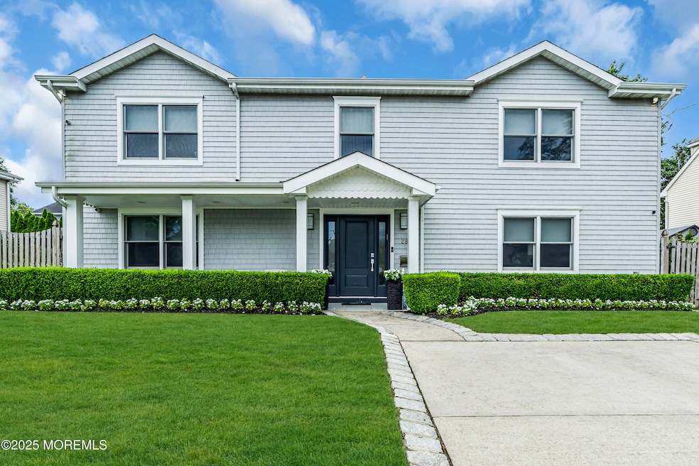
280 Cummings Ave Long Branch, NJ 07740
Estimated payment $12,609/month
Highlights
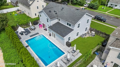
- Heated In Ground Pool
- New Kitchen
- Vaulted Ceiling
- Custom Home
- Wolf Appliances
- 4-minute walk to Van Court Park
About This Home
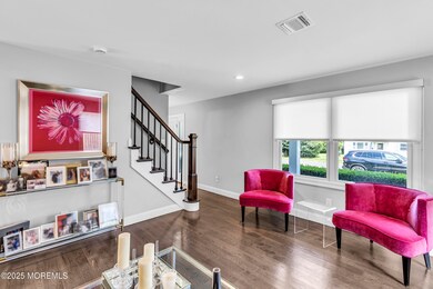
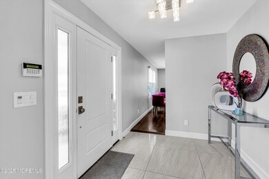
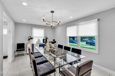
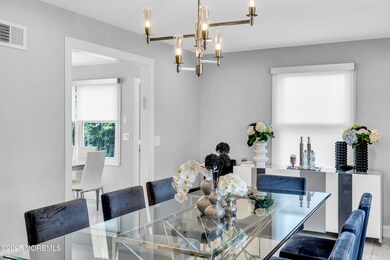
Here's the house you have been waiting for. Look no further than this Custom built 6 BD / 3 Bath 10 year young Colonial including a saltwater heated pool on a 75 x 100 lot. As you pass from the outside covered porch into the foyer which leads to the spacious Dining room on one side and the Living room on the other.Enjoy the open floor plan from the Family room to the eat in kitchen with breakfast bar. The kitchen includes top of the line stainless steel appliances from a Wolf stove, Bosch refrigerator to Ceasar stone quartz counter tops.All doors lead to the 18 x 36 saltwater pool surrounded by an expansive paver patio & private fenced yard.The primary en suite has vaulted ceilings, walk in closet & full bath,Vaulted ceilings also in the other 4 bedrooms upstairs.All closets have been fitted with custom shelving.One bedroom & bath on the main floor.Amongst the many upgrades this is a smart home including the security & camera systems,sound system,lighting,2 zone heating & cooling which all can be controlled from your phone. This one won't last!!
Home Details
Home Type
- Single Family
Est. Annual Taxes
- $18,547
Year Built
- Built in 1951
Lot Details
- 7,405 Sq Ft Lot
- Lot Dimensions are 75 x 100
- Fenced
- Level Lot
- Sprinkler System
Home Design
- Custom Home
- Colonial Architecture
- Contemporary Architecture
- Asphalt Rolled Roof
- Stucco Exterior
Interior Spaces
- 3,058 Sq Ft Home
- 2-Story Property
- Tray Ceiling
- Vaulted Ceiling
- Recessed Lighting
- Blinds
- French Doors
- Sliding Doors
- Pull Down Stairs to Attic
- Home Security System
Kitchen
- New Kitchen
- Eat-In Kitchen
- Breakfast Bar
- Dinette
- Gas Cooktop
- Stove
- Range Hood
- Bosch Dishwasher
- Dishwasher
- Wolf Appliances
- Granite Countertops
Flooring
- Wood
- Ceramic Tile
Bedrooms and Bathrooms
- 6 Bedrooms
- Main Floor Bedroom
- Walk-In Closet
- 3 Full Bathrooms
- Primary Bathroom includes a Walk-In Shower
Laundry
- Dryer
- Washer
Parking
- No Garage
- Parking Available
- Double-Wide Driveway
- Paved Parking
Eco-Friendly Details
- Energy-Efficient Appliances
- Energy-Efficient Thermostat
Pool
- Heated In Ground Pool
- Outdoor Pool
- Saltwater Pool
- Vinyl Pool
- Pool Equipment Stays
Outdoor Features
- Covered Patio or Porch
- Exterior Lighting
Schools
- Long Branch Middle School
Utilities
- Forced Air Zoned Heating and Cooling System
- Heating System Uses Natural Gas
- Programmable Thermostat
- Thermostat
- Natural Gas Water Heater
Community Details
- No Home Owners Association
Listing and Financial Details
- Assessor Parcel Number 27-00044-0000-00006
Map
Home Values in the Area
Average Home Value in this Area
Tax History
| Year | Tax Paid | Tax Assessment Tax Assessment Total Assessment is a certain percentage of the fair market value that is determined by local assessors to be the total taxable value of land and additions on the property. | Land | Improvement |
|---|---|---|---|---|
| 2025 | $18,547 | $1,375,500 | $832,500 | $543,000 |
| 2024 | $17,364 | $1,206,700 | $687,300 | $519,400 |
| 2023 | $17,364 | $1,118,100 | $622,300 | $495,800 |
| 2022 | $14,083 | $803,100 | $366,300 | $436,800 |
| 2021 | $14,083 | $703,800 | $295,300 | $408,500 |
| 2020 | $13,970 | $668,400 | $262,300 | $406,100 |
| 2019 | $12,980 | $617,500 | $230,300 | $387,200 |
| 2018 | $12,147 | $574,600 | $201,600 | $373,000 |
| 2017 | $11,245 | $545,600 | $179,600 | $366,000 |
| 2016 | $11,118 | $550,100 | $193,600 | $356,500 |
| 2015 | $11,070 | $263,900 | $140,600 | $123,300 |
| 2014 | $5,574 | $263,800 | $158,600 | $105,200 |
Property History
| Date | Event | Price | List to Sale | Price per Sq Ft |
|---|---|---|---|---|
| 09/10/2025 09/10/25 | Price Changed | $2,099,000 | -4.5% | $686 / Sq Ft |
| 07/20/2025 07/20/25 | For Sale | $2,199,000 | -- | $719 / Sq Ft |
Purchase History
| Date | Type | Sale Price | Title Company |
|---|---|---|---|
| Deed | -- | Fifth Avenue Title Agcy Inc | |
| Deed | $200,000 | None Available |
Mortgage History
| Date | Status | Loan Amount | Loan Type |
|---|---|---|---|
| Previous Owner | $350,000 | New Conventional | |
| Previous Owner | $120,000 | Purchase Money Mortgage |
Source: MOREMLS (Monmouth Ocean Regional REALTORS®)
MLS Number: 22521174
APN: 27-00044-0000-00006
Disclaimer: Certain information contained herein is derived from information provided by parties other than Homes.com. All information provided is deemed reliable, but is not guaranteed to be accurate and should be independently verified.
![]() IDX information is provided exclusively for personal, non-commercial use, and may not be used for any purpose other than to identify prospective properties consumers may be interested in purchasing.
IDX information is provided exclusively for personal, non-commercial use, and may not be used for any purpose other than to identify prospective properties consumers may be interested in purchasing.
Information is deemed reliable but not guaranteed.
- 251 Highland Ave
- 4 Clarence Ave
- 881 Red Oaks Dr
- 889 Red Oaks Dr
- 329 Yorke Ave
- 717 Norwood Ave
- 19 Clarence Ave
- 324 Cedar Ave
- 2 Jim Lynch Dr
- 3 Reid St
- 211 Cedar Ave
- 266 Lenox Ave
- 497 Marvin Dr
- 250 Alpern Ave
- 497 Norwood Ave
- 631 Hoey Ave
- 735 Greens Ave Unit 18A
- 8 Norwood Ct
- 807 Ocean Ave
- 65 Cedar Ave Unit C11
- 279 Cummings Ave
- 304 Cummings Ave
- 921 Woodgate Ave
- 278 Lake Ave
- 240 Norgrove Ave Unit ID1239742P
- 279 Lake Ave
- 191 Norgrove Ave
- 7 Elinore Ave
- 884 Red Oaks Dr
- 871 Red Oaks Dr
- 240 Castlewall Ave
- 975 van Court Ave
- 972 Woodgate Ave
- 301 Norgrove Place
- 866 Red Oaks Dr
- 872 Red Oaks Dr
- 980 Woodgate Ave
- 313 Yorke Ave
- 280 Oakley Ave
- 325 Oakley Ave
