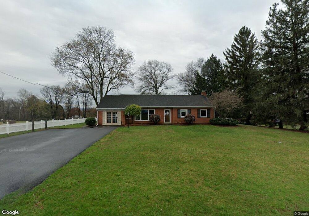
280 E Mount Airy Rd Stevens, PA 17578
Estimated Value: $252,000 - $276,426
--
Bed
--
Bath
--
Sq Ft
0.53
Acres
About This Home
This home is located at 280 E Mount Airy Rd, Stevens, PA 17578 and is currently estimated at $264,213. 280 E Mount Airy Rd is a home located in Lancaster County with nearby schools including Clay Elementary School, Ephrata Intermediate School, and Ephrata Senior High School.
Ownership History
Date
Name
Owned For
Owner Type
Purchase Details
Closed on
Oct 21, 2020
Sold by
Lapp John K and Lapp Rosemary E
Bought by
Lapp Amos Jay
Current Estimated Value
Home Financials for this Owner
Home Financials are based on the most recent Mortgage that was taken out on this home.
Original Mortgage
$260,000
Interest Rate
2.8%
Mortgage Type
Future Advance Clause Open End Mortgage
Purchase Details
Closed on
Feb 26, 2015
Sold by
Kline Myrleen
Bought by
Lapp John K
Home Financials for this Owner
Home Financials are based on the most recent Mortgage that was taken out on this home.
Original Mortgage
$245,000
Interest Rate
3.66%
Mortgage Type
Purchase Money Mortgage
Purchase Details
Closed on
Feb 3, 2010
Sold by
Kline Stanley and Kline Myrleen
Bought by
Kline Stanley and Kline Myrleen
Create a Home Valuation Report for This Property
The Home Valuation Report is an in-depth analysis detailing your home's value as well as a comparison with similar homes in the area
Home Values in the Area
Average Home Value in this Area
Purchase History
| Date | Buyer | Sale Price | Title Company |
|---|---|---|---|
| Lapp Amos Jay | -- | None Available | |
| Lapp John K | $245,000 | None Available | |
| Kline Stanley | -- | None Available |
Source: Public Records
Mortgage History
| Date | Status | Borrower | Loan Amount |
|---|---|---|---|
| Closed | Lapp Amos Jay | $260,000 | |
| Closed | Lapp John K | $245,000 |
Source: Public Records
Tax History Compared to Growth
Tax History
| Year | Tax Paid | Tax Assessment Tax Assessment Total Assessment is a certain percentage of the fair market value that is determined by local assessors to be the total taxable value of land and additions on the property. | Land | Improvement |
|---|---|---|---|---|
| 2025 | $1,702 | $74,300 | $47,700 | $26,600 |
| 2024 | $1,702 | $74,300 | $47,700 | $26,600 |
| 2023 | $1,658 | $74,300 | $47,700 | $26,600 |
| 2022 | $1,620 | $74,300 | $47,700 | $26,600 |
| 2021 | $1,585 | $74,300 | $47,700 | $26,600 |
| 2020 | $1,585 | $74,300 | $47,700 | $26,600 |
| 2019 | $1,563 | $74,300 | $47,700 | $26,600 |
| 2018 | $1,259 | $74,300 | $47,700 | $26,600 |
| 2017 | $1,616 | $63,400 | $31,300 | $32,100 |
| 2016 | $803 | $31,500 | $31,300 | $200 |
| 2015 | $159 | $31,500 | $31,300 | $200 |
| 2014 | $617 | $31,500 | $31,300 | $200 |
Source: Public Records
Map
Nearby Homes
- 125 Indiantown Rd
- 100 Lilly Dr
- 490 Weidmansville Rd
- 0 Weidmansville Rd
- 406 Mount Olive Ln
- 2002 W Main St Unit 74
- 2002 W Main St Unit 63
- 335 N Clay Rd
- Amberbrook Plan at Wyndale
- Northfield Plan at Wyndale
- Logan Plan at Wyndale
- Stonecroft Plan at Wyndale
- Darien Plan at Wyndale
- Atworth Plan at Wyndale
- Magnolia Plan at Wyndale
- Baker Plan at Wyndale
- Huntington Plan at Wyndale
- Westbrooke Plan at Wyndale
- Perry Plan at Wyndale
- Charlotte Plan at Wyndale
- 280 E Mount Airy Rd
- 260 E Mount Airy Rd
- 330 Indian Run Rd
- 250 E Mount Airy Rd
- 257 E Mount Airy Rd
- 240 E Mount Airy Rd
- 340 Indian Run Rd
- 255 E Mount Airy Rd
- 230 E Mount Airy Rd
- 335 E Mount Airy Rd
- 320 E Mount Airy Rd
- 220 E Mount Airy Rd
- 220 E Mount Airy Rd
- 375 Indian Run Rd
- 355 E Mount Airy Rd
- 330 E Mount Airy Rd
- 345 E Mount Airy Rd
- 350 E Mount Airy Rd
- 200 E Mount Airy Rd
- 365 E Mount Airy Rd