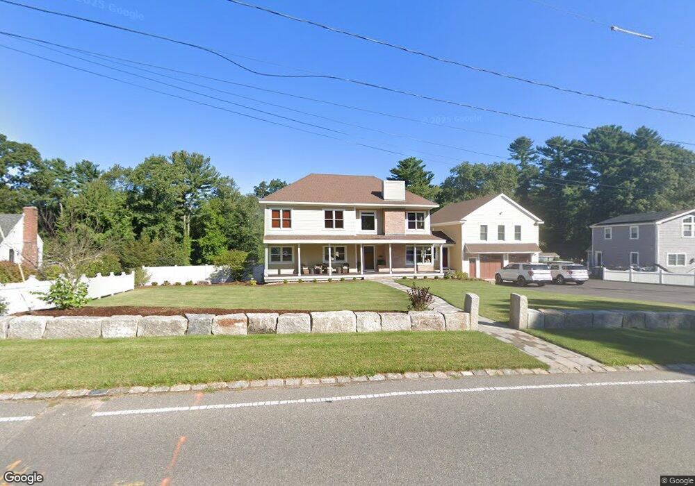
280 East St Hanover, MA 02339
Estimated Value: $711,000 - $1,374,000
3
Beds
2
Baths
1,194
Sq Ft
$845/Sq Ft
Est. Value
About This Home
This home is located at 280 East St, Hanover, MA 02339 and is currently estimated at $1,009,337, approximately $845 per square foot. 280 East St is a home located in Plymouth County with nearby schools including Hanover High School, Cadence Academy Preschool - Hanover, and The Master's Academy.
Ownership History
Date
Name
Owned For
Owner Type
Purchase Details
Closed on
Oct 28, 2016
Sold by
Delmonico Ray and Delmonico Amanda
Bought by
Delmonico Raymond J and Delmonico Manada
Current Estimated Value
Purchase Details
Closed on
Jul 1, 2009
Sold by
Crimi Barbara J
Bought by
Delmonico Raymond and Delmonico Joanne
Home Financials for this Owner
Home Financials are based on the most recent Mortgage that was taken out on this home.
Original Mortgage
$311,258
Interest Rate
4.86%
Mortgage Type
Purchase Money Mortgage
Purchase Details
Closed on
Jun 21, 2004
Sold by
Crimi Vincent J and Crimi Barbara J
Bought by
Crimi Barbara J
Create a Home Valuation Report for This Property
The Home Valuation Report is an in-depth analysis detailing your home's value as well as a comparison with similar homes in the area
Home Values in the Area
Average Home Value in this Area
Purchase History
| Date | Buyer | Sale Price | Title Company |
|---|---|---|---|
| Delmonico Raymond J | -- | -- | |
| Delmonico Raymond | $317,000 | -- | |
| Crimi Barbara J | -- | -- |
Source: Public Records
Mortgage History
| Date | Status | Borrower | Loan Amount |
|---|---|---|---|
| Previous Owner | Crimi Barbara J | $311,258 | |
| Previous Owner | Crimi Barbara J | $50,000 | |
| Previous Owner | Crimi Barbara J | $80,000 |
Source: Public Records
Tax History Compared to Growth
Tax History
| Year | Tax Paid | Tax Assessment Tax Assessment Total Assessment is a certain percentage of the fair market value that is determined by local assessors to be the total taxable value of land and additions on the property. | Land | Improvement |
|---|---|---|---|---|
| 2025 | $10,037 | $812,700 | $291,300 | $521,400 |
| 2024 | $9,798 | $763,100 | $291,300 | $471,800 |
| 2023 | $9,668 | $716,700 | $266,000 | $450,700 |
| 2022 | $10,317 | $676,500 | $253,300 | $423,200 |
| 2021 | $4,936 | $647,100 | $208,200 | $438,900 |
| 2020 | $6,855 | $420,300 | $219,800 | $200,500 |
| 2019 | $0 | $397,500 | $219,800 | $177,700 |
| 2018 | $7,734 | $363,300 | $219,800 | $143,500 |
| 2017 | $7,835 | $346,000 | $215,400 | $130,600 |
| 2016 | $5,520 | $327,400 | $196,800 | $130,600 |
| 2015 | $4,785 | $296,300 | $183,100 | $113,200 |
Source: Public Records
Map
Nearby Homes
- 14 Longwood Ln Unit 14
- 198 Pine St
- 37 Tara Dr
- 20 Meadow Brook Rd
- 28 Riverside Dr
- 11 Silver Brook Ln Unit 11
- 10 Shrine Rd
- 16 Broad Oak Way
- 28 Old Shipyard Ln
- 61 Deborah Rd
- 260 River St
- 250 River St
- 0 Island View Cir
- 62 Larchmont Ln
- 2 Curtis Farm Rd
- 133 Brigantine Cir
- 239 Candlewood Ln
- 180 Elm St
- 55 Shipyard Ln
- 72 Chittenden Ln