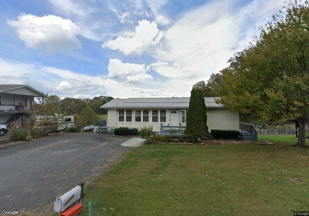
280 Jones St Blairsville, GA 30512
Estimated Value: $272,000 - $290,000
3
Beds
1
Bath
1,456
Sq Ft
$193/Sq Ft
Est. Value
About This Home
This home is located at 280 Jones St, Blairsville, GA 30512 and is currently estimated at $280,320, approximately $192 per square foot. 280 Jones St is a home located in Union County with nearby schools including Union County Primary School, Union County Elementary School, and Union County Middle School.
Ownership History
Date
Name
Owned For
Owner Type
Purchase Details
Closed on
Apr 4, 2007
Sold by
Potts Ray E
Bought by
Chen Songqiu
Current Estimated Value
Home Financials for this Owner
Home Financials are based on the most recent Mortgage that was taken out on this home.
Original Mortgage
$80,000
Outstanding Balance
$48,237
Interest Rate
6.1%
Mortgage Type
New Conventional
Estimated Equity
$232,083
Purchase Details
Closed on
Feb 28, 1980
Bought by
Potts Ray E and Potts Sue C
Create a Home Valuation Report for This Property
The Home Valuation Report is an in-depth analysis detailing your home's value as well as a comparison with similar homes in the area
Home Values in the Area
Average Home Value in this Area
Purchase History
| Date | Buyer | Sale Price | Title Company |
|---|---|---|---|
| Chen Songqiu | $125,000 | -- | |
| Potts Ray E | -- | -- |
Source: Public Records
Mortgage History
| Date | Status | Borrower | Loan Amount |
|---|---|---|---|
| Open | Chen Songqiu | $80,000 |
Source: Public Records
Tax History Compared to Growth
Tax History
| Year | Tax Paid | Tax Assessment Tax Assessment Total Assessment is a certain percentage of the fair market value that is determined by local assessors to be the total taxable value of land and additions on the property. | Land | Improvement |
|---|---|---|---|---|
| 2024 | $1,446 | $111,424 | $4,680 | $106,744 |
| 2023 | $1,562 | $107,104 | $4,680 | $102,424 |
| 2022 | $702 | $52,744 | $4,680 | $48,064 |
| 2021 | $693 | $43,984 | $4,680 | $39,304 |
| 2020 | $531 | $28,093 | $5,392 | $22,701 |
| 2019 | $502 | $28,093 | $5,392 | $22,701 |
| 2018 | $548 | $28,093 | $5,392 | $22,701 |
| 2017 | $493 | $28,093 | $5,392 | $22,701 |
| 2016 | $494 | $28,093 | $5,392 | $22,701 |
| 2015 | $498 | $28,093 | $5,392 | $22,701 |
| 2013 | -- | $28,093 | $5,392 | $22,701 |
Source: Public Records
Map
Nearby Homes
- 130 Emory Cir
- 490 Jones St
- 117 Serene Way
- 9 Pruitt Cir
- 192 Brookwood Dr
- 78 Reed White Dr
- Lot 89 Thirteen Hundred
- 114 Kimsey St Unit 36-39
- 114 Kimsey St
- 9.36 AC Highway 515 W
- Lt 23 Scouts Ridge Rd
- 457 Young Blood Dr
- 288 Kimsey St
- 0 Blue Ridge Hwy Unit 418722
- 0 Blue Ridge Hwy Unit 7596216
- 0 Blue Ridge Hwy Unit A-2, C-1 10541532
- 27 Williams Cir
- 134 Birdie Ln
- 134 Birdie Ln Unit TRACT-1
- 103 Birdie Ln