S
Seller's Agent in 2025
Stacy Wall Shirley
Keller Williams Realty Atlanta Partners
(404) 379-4147
1 in this area
7 Total Sales
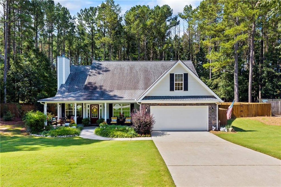
Charming and spacious 4-Bedroom and 3-Bath Bungalow in Social Circle!
Welcome to this move in ready home, completely updated and perfect for modern living. This traditional bungalow boasts a cozy, warm atmosphere while offering all the conveniences of an contemporary home. Featuring new hard surface water proof floors on the main level, and new kitchen appliances, this home is durable and easy to maintain. It is ready for you to move in and make it your own with little effort.
The spacious 4 bedrooms and 3 full bathrooms provide ample space for a family, guests, or a home office. Enjoy the serenity of a large yard that backs up to a peaceful creek and woods, offering both privacy fence and natural beauty.
Located in Social Circle, GA, this home is situated in a highly sought-after Walton County School District, making it an ideal choice for families. Whether you're relaxing indoors or enjoying the fire-pit out doors in the fall, this home provides the perfect balance of comfort and style.
Come see if for yourself-this one won't last long!
Last Agent to Sell the Property
Keller Williams Realty Atlanta Partners License #414180 Listed on: 08/28/2025

| Date | Type | Sale Price | Title Company |
|---|---|---|---|
| Warranty Deed | $375,000 | -- | |
| Warranty Deed | $169,500 | -- | |
| Deed | $172,000 | -- | |
| Foreclosure Deed | $169,424 | -- |
| Date | Status | Loan Amount | Loan Type |
|---|---|---|---|
| Previous Owner | $161,025 | New Conventional | |
| Previous Owner | $137,600 | New Conventional |
| Date | Event | Price | List to Sale | Price per Sq Ft |
|---|---|---|---|---|
| 09/30/2025 09/30/25 | Sold | $375,000 | -2.3% | $182 / Sq Ft |
| 09/16/2025 09/16/25 | Pending | -- | -- | -- |
| 08/28/2025 08/28/25 | For Sale | $384,000 | -- | $186 / Sq Ft |
| Year | Tax Paid | Tax Assessment Tax Assessment Total Assessment is a certain percentage of the fair market value that is determined by local assessors to be the total taxable value of land and additions on the property. | Land | Improvement |
|---|---|---|---|---|
| 2024 | $4,721 | $132,720 | $24,000 | $108,720 |
| 2023 | $4,461 | $123,360 | $22,000 | $101,360 |
| 2022 | $1,054 | $101,240 | $17,000 | $84,240 |
| 2021 | $923 | $88,600 | $15,200 | $73,400 |
| 2020 | $869 | $81,400 | $14,000 | $67,400 |
| 2019 | $839 | $72,680 | $12,000 | $60,680 |
| 2018 | $793 | $72,680 | $12,000 | $60,680 |
| 2017 | $2,947 | $70,520 | $12,000 | $58,520 |
| 2016 | $677 | $65,240 | $12,000 | $53,240 |
| 2015 | $565 | $54,280 | $8,000 | $46,280 |
| 2014 | $542 | $49,640 | $8,000 | $41,640 |
S
Seller's Agent in 2025
Stacy Wall Shirley
Keller Williams Realty Atlanta Partners
(404) 379-4147
1 in this area
7 Total Sales
Buyer's Agent in 2025
Patricia Bright
RE/MAX
(404) 444-0383
1 in this area
43 Total Sales
Source: First Multiple Listing Service (FMLS)
MLS Number: 7622438
APN: NS08C00000069000
![]() Listings identified with the FMLS IDX logo come from FMLS and are held by brokerage firms other than the owner of this website. The listing brokerage is identified in any listing details. Information is deemed reliable but is not guaranteed. If you believe any FMLS listing contains material that infringes your copyrighted work please visit www.fmls.com/dmca to review our DMCA policy and learn how to submit a takedown request. © 2025 First Multiple Listing Service, Inc.
Listings identified with the FMLS IDX logo come from FMLS and are held by brokerage firms other than the owner of this website. The listing brokerage is identified in any listing details. Information is deemed reliable but is not guaranteed. If you believe any FMLS listing contains material that infringes your copyrighted work please visit www.fmls.com/dmca to review our DMCA policy and learn how to submit a takedown request. © 2025 First Multiple Listing Service, Inc.
Disclaimer: Certain information contained herein is derived from information provided by parties other than Homes.com. All information provided is deemed reliable, but is not guaranteed to be accurate and should be independently verified.