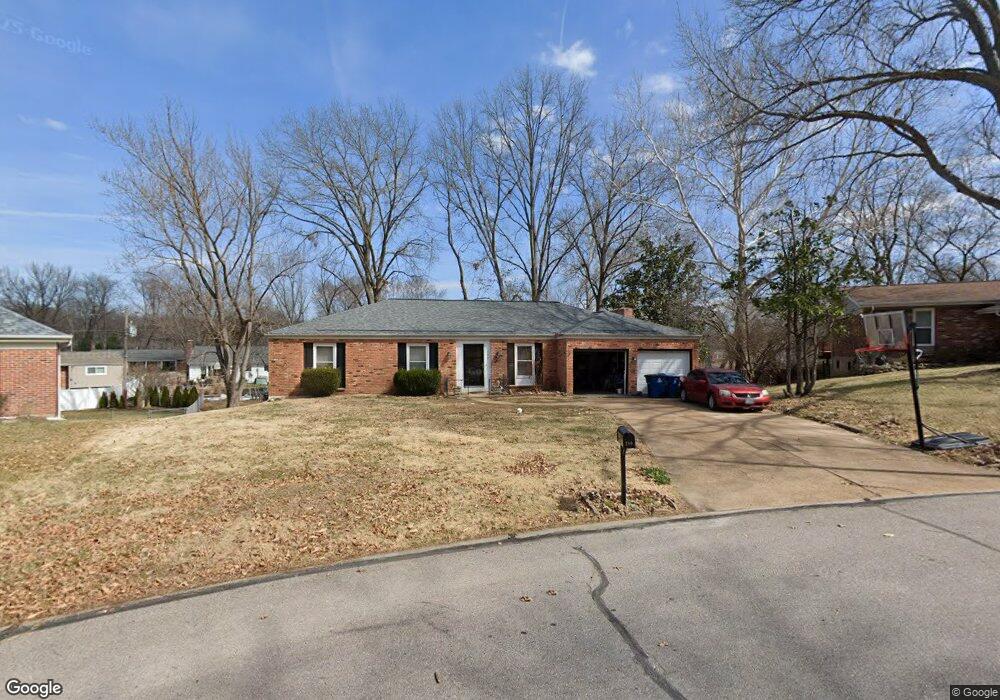
280 Portwind Place Ballwin, MO 63021
Estimated Value: $357,327 - $401,000
3
Beds
3
Baths
1,728
Sq Ft
$219/Sq Ft
Est. Value
About This Home
This home is located at 280 Portwind Place, Ballwin, MO 63021 and is currently estimated at $378,082, approximately $218 per square foot. 280 Portwind Place is a home located in St. Louis County with nearby schools including Ballwin Elementary School, Selvidge Middle School, and Marquette Sr. High School.
Ownership History
Date
Name
Owned For
Owner Type
Purchase Details
Closed on
Aug 16, 2019
Sold by
Walton Richard L and Hettick Donna J
Bought by
Walton Sara
Current Estimated Value
Home Financials for this Owner
Home Financials are based on the most recent Mortgage that was taken out on this home.
Original Mortgage
$159,493
Outstanding Balance
$140,223
Interest Rate
4.5%
Mortgage Type
FHA
Estimated Equity
$237,859
Create a Home Valuation Report for This Property
The Home Valuation Report is an in-depth analysis detailing your home's value as well as a comparison with similar homes in the area
Home Values in the Area
Average Home Value in this Area
Purchase History
| Date | Buyer | Sale Price | Title Company |
|---|---|---|---|
| Walton Sara | $225,000 | Title Partners Agency Llc |
Source: Public Records
Mortgage History
| Date | Status | Borrower | Loan Amount |
|---|---|---|---|
| Open | Walton Sara | $159,493 |
Source: Public Records
Tax History
| Year | Tax Paid | Tax Assessment Tax Assessment Total Assessment is a certain percentage of the fair market value that is determined by local assessors to be the total taxable value of land and additions on the property. | Land | Improvement |
|---|---|---|---|---|
| 2025 | $3,745 | $61,710 | $21,890 | $39,820 |
| 2024 | $3,745 | $53,450 | $18,240 | $35,210 |
| 2023 | $3,745 | $53,450 | $18,240 | $35,210 |
| 2022 | $3,925 | $52,100 | $18,240 | $33,860 |
| 2021 | $3,897 | $52,100 | $18,240 | $33,860 |
| 2020 | $3,619 | $46,110 | $17,230 | $28,880 |
| 2019 | $3,633 | $46,110 | $17,230 | $28,880 |
| 2018 | $3,557 | $42,560 | $13,430 | $29,130 |
| 2017 | $3,473 | $42,560 | $13,430 | $29,130 |
| 2016 | $3,097 | $36,470 | $9,600 | $26,870 |
| 2015 | $3,035 | $36,470 | $9,600 | $26,870 |
| 2014 | $2,971 | $34,810 | $10,850 | $23,960 |
Source: Public Records
Map
Nearby Homes
- 429 Fairview Ct
- 410 Woodland Hill Ct
- 3 Chappel Ct
- 756 Alexander Mark Way
- 275 Essen Ct Unit TBB
- 313 Saint Lawrence Dr
- 212 Lakeside Dr
- 408 Saint Lawrence Dr
- 365 Palermo Dr
- 510 Wicklow Dr
- 237 Ballwin Ave
- 798 Canary Dr
- 729 Tuscan Valley Ct
- 899 Oklahoma Ave
- 401 Hillcrest Blvd
- 312 Ballwin Ave
- 947 Bellestri Dr
- 313 Brightfield Dr
- 752 Rockridge Dr
- 846 Pheasant Woods Dr
- 278 Portwind Place
- 282 Portwind Place
- 268 Treasure Cove
- 270 Treasure Cove
- 272 Treasure Cove
- 281 Portwind Place
- 284 Portwind Place
- 276 Treasure Cove
- 279 Amber Jack Dr
- 274 Treasure Cove
- 260 Treasure Cove
- 281 Amber Jack Dr
- 230 Towercliffe Dr
- 283 Amber Jack Dr
- 286 Portwind Place
- 283 Portwind Place
- 261 Treasure Cove
- 259 Treasure Cove
- 285 Amber Jack Dr
- 257 Treasure Cove
Your Personal Tour Guide
Ask me questions while you tour the home.