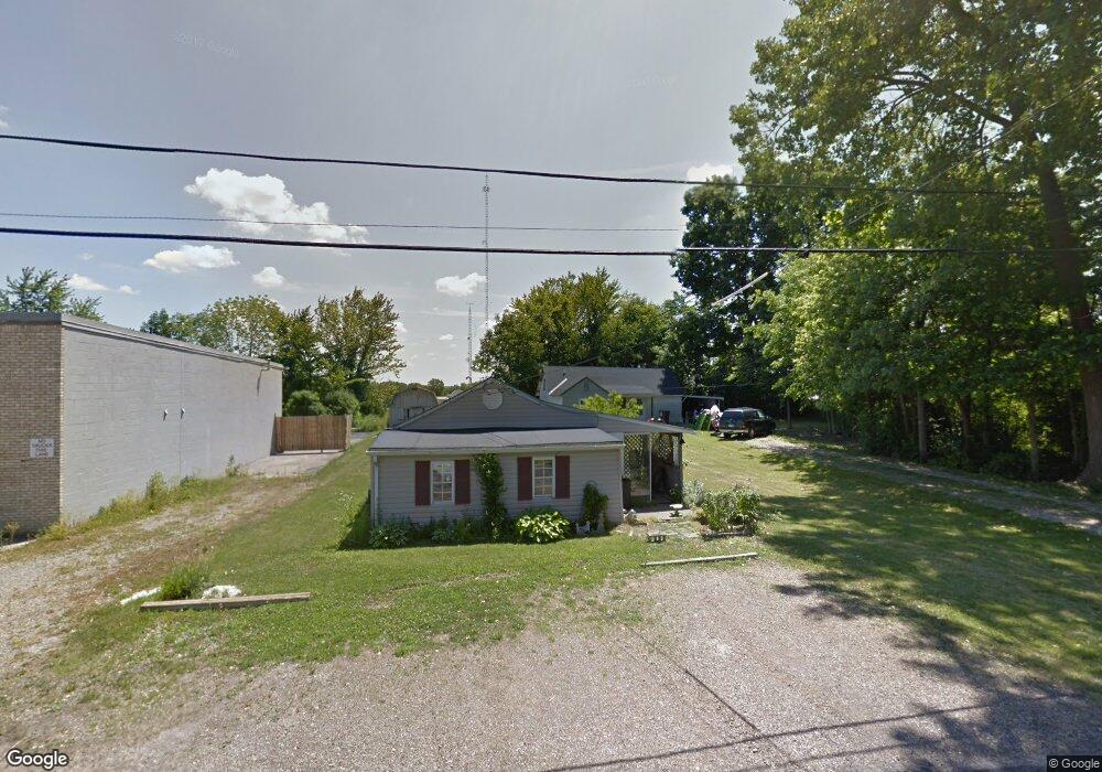
280 Tower Dr Mansfield, OH 44906
Estimated Value: $80,000 - $184,000
Studio
1
Bath
--
Sq Ft
5,140
Sq Ft Lot
About This Home
This home is located at 280 Tower Dr, Mansfield, OH 44906 and is currently estimated at $127,759. 280 Tower Dr is a home located in Richland County with nearby schools including Goal Digital Academy, Mansfield Elective Academy, and Foundation Academy.
Ownership History
Date
Name
Owned For
Owner Type
Purchase Details
Closed on
May 10, 2016
Sold by
Richland County Land Reutilization Corpo
Bought by
Dumas Joseph Paul
Current Estimated Value
Purchase Details
Closed on
Nov 10, 2014
Sold by
State Of Ohio
Bought by
Richland County Land Reutilization Corpo
Purchase Details
Closed on
Apr 9, 1998
Sold by
Gross Donald J
Bought by
Heaton Wanda
Purchase Details
Closed on
Mar 19, 1998
Sold by
Imhoff Jacqueline L
Bought by
Gross Donald J and Gross Desiree L
Purchase Details
Closed on
Aug 24, 1993
Sold by
Todd Auguesta
Bought by
Todd Jacqueline L
Create a Home Valuation Report for This Property
The Home Valuation Report is an in-depth analysis detailing your home's value as well as a comparison with similar homes in the area
Home Values in the Area
Average Home Value in this Area
Purchase History
| Date | Buyer | Sale Price | Title Company |
|---|---|---|---|
| Dumas Joseph Paul | -- | None Available | |
| Richland County Land Reutilization Corpo | -- | None Available | |
| Heaton Wanda | $40,850 | -- | |
| Gross Donald J | $29,900 | -- | |
| Todd Jacqueline L | -- | -- |
Source: Public Records
Tax History
| Year | Tax Paid | Tax Assessment Tax Assessment Total Assessment is a certain percentage of the fair market value that is determined by local assessors to be the total taxable value of land and additions on the property. | Land | Improvement |
|---|---|---|---|---|
| 2024 | $67 | $1,680 | $1,680 | $0 |
| 2023 | $80 | $1,680 | $1,680 | $0 |
| 2022 | $103 | $1,800 | $1,800 | $0 |
| 2021 | $104 | $1,800 | $1,800 | $0 |
| 2020 | $106 | $1,800 | $1,800 | $0 |
| 2019 | $117 | $1,800 | $1,800 | $0 |
| 2018 | $116 | $1,800 | $1,800 | $0 |
| 2017 | $113 | $1,800 | $1,800 | $0 |
| 2016 | $110 | $1,710 | $1,710 | $0 |
| 2015 | $385 | $6,390 | $1,710 | $4,680 |
| 2014 | $305 | $6,390 | $1,710 | $4,680 |
| 2012 | $305 | $6,720 | $1,800 | $4,920 |
Source: Public Records
Map
Nearby Homes
- 0 W Fourth St - Trimble Lenox
- 340 Boston Ave
- 799 Mcpherson St
- 339 Buckeye Ave
- 0 Lemley Ave Unit 9070540
- 143 Buckeye Ave
- 688 Mcpherson St
- 0 State Route 314 Unit 9069650
- 230 Rae Ave
- 641 Averill Ave
- 988 Kentland Dr
- 31 Parkwood Blvd
- 519 Heineman Blvd
- 173 Brookwood Way N
- 572 France St
- 129 Fairlawn Ave
- 135 Fairlawn Ave
- 728 N Trimble Rd
- 143 Fairlawn Ave
- 447 Spayer Ln
Your Personal Tour Guide
Ask me questions while you tour the home.