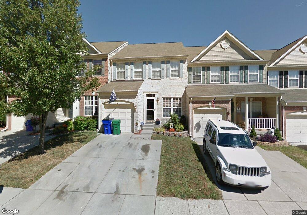
280 Trudy Ct Forest Hill, MD 21050
Estimated Value: $391,000 - $463,000
Studio
3
Baths
1,992
Sq Ft
$209/Sq Ft
Est. Value
About This Home
This home is located at 280 Trudy Ct, Forest Hill, MD 21050 and is currently estimated at $415,441, approximately $208 per square foot. 280 Trudy Ct is a home located in Harford County with nearby schools including Forest Hill Elementary School, Bel Air Middle School, and Bel Air High School.
Ownership History
Date
Name
Owned For
Owner Type
Purchase Details
Closed on
Jan 2, 2008
Sold by
Scribner David
Bought by
Huber John J and Huber Stacy N
Current Estimated Value
Home Financials for this Owner
Home Financials are based on the most recent Mortgage that was taken out on this home.
Original Mortgage
$315,600
Outstanding Balance
$196,722
Interest Rate
6.27%
Mortgage Type
VA
Estimated Equity
$218,719
Purchase Details
Closed on
Dec 20, 2007
Sold by
Scribner David
Bought by
Huber John J and Huber Stacy N
Home Financials for this Owner
Home Financials are based on the most recent Mortgage that was taken out on this home.
Original Mortgage
$315,600
Outstanding Balance
$196,722
Interest Rate
6.27%
Mortgage Type
VA
Estimated Equity
$218,719
Purchase Details
Closed on
Aug 1, 2003
Sold by
Coady Michael John
Bought by
Scribner David and Lineberry Kimberly
Purchase Details
Closed on
May 6, 2002
Sold by
Spenceola/Bellevue Llc
Bought by
Coady Michael John
Create a Home Valuation Report for This Property
The Home Valuation Report is an in-depth analysis detailing your home's value as well as a comparison with similar homes in the area
Home Values in the Area
Average Home Value in this Area
Purchase History
| Date | Buyer | Sale Price | Title Company |
|---|---|---|---|
| Huber John J | $309,000 | -- | |
| Huber John J | $309,000 | -- | |
| Scribner David | $223,000 | -- | |
| Coady Michael John | $185,440 | -- |
Source: Public Records
Mortgage History
| Date | Status | Borrower | Loan Amount |
|---|---|---|---|
| Open | Huber John J | $315,600 | |
| Closed | Huber John J | $315,600 | |
| Closed | Coady Michael John | -- |
Source: Public Records
Tax History
| Year | Tax Paid | Tax Assessment Tax Assessment Total Assessment is a certain percentage of the fair market value that is determined by local assessors to be the total taxable value of land and additions on the property. | Land | Improvement |
|---|---|---|---|---|
| 2025 | $3,451 | $330,800 | $72,000 | $258,800 |
| 2024 | $3,451 | $316,600 | $0 | $0 |
| 2023 | $3,296 | $302,400 | $0 | $0 |
| 2022 | $3,141 | $288,200 | $72,000 | $216,200 |
| 2021 | $3,242 | $284,567 | $0 | $0 |
| 2020 | $3,242 | $280,933 | $0 | $0 |
| 2019 | $3,200 | $277,300 | $65,000 | $212,300 |
| 2018 | $3,148 | $275,300 | $0 | $0 |
| 2017 | $3,125 | $277,300 | $0 | $0 |
| 2016 | $140 | $271,300 | $0 | $0 |
| 2015 | $3,105 | $267,300 | $0 | $0 |
| 2014 | $3,105 | $263,300 | $0 | $0 |
Source: Public Records
Map
Nearby Homes
- 305 Esther Dr
- 2027 Mardic Dr
- 2033 Mardic Dr
- 313 Willrich Cir Unit E
- 311 Willrich Cir Unit G
- 2135 Mardic Dr
- 310 Willrich Cir
- 16 Wagner Way
- 2013 Columbine Ln
- 137 Spencer Cir
- 407 Shellbark Ct
- 332 Ponfield Rd E
- 1721 Chrisemmett Ct Unit 3A
- 318 Streett Cir
- 138 Paden Ct
- 314 Streett Cir
- 205 Kimary Ct Unit H
- 206 Kimary Ct Unit 1B
- 107 J Sunshine Ct
- 202 Kimary Ct Unit 1A
Your Personal Tour Guide
Ask me questions while you tour the home.