Estimated Value: $214,000
3
Beds
2
Baths
1,385
Sq Ft
$155/Sq Ft
Est. Value
About This Home
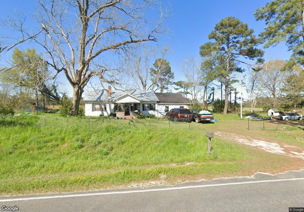
This home is located at 2807 Lonnie Grimsley Rd, Adel, GA 31620 and is currently estimated at $214,000, approximately $154 per square foot. 2807 Lonnie Grimsley Rd is a home located in Cook County with nearby schools including Cook Primary School, Cook Elementary School, and Cook County Middle School.
Ownership History
Date
Name
Owned For
Owner Type
Purchase Details
Closed on
Apr 18, 2018
Sold by
Grimsley Donald A
Bought by
Joiner Ernest G and Joiner Annette
Current Estimated Value
Purchase Details
Closed on
Jun 26, 2017
Sold by
Grimsley Donald A
Bought by
Swilley Reginald J
Home Financials for this Owner
Home Financials are based on the most recent Mortgage that was taken out on this home.
Original Mortgage
$59,170
Interest Rate
3.95%
Mortgage Type
New Conventional
Purchase Details
Closed on
Oct 30, 2014
Sold by
Grimsley Julian R
Bought by
Grimsley Donald A
Purchase Details
Closed on
Aug 19, 2010
Sold by
Grimsley Myrtice J
Bought by
Grimsley Donald
Create a Home Valuation Report for This Property
The Home Valuation Report is an in-depth analysis detailing your home's value as well as a comparison with similar homes in the area
Home Values in the Area
Average Home Value in this Area
Purchase History
| Date | Buyer | Sale Price | Title Company |
|---|---|---|---|
| Joiner Ernest G | $120,325 | -- | |
| Gmp Properties Llc | $25,100 | -- | |
| Swilley Reginald J | $61,000 | -- | |
| Grimsley Donald A | -- | -- | |
| Grimsley Donald | -- | -- | |
| Grimsley Julian | -- | -- |
Source: Public Records
Mortgage History
| Date | Status | Borrower | Loan Amount |
|---|---|---|---|
| Previous Owner | Swilley Reginald J | $59,170 |
Source: Public Records
Tax History Compared to Growth
Tax History
| Year | Tax Paid | Tax Assessment Tax Assessment Total Assessment is a certain percentage of the fair market value that is determined by local assessors to be the total taxable value of land and additions on the property. | Land | Improvement |
|---|---|---|---|---|
| 2024 | $597 | $60,374 | $60,374 | $0 |
| 2023 | $580 | $60,374 | $60,374 | $0 |
| 2022 | $563 | $53,906 | $53,906 | $0 |
| 2021 | $587 | $53,906 | $53,906 | $0 |
| 2020 | $570 | $53,906 | $53,906 | $0 |
| 2019 | $554 | $53,906 | $53,906 | $0 |
| 2018 | $2,089 | $72,236 | $72,236 | $0 |
| 2017 | $1,101 | $88,160 | $74,476 | $13,684 |
| 2016 | $1,042 | $86,760 | $74,476 | $12,284 |
| 2015 | $1,005 | $86,760 | $74,476 | $12,284 |
| 2014 | $1,007 | $86,760 | $74,476 | $12,284 |
| 2013 | -- | $86,760 | $74,476 | $12,284 |
Source: Public Records
Map
Nearby Homes
- 3037 Lonnie Grimsley Rd
- 0 Lumby Smith Rd
- 131 Lakeview Ct
- 13.89 ac Lumby Smith & Hwy 37
- 1918 Register Rd
- 0 Mclendon Rd
- 1296 Boone Rd
- 11010 Barneyville Rd
- 137 Hood Dr
- 02 Lakeridge Dr
- 01 Lakeridge Dr
- 8422 Massee Post Rd
- 173 Indian Creek Cir
- 1510 Cecil Rd
- 1377 Hutchinson Parrish Rd
- 1507 S Dogwood Dr
- 93 Oak Forrest Dr
- 1309 S Dogwood Dr
- 1102 S Dogwood Dr
- 1410 Forest Way
- 2961 Lonnie Grimsley Rd
- 14845 Highway 76
- 14800 Highway 76
- 2244 Lonnie Grimsley Rd
- 14724 Highway 76
- 2823 Register Rd
- 2823 Register Rd
- 2785 Register Rd
- 246 Highway 76 W
- 4090 Boone Rd
- 357 Cornelius Rd
- 622 Cornelius Rd
- 5225 Boone Rd
- 754 Cornelius Rd
- 66 McCorvey Rd
- 830 Cornelius Rd
- 4799 Hutchinson Parrish Rd
- 4799 Hutchinson Parrish Rd
- 337 Highway 76 W
- 879 Cornelius Rd