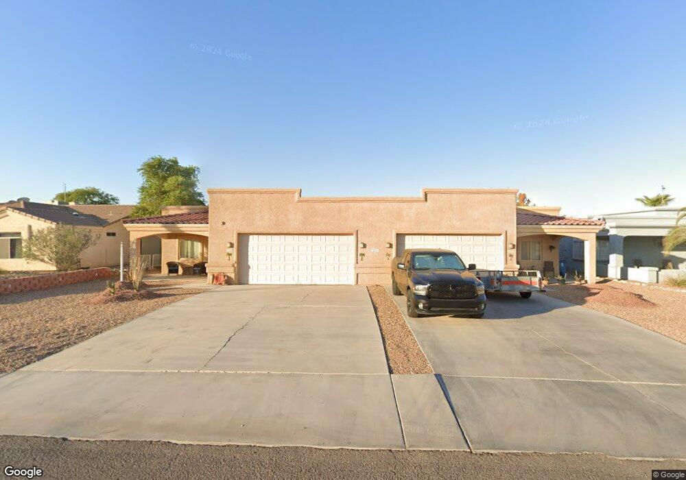
281 Cottonwood Dr Lake Havasu City, AZ 86403
Estimated Value: $567,000 - $901,089
--
Bed
4
Baths
3,202
Sq Ft
$242/Sq Ft
Est. Value
About This Home
This home is located at 281 Cottonwood Dr, Lake Havasu City, AZ 86403 and is currently estimated at $774,522, approximately $241 per square foot. 281 Cottonwood Dr is a home located in Mohave County with nearby schools including Starline Elementary School, Thunderbolt Middle School, and Lake Havasu High School.
Ownership History
Date
Name
Owned For
Owner Type
Purchase Details
Closed on
Feb 28, 2022
Sold by
Hagny Dennis W and Hagny Mary L
Bought by
Hagny Dennis W and Ha Mary
Current Estimated Value
Purchase Details
Closed on
Dec 8, 2015
Sold by
Blake Richard and Blake Janice
Bought by
Hagny Dennis W and Hagny Mary L
Purchase Details
Closed on
Jun 12, 2012
Sold by
Blake Harry E and Blake Hanna R
Bought by
Blake Richard and Blake Janice
Purchase Details
Closed on
Oct 11, 2004
Sold by
Milone Mark and Tejpal Lorraine
Bought by
Blake Harry and Blake Hannah
Create a Home Valuation Report for This Property
The Home Valuation Report is an in-depth analysis detailing your home's value as well as a comparison with similar homes in the area
Home Values in the Area
Average Home Value in this Area
Purchase History
| Date | Buyer | Sale Price | Title Company |
|---|---|---|---|
| Hagny Dennis W | -- | None Listed On Document | |
| Hagny Dennis W | $380,000 | Pioneer Title Agency Inc | |
| Blake Richard | -- | None Available | |
| Blake Harry | $87,000 | First American Title Ins Co |
Source: Public Records
Tax History Compared to Growth
Tax History
| Year | Tax Paid | Tax Assessment Tax Assessment Total Assessment is a certain percentage of the fair market value that is determined by local assessors to be the total taxable value of land and additions on the property. | Land | Improvement |
|---|---|---|---|---|
| 2026 | $1,364 | -- | -- | -- |
| 2025 | $2,764 | $0 | $0 | $0 |
| 2024 | $2,764 | $77,750 | $0 | $0 |
| 2023 | $2,764 | $50,384 | $0 | $0 |
| 2022 | $2,646 | $45,834 | $0 | $0 |
| 2021 | $2,840 | $34,854 | $0 | $0 |
| 2019 | $2,694 | $32,530 | $0 | $0 |
| 2018 | $2,600 | $32,818 | $0 | $0 |
| 2017 | $2,574 | $38,154 | $0 | $0 |
| 2016 | $2,324 | $36,307 | $0 | $0 |
| 2015 | $2,224 | $25,002 | $0 | $0 |
Source: Public Records
Map
Nearby Homes
- 1958 Montana Vista Unit D
- 190 Aspen Dr
- 1852 Montana Vista Unit B
- 1884 Montana Vista Unit 63B
- 1840 Montana Vista Unit D
- 371 Cottonwood Dr
- 1838 Montana Vista Unit C
- 160 Aspen Dr
- 1827 Combat Dr
- 1824 Montana Vista Unit D
- 220 White Oak Dr
- 1793 Montana Vista Unit C
- 1786 Los Lagos Dr Unit A
- 1962 Cliffrose Dr
- 1723 Montana Vista Unit D
- 1771 Los Lagos Dr Unit D
- 1775 Los Lagos Dr Unit B
- 1939 Pine Ln
- 1711 Combat Dr Unit 12
- 72 Mariposa Dr Unit D
- 281 Cottonwood Dr
- 271 Cottonwood Dr
- 291 Cottonwood Dr
- 1936 Montana Vista
- 1940 Montana Vista Unit C
- 1940 Montana Vista Unit 57C
- 1938 Montana Vista Unit 57B
- 1942 Montana Vista Unit D
- 1928 Montana Vista Unit 58A
- 1930 Montana Vista Unit 58B
- 261 Cottonwood Dr
- 301 Cottonwood Dr
- 220 Aspen Dr
- 1948 Montana Vista Unit C
- 1948 Montana Vista Unit 1948 C
- 1932 Montana Vista Unit 58C
- 1932 Montana Vista Unit C58
- 1932 Montana Vista Unit C
- 1944 Montana Vista Unit 56A
- 1944 Montana Vista Unit A