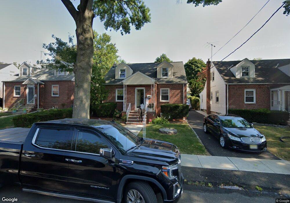
281 Herbert Ave Hillside, NJ 07205
Estimated Value: $458,097 - $577,000
Studio
--
Bath
2,066
Sq Ft
$252/Sq Ft
Est. Value
About This Home
This home is located at 281 Herbert Ave, Hillside, NJ 07205 and is currently estimated at $521,274, approximately $252 per square foot. 281 Herbert Ave is a home located in Union County with nearby schools including Abram P. Morris-Saybrook Elementary School, Hurden Looker School, and Ola Edwards Community School.
Ownership History
Date
Name
Owned For
Owner Type
Purchase Details
Closed on
Mar 15, 2006
Sold by
Johnson Donald
Bought by
Williams Debra Y Mc Carthy
Current Estimated Value
Home Financials for this Owner
Home Financials are based on the most recent Mortgage that was taken out on this home.
Original Mortgage
$271,200
Outstanding Balance
$153,307
Interest Rate
6.27%
Estimated Equity
$367,967
Purchase Details
Closed on
Sep 30, 1996
Sold by
Tortoriello Frances C
Bought by
Johnson Donald and Ferrell Alicia A
Create a Home Valuation Report for This Property
The Home Valuation Report is an in-depth analysis detailing your home's value as well as a comparison with similar homes in the area
Home Values in the Area
Average Home Value in this Area
Purchase History
| Date | Buyer | Sale Price | Title Company |
|---|---|---|---|
| Williams Debra Y Mc Carthy | $339,000 | -- | |
| Johnson Donald | $135,000 | First American |
Source: Public Records
Mortgage History
| Date | Status | Borrower | Loan Amount |
|---|---|---|---|
| Open | Williams Debra Y Mc Carthy | $271,200 |
Source: Public Records
Tax History
| Year | Tax Paid | Tax Assessment Tax Assessment Total Assessment is a certain percentage of the fair market value that is determined by local assessors to be the total taxable value of land and additions on the property. | Land | Improvement |
|---|---|---|---|---|
| 2025 | $9,491 | $115,000 | $58,100 | $56,900 |
| 2024 | $9,215 | $115,000 | $58,100 | $56,900 |
| 2023 | $9,215 | $115,000 | $58,100 | $56,900 |
| 2022 | $9,130 | $115,000 | $58,100 | $56,900 |
| 2021 | $9,070 | $115,000 | $58,100 | $56,900 |
| 2020 | $9,017 | $115,000 | $58,100 | $56,900 |
| 2019 | $8,842 | $115,000 | $58,100 | $56,900 |
| 2018 | $8,754 | $115,000 | $58,100 | $56,900 |
| 2017 | $8,701 | $115,000 | $58,100 | $56,900 |
| 2016 | $8,691 | $115,000 | $58,100 | $56,900 |
| 2015 | $8,614 | $115,000 | $58,100 | $56,900 |
| 2014 | $8,478 | $115,000 | $58,100 | $56,900 |
Source: Public Records
Map
Nearby Homes
- 260 Millard Ave
- 222 Boston Ave
- 359 Harvard Ave
- 386 Yale Ave
- 149 Baltimore Ave
- 128 Baltimore Ave
- 525 Us Highway 22
- 600 Plymouth Rd
- 537 Us Highway 22
- 542 Leo St
- 1393 Cornell Place
- 339 Hillside Ave
- 339 Hillside Ave Unit 2
- 1414 Boa Place Unit 2
- 1426 Franklin St
- 564 Chapman St
- 1442 Highland Ave
- 420 Hollywood Ave
- 1406 Maple Ave
- 130 Valley View Rd
- 277 Herbert Ave
- 285 Herbert Ave
- 289 Herbert Ave
- 273 Herbert Ave
- 284 Millard Ave
- 288 Millard Ave
- 280 Millard Ave
- 292 Millard Ave
- 269 Herbert Ave
- 276 Millard Ave
- 280 Herbert Ave
- 272 Millard Ave
- 276 Herbert Ave
- 265 Herbert Ave
- 274 Herbert Ave
- 270 Herbert Ave
- 270 Herbert Ave Unit 1
- 270 Herbert Ave
- 268 Millard Ave
- 1219 Liberty Ave
Your Personal Tour Guide
Ask me questions while you tour the home.