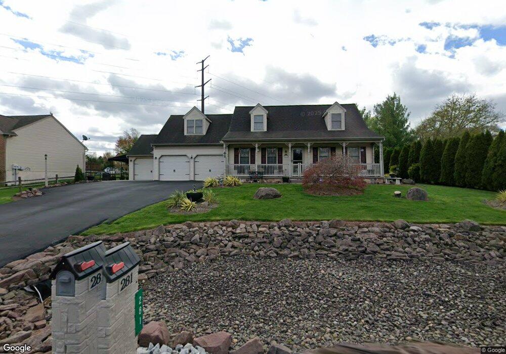
281 Lauschtown Rd Denver, PA 17517
Estimated Value: $428,000 - $487,000
3
Beds
2
Baths
2,046
Sq Ft
$223/Sq Ft
Est. Value
About This Home
This home is located at 281 Lauschtown Rd, Denver, PA 17517 and is currently estimated at $456,840, approximately $223 per square foot. 281 Lauschtown Rd is a home located in Lancaster County with nearby schools including Garden Spot Middle School, Garden Spot Senior High School, and Gehmans Mennonite School.
Ownership History
Date
Name
Owned For
Owner Type
Purchase Details
Closed on
Oct 22, 2001
Sold by
Martin Delmar P
Bought by
Stancavage Benjamin R and Stancavage Judith
Current Estimated Value
Home Financials for this Owner
Home Financials are based on the most recent Mortgage that was taken out on this home.
Original Mortgage
$72,000
Outstanding Balance
$28,122
Interest Rate
6.86%
Estimated Equity
$428,718
Create a Home Valuation Report for This Property
The Home Valuation Report is an in-depth analysis detailing your home's value as well as a comparison with similar homes in the area
Home Values in the Area
Average Home Value in this Area
Purchase History
| Date | Buyer | Sale Price | Title Company |
|---|---|---|---|
| Stancavage Benjamin R | $156,900 | -- |
Source: Public Records
Mortgage History
| Date | Status | Borrower | Loan Amount |
|---|---|---|---|
| Open | Stancavage Benjamin R | $72,000 |
Source: Public Records
Tax History Compared to Growth
Tax History
| Year | Tax Paid | Tax Assessment Tax Assessment Total Assessment is a certain percentage of the fair market value that is determined by local assessors to be the total taxable value of land and additions on the property. | Land | Improvement |
|---|---|---|---|---|
| 2025 | $4,610 | $267,900 | $57,200 | $210,700 |
| 2024 | $4,610 | $267,900 | $57,200 | $210,700 |
| 2023 | $4,516 | $267,900 | $57,200 | $210,700 |
| 2022 | $4,438 | $267,900 | $57,200 | $210,700 |
| 2021 | $4,216 | $267,900 | $57,200 | $210,700 |
| 2020 | $4,216 | $267,900 | $57,200 | $210,700 |
| 2019 | $4,167 | $267,900 | $57,200 | $210,700 |
| 2018 | $4,964 | $267,900 | $57,200 | $210,700 |
| 2017 | $2,859 | $150,100 | $32,900 | $117,200 |
| 2016 | $2,859 | $150,100 | $32,900 | $117,200 |
| 2015 | $601 | $150,100 | $32,900 | $117,200 |
| 2014 | $2,099 | $150,100 | $32,900 | $117,200 |
Source: Public Records
Map
Nearby Homes
- 256 W Valley Rd
- 346 Aplomado St
- 01 W Valley Rd
- Westbrooke Plan at Hawk Valley Estates
- Callahan Plan at Hawk Valley Estates
- Silverbrooke Plan at Hawk Valley Estates
- Wesley Plan at Hawk Valley Estates
- Bridgemont Plan at Hawk Valley Estates
- Logan Plan at Hawk Valley Estates
- Brookfield Plan at Hawk Valley Estates
- Kingston Plan at Hawk Valley Estates
- Berkley Plan at Hawk Valley Estates
- Sullivan Plan at Hawk Valley Estates
- 4 Eagle Cir
- 117 Hawk Valley Ln Unit 105
- 1395 Bowmansville Rd Unit 40
- 114 Cedarwood Dr
- 154 W Maple Grove Rd
- 1286 Reading Rd Unit 10000
- 1286 Reading Rd Unit 2500
- 275 Lauschtown Rd
- 1354 Crestview Dr
- 273 Lauschtown Rd
- 303 Lauschtown Rd
- 1352 Crestview Dr
- 307 Lauschtown Rd
- 1386 Clearview Dr
- 292 Skyline Dr
- 1346 Crestview Dr
- 296 Skyline Dr
- 288 Skyline Dr
- 308 Lauschtown Rd
- 1384 Clearview Dr
- 284 Lauschtown Rd
- 282 Skyline Dr
- 280 Lauschtown Rd
- 1385 Clearview Dr
- 276 Elsie Ln
- 295 Skyline Dr
- 299 Skyline Dr