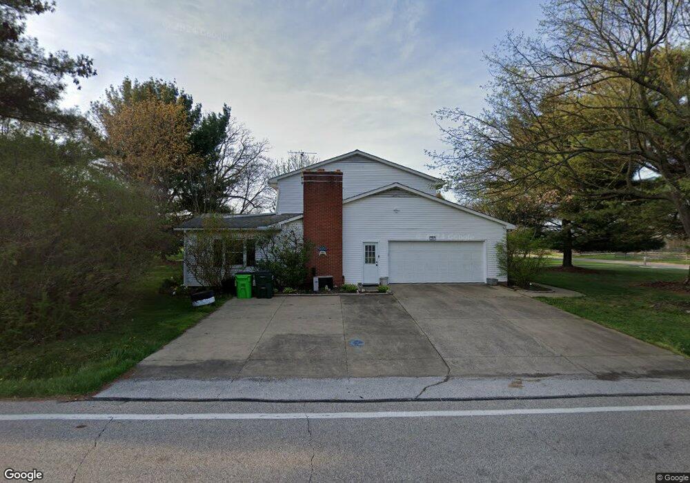
281 N Munroe Rd Tallmadge, OH 44278
Estimated Value: $296,000 - $344,000
4
Beds
3
Baths
1,932
Sq Ft
$169/Sq Ft
Est. Value
About This Home
This home is located at 281 N Munroe Rd, Tallmadge, OH 44278 and is currently estimated at $327,136, approximately $169 per square foot. 281 N Munroe Rd is a home located in Summit County with nearby schools including Tallmadge Middle School, Tallmadge High School, and Cornerstone Community School.
Ownership History
Date
Name
Owned For
Owner Type
Purchase Details
Closed on
Dec 8, 1997
Sold by
Tully Michael T
Bought by
Denning Bill E and Denning Ellen L
Current Estimated Value
Home Financials for this Owner
Home Financials are based on the most recent Mortgage that was taken out on this home.
Original Mortgage
$40,000
Outstanding Balance
$6,905
Interest Rate
7.46%
Mortgage Type
New Conventional
Estimated Equity
$320,231
Create a Home Valuation Report for This Property
The Home Valuation Report is an in-depth analysis detailing your home's value as well as a comparison with similar homes in the area
Home Values in the Area
Average Home Value in this Area
Purchase History
| Date | Buyer | Sale Price | Title Company |
|---|---|---|---|
| Denning Bill E | $165,000 | -- |
Source: Public Records
Mortgage History
| Date | Status | Borrower | Loan Amount |
|---|---|---|---|
| Open | Denning Bill E | $40,000 |
Source: Public Records
Tax History Compared to Growth
Tax History
| Year | Tax Paid | Tax Assessment Tax Assessment Total Assessment is a certain percentage of the fair market value that is determined by local assessors to be the total taxable value of land and additions on the property. | Land | Improvement |
|---|---|---|---|---|
| 2025 | $12,326 | $97,024 | $18,953 | $78,071 |
| 2024 | $4,949 | $97,024 | $18,953 | $78,071 |
| 2023 | $12,326 | $97,024 | $18,953 | $78,071 |
| 2022 | $4,153 | $66,574 | $12,982 | $53,592 |
| 2021 | $4,172 | $66,574 | $12,982 | $53,592 |
| 2020 | $4,140 | $66,570 | $12,980 | $53,590 |
| 2019 | $4,386 | $63,050 | $12,980 | $50,070 |
| 2018 | $3,876 | $63,050 | $12,980 | $50,070 |
| 2017 | $3,315 | $63,050 | $12,980 | $50,070 |
| 2016 | $3,569 | $53,360 | $12,980 | $40,380 |
| 2015 | $3,315 | $53,360 | $12,980 | $40,380 |
| 2014 | $2,678 | $53,360 | $12,980 | $40,380 |
| 2013 | $2,638 | $53,500 | $12,980 | $40,520 |
Source: Public Records
Map
Nearby Homes
- 617 Northeast Ave
- 313 Whittlesey Dr
- 0 Northeast Ave Unit 5114314
- 0 East Ave
- 557 Wring Dr
- 185 Reserve Dr
- 1072 Carol Ln
- 243 S Munroe Rd
- 206 Fawnwood Dr
- 213 Green Hill Dr
- 1029 Maple St
- 288 S Munroe Rd
- 98 Benjamin Way
- 988 Beechwood Dr
- 1168 East Ave
- 43 Benjamin Way
- 315 Fawnwood Dr
- Aspire Plan at Tallmadge Reserve
- Fairview Plan at Tallmadge Reserve
- Crisfield Plan at Tallmadge Reserve
- 291 N Munroe Rd
- 179 Willson Ave
- 195 Willson Ave
- 261 N Munroe Rd
- 206 Willson Ave
- 205 Willson Ave
- 325 N Munroe Rd
- 216 Willson Ave
- 251 N Munroe Rd
- 56 Barnes Dr
- 215 Willson Ave
- 66 Barnes Dr
- 226 Willson Ave
- 341 N Munroe Rd
- 461 Victoria Park Dr
- 76 Barnes Dr
- 225 Willson Ave
- 235 N Munroe Rd
- 449 Victoria Park Dr
- 236 Willson Ave