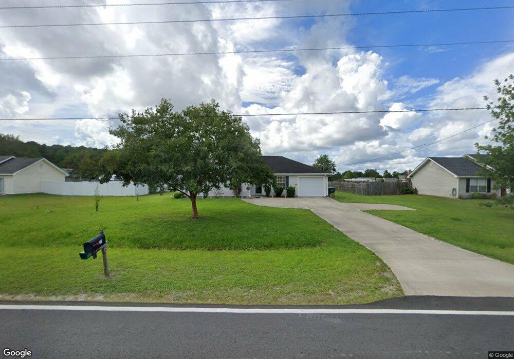
281 Ratcliffe Rd Brunswick, GA 31523
Estimated Value: $258,000 - $277,000
3
Beds
2
Baths
1,508
Sq Ft
$176/Sq Ft
Est. Value
About This Home
This home is located at 281 Ratcliffe Rd, Brunswick, GA 31523 and is currently estimated at $264,965, approximately $175 per square foot. 281 Ratcliffe Rd is a home located in Glynn County with nearby schools including Satilla Marsh Elementary School, Risley Middle School, and Glynn Academy.
Ownership History
Date
Name
Owned For
Owner Type
Purchase Details
Closed on
Sep 15, 2016
Sold by
Diane
Bought by
Johnson Harriett E and Millard Rushing Special Needs
Current Estimated Value
Purchase Details
Closed on
Dec 9, 2005
Sold by
Thornton Marlon
Bought by
Farmer Diane I and Farmer Frank J
Home Financials for this Owner
Home Financials are based on the most recent Mortgage that was taken out on this home.
Original Mortgage
$40,000
Interest Rate
5.85%
Mortgage Type
New Conventional
Create a Home Valuation Report for This Property
The Home Valuation Report is an in-depth analysis detailing your home's value as well as a comparison with similar homes in the area
Home Values in the Area
Average Home Value in this Area
Purchase History
| Date | Buyer | Sale Price | Title Company |
|---|---|---|---|
| Johnson Harriett E | $115,000 | -- | |
| Farmer Diane I | $115,000 | -- |
Source: Public Records
Mortgage History
| Date | Status | Borrower | Loan Amount |
|---|---|---|---|
| Previous Owner | Farmer Diane I | $40,000 |
Source: Public Records
Tax History Compared to Growth
Tax History
| Year | Tax Paid | Tax Assessment Tax Assessment Total Assessment is a certain percentage of the fair market value that is determined by local assessors to be the total taxable value of land and additions on the property. | Land | Improvement |
|---|---|---|---|---|
| 2025 | $2,073 | $82,640 | $9,000 | $73,640 |
| 2024 | $2,139 | $85,280 | $9,000 | $76,280 |
| 2023 | $852 | $85,280 | $9,000 | $76,280 |
| 2022 | $1,257 | $64,400 | $4,800 | $59,600 |
| 2021 | $1,293 | $54,840 | $3,400 | $51,440 |
| 2020 | $1,303 | $50,160 | $3,400 | $46,760 |
| 2019 | $1,303 | $50,160 | $3,400 | $46,760 |
| 2018 | $1,435 | $50,160 | $3,400 | $46,760 |
| 2017 | $1,312 | $45,480 | $3,400 | $42,080 |
| 2016 | $1,125 | $41,680 | $7,200 | $34,480 |
| 2015 | $1,129 | $41,680 | $7,200 | $34,480 |
| 2014 | $1,129 | $41,680 | $7,200 | $34,480 |
Source: Public Records
Map
Nearby Homes
- 546 Emanuel Church Rd
- 532 Emanuel Church Rd
- 115 Silver Bluff Dr
- 93 Silver Bluff Dr
- 117 Rachel Way
- 110 Rachel Way
- 0 Highway 82 Hwy Unit 25297888
- 36 Carlee Ln
- 40 Jada Ln
- 224 Oyster Cir
- 145 Oyster Rd
- 261 & 245 Fish Hall Rd
- 993 Myers Hill Rd
- 126 Cains Trace
- 0 Timber Landing Rd Unit 1654683
- 23 Superior Dr
- 190 Lakes Dr
- 154 Tison Dr
- 133 Huron Loop
- 1042 Lakes Dr
- 281 Ratcliffe Rd
- 289 Ratcliffe Rd
- 289 Ratcliffe Rd
- 259 Ratcliffe Rd
- 297 Ratcliffe Rd
- 297 Ratcliffe Rd
- 606 Emanuel Church Rd
- 286 Ratcliffe Rd
- 255 Ratcliffe Rd
- 258 Ratcliffe Rd
- 127 Ratcliff Rd
- 109 Avondale Rd
- 614 Emanuel Church Rd
- 258 Ratcliffe Rd
- 296 Ratcliffe Rd
- 296 Ratcliffe Rd
- 622 Emanuel Church Rd
- 311 Ratcliffe Rd
- 115 Avondale Rd
- 574 Emanuel Church Rd