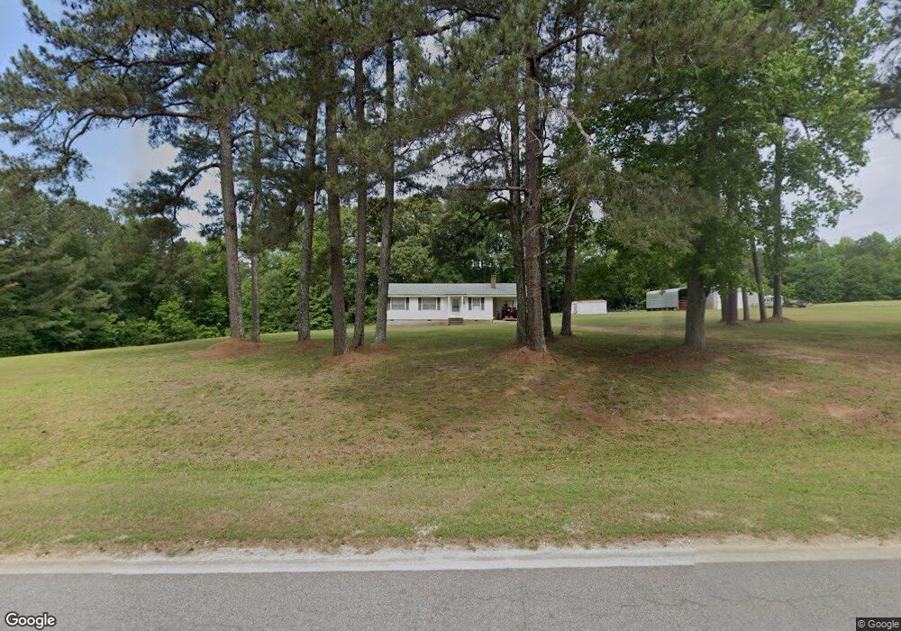
2813 Bartram Trace Rd Washington, GA 30673
Estimated Value: $146,000 - $239,366
3
Beds
2
Baths
1,148
Sq Ft
$168/Sq Ft
Est. Value
About This Home
This home is located at 2813 Bartram Trace Rd, Washington, GA 30673 and is currently estimated at $193,092, approximately $168 per square foot. 2813 Bartram Trace Rd is a home located in Wilkes County with nearby schools including Washington-Wilkes Elementary School, Washington-Wilkes Primary School, and Washington-Wilkes Middle School.
Ownership History
Date
Name
Owned For
Owner Type
Purchase Details
Closed on
May 9, 2019
Sold by
Ogletree Thomas David
Bought by
Bryant Karen O and Ogletree Randall D
Current Estimated Value
Purchase Details
Closed on
Jun 11, 2014
Sold by
Ogletree Frances Hardy
Bought by
Harby Everett W
Purchase Details
Closed on
May 1, 1984
Bought by
Ogletree Frances Har
Purchase Details
Closed on
Jan 1, 1972
Create a Home Valuation Report for This Property
The Home Valuation Report is an in-depth analysis detailing your home's value as well as a comparison with similar homes in the area
Purchase History
| Date | Buyer | Sale Price | Title Company |
|---|---|---|---|
| Bryant Karen O | -- | -- | |
| Bryant Karen O | -- | -- | |
| Harby Everett W | -- | -- | |
| Ogletree Frances Har | -- | -- | |
| -- | -- | -- |
Source: Public Records
Tax History
| Year | Tax Paid | Tax Assessment Tax Assessment Total Assessment is a certain percentage of the fair market value that is determined by local assessors to be the total taxable value of land and additions on the property. | Land | Improvement |
|---|---|---|---|---|
| 2025 | $1,402 | $49,286 | $19,890 | $29,396 |
| 2024 | $1,391 | $48,074 | $19,890 | $28,184 |
| 2023 | $1,368 | $48,074 | $19,890 | $28,184 |
| 2022 | $1,368 | $48,074 | $19,890 | $28,184 |
| 2021 | $1,401 | $48,074 | $19,890 | $28,184 |
| 2020 | $1,426 | $48,074 | $19,890 | $28,184 |
| 2019 | $63 | $2,112 | $2,112 | $0 |
| 2018 | $61 | $2,112 | $2,112 | $0 |
| 2017 | $61 | $2,112 | $2,112 | $0 |
| 2016 | $61 | $2,112 | $2,112 | $0 |
| 2015 | -- | $2,112 | $2,112 | $5,761 |
| 2014 | -- | $10,054 | $4,293 | $5,761 |
| 2013 | -- | $10,054 | $4,293 | $5,760 |
Source: Public Records
Map
Nearby Homes
- 0 Thaxton Rd Unit 10696641
- 0 Bartram Trace Rd
- 0 Bartram Trace Rd Unit 10677883
- 5111 Greensboro Rd
- 2242 Crawfordville Rd
- 0 Quaker Springs Rd Unit 10691164
- 1044 Sardis Rd
- 2514 Greensboro Rd
- 310 Philomath Woodville Rd
- 732 Hilliard Station Rd
- 520 Jackson St
- 403 Jackson St
- 402 Peachtree St
- 625 Happy Hollow Rd
- 0 Silas Mercer Rd NE Unit 10364766
- 203 Peter St
- Lot D Newtown Rd
- Lot C Newtown Rd
- Lot B Newtown Rd
- Lot E Newtown Rd
- 2893 Bartram Trace Rd
- 2813 Bartram Trace Rd
- 1579 Court Ground Rd
- 2737 Bartram Trace Rd
- 2229 Court Ground Rd
- 1947 Court Ground Rd
- 1947 Court Ground Rd
- 2226 Court Ground Rd
- 2629 Bartram Trace Rd
- 2532 Bartram Trace Rd
- 2336 Court Ground Rd
- 2076 Court Ground Rd
- 2575 Bartram Trace Rd
- 0 Thaxton Rd Unit CM969897
- 0 Thaxton Rd Unit CM971212
- 0 Thaxton Rd Unit 970987
- 0 Thaxton Rd Unit 8647321
- 0 Thaxton Rd Unit 8611774
- 1167 Sisson Bridges Rd
- 109 Thaxton Rd
Your Personal Tour Guide
Ask me questions while you tour the home.