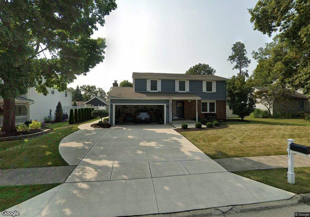
2813 Shadowood Dr Lima, OH 45805
Lakewood West NeighborhoodEstimated Value: $186,000 - $277,000
4
Beds
3
Baths
2,192
Sq Ft
$114/Sq Ft
Est. Value
About This Home
This home is located at 2813 Shadowood Dr, Lima, OH 45805 and is currently estimated at $250,408, approximately $114 per square foot. 2813 Shadowood Dr is a home located in Allen County with nearby schools including Maplewood Elementary School, Elmwood Elementary School, and Shawnee Middle School.
Ownership History
Date
Name
Owned For
Owner Type
Purchase Details
Closed on
May 24, 2007
Sold by
Lane Richard Todd
Bought by
Long Stacy E
Current Estimated Value
Purchase Details
Closed on
Sep 30, 2002
Sold by
Cooke Ralph F
Bought by
Lane Richard T
Purchase Details
Closed on
Sep 1, 1994
Sold by
Sullivan Paul
Bought by
Cooke Ralph and Cooke Jacqueline
Home Financials for this Owner
Home Financials are based on the most recent Mortgage that was taken out on this home.
Original Mortgage
$99,000
Interest Rate
8.59%
Mortgage Type
New Conventional
Purchase Details
Closed on
Dec 1, 1978
Bought by
Sullivan Paul J
Create a Home Valuation Report for This Property
The Home Valuation Report is an in-depth analysis detailing your home's value as well as a comparison with similar homes in the area
Home Values in the Area
Average Home Value in this Area
Purchase History
| Date | Buyer | Sale Price | Title Company |
|---|---|---|---|
| Long Stacy E | $100,000 | None Available | |
| Lane Richard T | $100,000 | -- | |
| Cooke Ralph | $110,000 | -- | |
| Sullivan Paul J | $69,500 | -- |
Source: Public Records
Mortgage History
| Date | Status | Borrower | Loan Amount |
|---|---|---|---|
| Previous Owner | Cooke Ralph | $99,000 |
Source: Public Records
Tax History
| Year | Tax Paid | Tax Assessment Tax Assessment Total Assessment is a certain percentage of the fair market value that is determined by local assessors to be the total taxable value of land and additions on the property. | Land | Improvement |
|---|---|---|---|---|
| 2024 | $2,716 | $67,830 | $9,030 | $58,800 |
| 2023 | $2,648 | $60,030 | $7,980 | $52,050 |
| 2022 | $2,671 | $60,030 | $7,980 | $52,050 |
| 2021 | $2,686 | $60,030 | $7,980 | $52,050 |
| 2020 | $2,358 | $56,070 | $7,560 | $48,510 |
| 2019 | $2,358 | $56,070 | $7,560 | $48,510 |
| 2018 | $2,349 | $56,070 | $7,560 | $48,510 |
| 2017 | $2,400 | $56,070 | $7,560 | $48,510 |
| 2016 | $2,376 | $56,070 | $7,560 | $48,510 |
| 2015 | $2,374 | $56,070 | $7,560 | $48,510 |
| 2014 | $2,258 | $52,680 | $7,810 | $44,870 |
| 2013 | $2,209 | $52,680 | $7,810 | $44,870 |
Source: Public Records
Map
Nearby Homes
- 2921 Canterbury Dr
- 2949 Lakewood Ave
- 2964 Hanover Dr
- 2802 Lowell Ave
- 2700 Lowell Ave
- 2997 Cletus Pkwy
- 3071 Canterbury Dr
- 250 Squire Ln
- XXXX Spencerville Rd
- 1880 Wendell Ave
- 2072 Arcadia Ave
- 161 S Cable Rd
- 0 Springview Dr
- 2250 Kunneke Ave
- 1421 Shawnee Rd
- 3360 Springview Dr
- 2201 W High St
- 1409 Fulton Rd
- 906 Daniels Ave
- 1408 Winghaven Dr
- 2819 Shadowood Dr
- 2807 Shadowood Dr
- 2812 Chapel Hill Dr
- 2818 Chapel Hill Dr
- 2812 Shadowood Dr
- 2818 Shadowood Dr
- 2824 Chapel Hill Dr
- 2806 Shadowood Dr
- 2824 Shadowood Dr
- 2831 Shadowood Dr
- 731 Bentwood Dr
- 737 Bentwood Ave
- 2830 Chapel Hill Dr
- 737 Bentwood Dr
- 725 Bentwood Dr
- 2830 Shadowood Dr
- 743 Bentwood Dr
- 702 Bentwood Dr
Your Personal Tour Guide
Ask me questions while you tour the home.