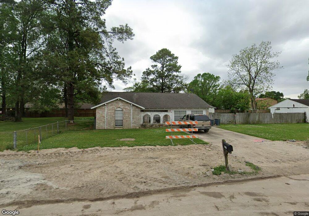
2814 Bluerock St Houston, TX 77039
East Aldine NeighborhoodEstimated Value: $297,000 - $346,230
3
Beds
2
Baths
1,750
Sq Ft
$182/Sq Ft
Est. Value
About This Home
This home is located at 2814 Bluerock St, Houston, TX 77039 and is currently estimated at $318,058, approximately $181 per square foot. 2814 Bluerock St is a home located in Harris County with nearby schools including Hinojosa EC/PK/K, Raymond Academy, and Mead Middle.
Ownership History
Date
Name
Owned For
Owner Type
Purchase Details
Closed on
Apr 4, 2006
Sold by
Lavender Mary Sue Camario and Lavender Fred W
Bought by
Leal David R and Leal Monica S
Current Estimated Value
Home Financials for this Owner
Home Financials are based on the most recent Mortgage that was taken out on this home.
Original Mortgage
$120,000
Outstanding Balance
$77,904
Interest Rate
8.72%
Mortgage Type
Fannie Mae Freddie Mac
Estimated Equity
$240,154
Purchase Details
Closed on
Oct 11, 2001
Sold by
Monterrey George Gilbert and Leal Monica Monterrey
Bought by
Lavender Mary Sue Camario
Create a Home Valuation Report for This Property
The Home Valuation Report is an in-depth analysis detailing your home's value as well as a comparison with similar homes in the area
Home Values in the Area
Average Home Value in this Area
Purchase History
| Date | Buyer | Sale Price | Title Company |
|---|---|---|---|
| Leal David R | -- | Alamo Title | |
| Lavender Mary Sue Camario | -- | -- |
Source: Public Records
Mortgage History
| Date | Status | Borrower | Loan Amount |
|---|---|---|---|
| Open | Leal David R | $120,000 |
Source: Public Records
Tax History Compared to Growth
Tax History
| Year | Tax Paid | Tax Assessment Tax Assessment Total Assessment is a certain percentage of the fair market value that is determined by local assessors to be the total taxable value of land and additions on the property. | Land | Improvement |
|---|---|---|---|---|
| 2025 | $3,436 | $348,704 | $198,288 | $150,416 |
| 2024 | $3,436 | $349,147 | $198,288 | $150,859 |
| 2023 | $3,436 | $349,147 | $198,288 | $150,859 |
| 2022 | $4,210 | $236,248 | $139,536 | $96,712 |
| 2021 | $4,012 | $186,122 | $68,299 | $117,823 |
| 2020 | $4,228 | $186,122 | $68,299 | $117,823 |
| 2019 | $4,428 | $186,122 | $68,299 | $117,823 |
| 2018 | $2,118 | $186,122 | $73,440 | $112,682 |
| 2017 | $3,554 | $186,122 | $73,440 | $112,682 |
| 2016 | $3,231 | $156,000 | $73,440 | $82,560 |
| 2015 | $2,279 | $0 | $0 | $0 |
| 2014 | $2,279 | $117,829 | $38,999 | $78,830 |
Source: Public Records
Map
Nearby Homes
- 2710 Woodgate St
- 2703 Lauder Rd
- 2715 Toyah Ave
- 2611 Lauder Rd
- 0 Lauder Rd
- 2807 Verhalen Ave
- 2438 Balmorhea Ave
- 2434 Balmorhea Ave
- 3503 Debeney Dr
- 12123 Steeple Ln
- 4002 Charriton Dr
- 4422 Sandydale Ln
- 4542 Hollybrook Ln
- 1810 Connorvale Rd
- 13310 Robertcrest St Unit B
- 1826 Gault Rd
- 1720 Strawn Rd
- 1730 Strawn Rd
- 1916 Gault Rd
- 1725 Strawn Rd
- 2815 Connorvale Rd
- 2815 Connorvale Rd
- 2823 Connorvale Rd
- 2806 Bluerock St
- 2815 Bluerock St
- 16214 Bluerock St
- 2823 Bluerock St
- 2818 Ridgeland Ave
- 2807 Bluerock St
- 13510 Rockshire Dr
- 13514 Rockshire Dr
- 13502 Rockshire Dr
- 13518 Rockshire Dr
- 2822 Connorvale Rd
- 2814 Ridgeland Ave
- 2814 Ridgeland Ave
- 2727 Bluerock St
- 2727 Bluerock St
- 2814 Connorvale Rd
- 2822 Ridgeland Ave