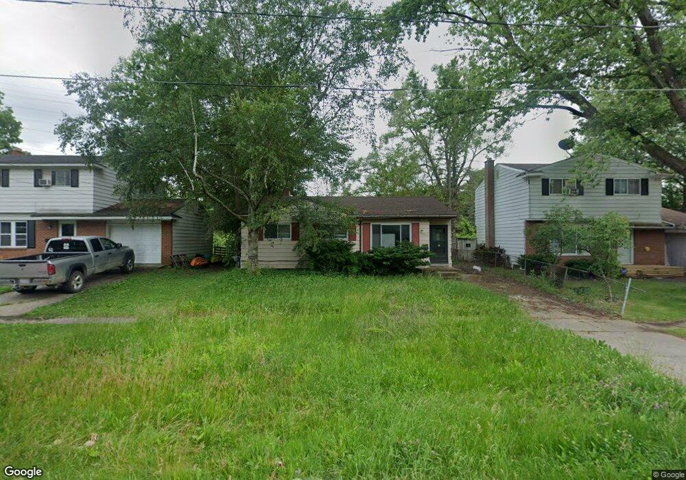
2814 E Pierson Rd Flint, MI 48506
Northeast Flint NeighborhoodEstimated Value: $60,000 - $69,000
3
Beds
1
Bath
964
Sq Ft
$66/Sq Ft
Est. Value
About This Home
This home is located at 2814 E Pierson Rd, Flint, MI 48506 and is currently estimated at $63,642, approximately $66 per square foot. 2814 E Pierson Rd is a home located in Genesee County with nearby schools including Brownell STEM Academy, Richfield Public School Academy, and Richfield Early Learning Center.
Ownership History
Date
Name
Owned For
Owner Type
Purchase Details
Closed on
Dec 8, 2016
Sold by
Katola Jonathan M
Bought by
Home I Llc
Current Estimated Value
Purchase Details
Closed on
Jan 12, 2007
Sold by
Washington Mutual Bank Fa
Bought by
Hud
Purchase Details
Closed on
Feb 14, 2005
Sold by
Fisher Delphia and Fisher Carol A
Bought by
Davidson Donna
Create a Home Valuation Report for This Property
The Home Valuation Report is an in-depth analysis detailing your home's value as well as a comparison with similar homes in the area
Home Values in the Area
Average Home Value in this Area
Purchase History
| Date | Buyer | Sale Price | Title Company |
|---|---|---|---|
| Home I Llc | -- | None Available | |
| Hud | -- | None Available | |
| Davidson Donna | $56,000 | Sargents Title Company |
Source: Public Records
Tax History
| Year | Tax Paid | Tax Assessment Tax Assessment Total Assessment is a certain percentage of the fair market value that is determined by local assessors to be the total taxable value of land and additions on the property. | Land | Improvement |
|---|---|---|---|---|
| 2025 | $1,082 | $24,400 | $0 | $0 |
| 2024 | $1,003 | $20,700 | $0 | $0 |
| 2023 | $982 | $17,200 | $0 | $0 |
| 2022 | $0 | $12,300 | $0 | $0 |
| 2021 | $994 | $12,500 | $0 | $0 |
| 2020 | $916 | $9,900 | $0 | $0 |
| 2019 | $953 | $10,600 | $0 | $0 |
| 2018 | $968 | $10,700 | $0 | $0 |
| 2017 | $1,062 | $0 | $0 | $0 |
| 2016 | $1,035 | $0 | $0 | $0 |
| 2015 | -- | $0 | $0 | $0 |
| 2014 | -- | $0 | $0 | $0 |
| 2012 | -- | $16,000 | $0 | $0 |
Source: Public Records
Map
Nearby Homes
- 2825 Eaton Place
- 2727 Eaton Place
- 4907 Delta Dr
- 4923 Alpha Way
- 4808 Alpha Way
- 5919 Western Rd
- 2919 Hampstead Dr
- 3364 E Pierson Rd
- 2935 Richfield Rd
- 3294 Huggins Ave
- 3456 E Pierson Rd
- 00 Richfield Rd
- 1704 E Webster Rd
- 3006 Agree Ave
- 5910 N Dort Hwy
- 4298 N Center Rd
- 4081 Hidden View Dr
- 3010 Wyoming Ave
- 3118 Wyoming Ave
- 3705 Aldon Ln
- 2810 E Pierson Rd
- 2818 E Pierson Rd
- 2806 E Pierson Rd
- 2822 E Pierson Rd
- 2826 E Pierson Rd
- 2802 E Pierson Rd
- 2813 E Pierson Rd
- 2817 E Pierson Rd
- 2809 E Pierson Rd
- 2734 E Pierson Rd
- 2830 E Pierson Rd
- 2821 E Pierson Rd
- 2805 E Pierson Rd
- 2813 Alpha Way
- 2829 Alpha Way
- 2825 E Pierson Rd
- 2801 E Pierson Rd
- 2809 Alpha Way
- 2730 E Pierson Rd
- 2834 E Pierson Rd
Your Personal Tour Guide
Ask me questions while you tour the home.