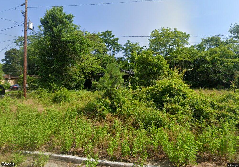
2816 Bertha Dr Macon, GA 31217
Estimated Value: $52,000 - $73,000
2
Beds
1
Bath
792
Sq Ft
$81/Sq Ft
Est. Value
About This Home
This home is located at 2816 Bertha Dr, Macon, GA 31217 and is currently estimated at $63,977, approximately $80 per square foot. 2816 Bertha Dr is a home located in Bibb County with nearby schools including Martin Luther King Jr. Elementary School, Appling Middle School, and Northeast High School.
Ownership History
Date
Name
Owned For
Owner Type
Purchase Details
Closed on
Jun 30, 2022
Sold by
Sfh69 Llc
Bought by
Macon Om Portfolio Llc
Current Estimated Value
Purchase Details
Closed on
Jun 28, 2019
Sold by
Mq Properties Llc
Bought by
Sfh69 Llc
Purchase Details
Closed on
Jun 27, 2019
Sold by
Macon 20 Llc
Bought by
Mq Properties Llc
Purchase Details
Closed on
Jul 10, 2013
Sold by
Neisler Jeff
Bought by
Macon 20 Llc
Purchase Details
Closed on
Feb 27, 2004
Bought by
Neisler Jeff
Purchase Details
Closed on
Mar 10, 2000
Purchase Details
Closed on
Mar 31, 1997
Create a Home Valuation Report for This Property
The Home Valuation Report is an in-depth analysis detailing your home's value as well as a comparison with similar homes in the area
Home Values in the Area
Average Home Value in this Area
Purchase History
| Date | Buyer | Sale Price | Title Company |
|---|---|---|---|
| Macon Om Portfolio Llc | -- | Smith Hawkins Hollingsworth & | |
| Sfh69 Llc | $2,000,000 | None Available | |
| Mq Properties Llc | $231,225 | None Available | |
| Macon 20 Llc | $450,000 | -- | |
| Neisler Jeff | $15,000 | -- | |
| -- | $31,000 | -- | |
| -- | $32,000 | -- |
Source: Public Records
Tax History Compared to Growth
Tax History
| Year | Tax Paid | Tax Assessment Tax Assessment Total Assessment is a certain percentage of the fair market value that is determined by local assessors to be the total taxable value of land and additions on the property. | Land | Improvement |
|---|---|---|---|---|
| 2025 | $383 | $15,595 | $3,540 | $12,055 |
| 2024 | $371 | $14,600 | $3,540 | $11,060 |
| 2023 | $318 | $12,504 | $2,550 | $9,954 |
| 2022 | $981 | $6,909 | $1,825 | $5,084 |
| 2021 | $263 | $6,909 | $1,825 | $5,084 |
| 2020 | $231 | $5,938 | $2,028 | $3,910 |
| 2019 | $232 | $5,938 | $2,028 | $3,910 |
| 2018 | $536 | $5,938 | $2,028 | $3,910 |
| 2017 | $222 | $5,938 | $2,028 | $3,910 |
| 2016 | $205 | $5,938 | $2,028 | $3,910 |
| 2015 | $291 | $5,938 | $2,028 | $3,910 |
| 2014 | $334 | $5,938 | $2,028 | $3,910 |
Source: Public Records
Map
Nearby Homes
- 2720 Jordan Ave
- 2675 Andy Dr
- 2954 Tyler Place
- 2370 Recreation Rd
- 2940 Shurling Dr
- 2750 Lakeshore Dr
- 3048 Bethune Ave
- 2229 New Clinton Rd
- 3145 Pasadena Dr
- 3128 Commodore Dr
- 2130 New Clinton Rd
- 860 Morningside Dr
- 2146 Melton Ave
- 2792 Skyline Dr
- 2066 Melton Ave
- 0 Shady Rd
- 2035 Fairway Dr
- 3154 Bethune Ave
- 1840 Kinder Kare Dr
- 875 Artic Cir
- 2807 Flewellyn Dr
- 2815 Flewellyn Dr
- 2813 Bertha Dr
- 2809 Flewellyn Dr
- 2831 Flewellyn Dr
- 2812 Hinsley Ave
- 2837 Flewellyn Dr
- 2806 Hinsley Ave
- 2820 Hinsley Ave
- 2845 Flewellyn Dr
- 2820 Flewellyn Dr
- 2811 Hinsley Ave
- 2820 Jordan Ave
- 2887 Flewellyn Dr
- 2855 Flewellyn Dr
- 2827 Hinsley Ave
- 2749 Mollie Dr
- 2787 Flewellyn Dr
- 2838 Century Place
- 2810 Century Place