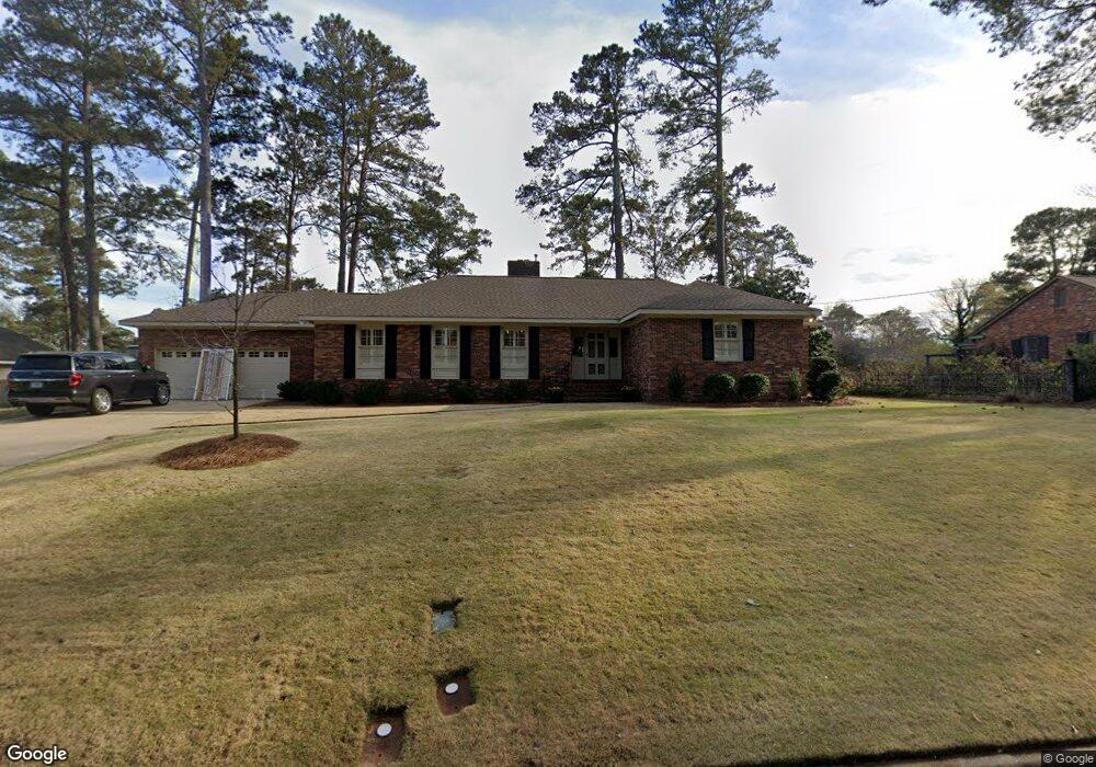
2818 Carson Dr Columbus, GA 31906
Wyntonn Grove NeighborhoodEstimated Value: $387,296 - $585,000
3
Beds
4
Baths
2,415
Sq Ft
$188/Sq Ft
Est. Value
About This Home
This home is located at 2818 Carson Dr, Columbus, GA 31906 and is currently estimated at $453,074, approximately $187 per square foot. 2818 Carson Dr is a home located in Muscogee County with nearby schools including Clubview Elementary School, Richards Middle School, and Hardaway High School.
Ownership History
Date
Name
Owned For
Owner Type
Purchase Details
Closed on
Apr 30, 2013
Sold by
Edwards Judith L
Bought by
Brown Dustin T
Current Estimated Value
Home Financials for this Owner
Home Financials are based on the most recent Mortgage that was taken out on this home.
Original Mortgage
$244,000
Outstanding Balance
$173,520
Interest Rate
3.56%
Mortgage Type
New Conventional
Estimated Equity
$279,554
Purchase Details
Closed on
Feb 16, 2009
Sold by
Edwards Ronald A
Bought by
Edwards Judith L
Home Financials for this Owner
Home Financials are based on the most recent Mortgage that was taken out on this home.
Original Mortgage
$248,000
Interest Rate
5.03%
Mortgage Type
Purchase Money Mortgage
Purchase Details
Closed on
Sep 25, 2007
Sold by
Edwards Ronald A
Bought by
Edwards Judith L
Create a Home Valuation Report for This Property
The Home Valuation Report is an in-depth analysis detailing your home's value as well as a comparison with similar homes in the area
Home Values in the Area
Average Home Value in this Area
Purchase History
| Date | Buyer | Sale Price | Title Company |
|---|---|---|---|
| Brown Dustin T | $305,000 | -- | |
| Edwards Judith L | -- | None Available | |
| Edwards Ronald A | -- | None Available | |
| Edwards Judith L | -- | None Available |
Source: Public Records
Mortgage History
| Date | Status | Borrower | Loan Amount |
|---|---|---|---|
| Open | Brown Dustin T | $244,000 | |
| Previous Owner | Edwards Ronald A | $248,000 |
Source: Public Records
Tax History Compared to Growth
Tax History
| Year | Tax Paid | Tax Assessment Tax Assessment Total Assessment is a certain percentage of the fair market value that is determined by local assessors to be the total taxable value of land and additions on the property. | Land | Improvement |
|---|---|---|---|---|
| 2025 | $4,260 | $137,464 | $28,092 | $109,372 |
| 2024 | $2,555 | $137,464 | $28,092 | $109,372 |
| 2023 | $2,155 | $137,464 | $28,092 | $109,372 |
| 2022 | $4,441 | $112,136 | $28,092 | $84,044 |
| 2021 | $4,435 | $109,452 | $28,092 | $81,360 |
| 2020 | $4,436 | $109,452 | $28,092 | $81,360 |
| 2019 | $4,452 | $109,452 | $28,092 | $81,360 |
| 2018 | $4,452 | $109,452 | $28,092 | $81,360 |
| 2017 | $4,468 | $109,452 | $28,092 | $81,360 |
| 2016 | $4,485 | $122,000 | $11,250 | $110,750 |
| 2015 | $4,491 | $122,000 | $11,250 | $110,750 |
| 2014 | $5,240 | $122,000 | $11,250 | $110,750 |
| 2013 | -- | $123,446 | $11,250 | $112,196 |
Source: Public Records
Map
Nearby Homes
- 2817 Carson Dr
- 2637 Sue MacK Dr
- 2604 Sue MacK Dr
- 2010 Wells Dr
- 2820 Nancy St
- 2576 Habersham Ave
- 2940 Birchfield Dr
- 1903 Marilon Dr
- 2609 Hilton Ave
- 2220 Country Club Rd
- 1714 Iris Dr
- 2930 Sue MacK Dr
- 1712 Marilon Dr
- 1806 Stark Ave
- 2917 Edgewood Rd
- 1706 Stark Ave
- 2722 E Lindsay Dr
- 1700 Stark Ave
- 1717 Stark Ave
- 1500 Preston Dr
- 2828 Carson Dr
- 2808 Carson Dr
- 2817 Averett Dr
- 2827 Averett Dr
- 2807 Averett Dr
- 2807 Carson Dr
- 2904 Carson Dr
- 2829 Carson Dr
- 2905 Averett Dr
- 2814 Averett Dr
- 2640 Carson Dr
- 2824 Averett Dr
- 2801 Carson Dr
- 2905 Carson Dr
- 2806 Averett Dr
- 2733 Averett Dr
- 2916 Carson Dr
- 2732 Techwood Dr
- 2710 Techwood Dr
- 2900 Averett Dr