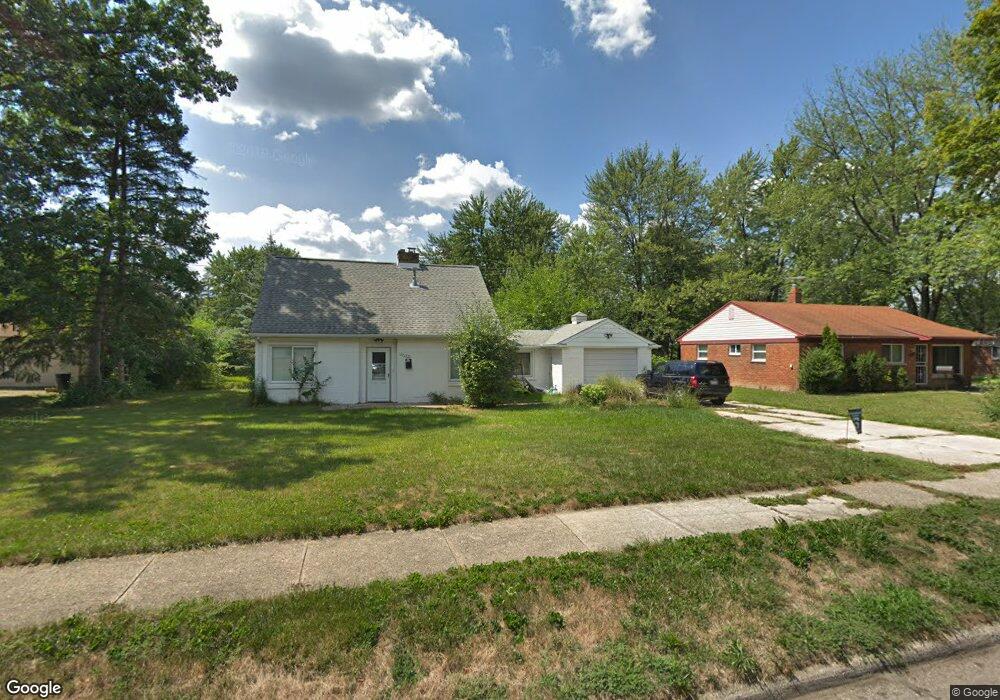
28195 Sutherland St Southfield, MI 48076
Estimated Value: $187,000 - $219,000
--
Bed
1
Bath
1,144
Sq Ft
$177/Sq Ft
Est. Value
About This Home
This home is located at 28195 Sutherland St, Southfield, MI 48076 and is currently estimated at $201,954, approximately $176 per square foot. 28195 Sutherland St is a home located in Oakland County with nearby schools including Vandenberg Elementary School, Thompson K-8 International Baccalaureate Academy, and Crescent Academy Pk-1.
Ownership History
Date
Name
Owned For
Owner Type
Purchase Details
Closed on
Apr 28, 2008
Sold by
Mosby Esther
Bought by
Mosby Esther and Mosby Lemmie L
Current Estimated Value
Purchase Details
Closed on
Jun 23, 2005
Sold by
Thomas Nathan Michael and Crochet Timothy
Bought by
Mosby Esther
Purchase Details
Closed on
Aug 13, 2002
Sold by
Piiranen Florence
Bought by
Thomas Nathan M
Home Financials for this Owner
Home Financials are based on the most recent Mortgage that was taken out on this home.
Original Mortgage
$57,000
Interest Rate
6.4%
Mortgage Type
Purchase Money Mortgage
Create a Home Valuation Report for This Property
The Home Valuation Report is an in-depth analysis detailing your home's value as well as a comparison with similar homes in the area
Home Values in the Area
Average Home Value in this Area
Purchase History
| Date | Buyer | Sale Price | Title Company |
|---|---|---|---|
| Mosby Esther | -- | None Available | |
| Mosby Esther | $97,000 | Title One Inc | |
| Thomas Nathan M | $57,000 | -- |
Source: Public Records
Mortgage History
| Date | Status | Borrower | Loan Amount |
|---|---|---|---|
| Previous Owner | Thomas Nathan M | $57,000 |
Source: Public Records
Tax History Compared to Growth
Tax History
| Year | Tax Paid | Tax Assessment Tax Assessment Total Assessment is a certain percentage of the fair market value that is determined by local assessors to be the total taxable value of land and additions on the property. | Land | Improvement |
|---|---|---|---|---|
| 2022 | $2,322 | $66,000 | $14,630 | $51,370 |
| 2021 | $1,783 | $53,580 | $9,350 | $44,230 |
| 2020 | $1,768 | $46,950 | $9,350 | $37,600 |
| 2018 | $1,844 | $36,470 | $9,350 | $27,120 |
| 2015 | -- | $30,910 | $0 | $0 |
| 2014 | -- | $25,590 | $0 | $0 |
| 2011 | -- | $26,360 | $0 | $0 |
Source: Public Records
Map
Nearby Homes
- 28080 Pierce St
- 28174 Sutherland St
- 28426 Sutherland St
- 28048 Pierce St
- 28060 Aberdeen St
- 28521 Sutherland St
- 28115 Everett St
- 28091 Everett St
- 28464 Stuart Ave
- 28405 Stuart Ave
- 27662 Shagbark Dr
- 28249 Red Leaf Ln
- 28580 Red Leaf Ln
- 15840 Catalpa Dr
- 27627 Lexington Pkwy
- 28530 Fairfax St
- 28723 Everett St
- 28775 Glasgow St
- 28760 Everett St
- 28466 Brentwood St
- 28203 Sutherland St
- 28089 Sutherland St
- 28104 Pierce St
- 28102 Pierce St
- 28211 Sutherland St
- 28081 Sutherland St
- 28294 Pierce St
- 28092 Pierce St
- 28196 Sutherland St
- 28190 Sutherland St
- 28202 Sutherland St
- 28304 Pierce St
- 28084 Pierce St
- 28186 Sutherland St
- 28319 Sutherland St
- 28206 Sutherland St
- 28073 Sutherland St
- 28178 Sutherland St
- 28214 Sutherland St
- 28316 Pierce St