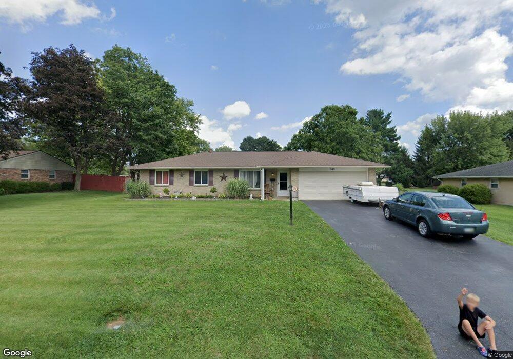
282 Bronston Trail Beavercreek, OH 45430
Estimated Value: $261,000 - $275,000
3
Beds
2
Baths
1,371
Sq Ft
$196/Sq Ft
Est. Value
About This Home
This home is located at 282 Bronston Trail, Beavercreek, OH 45430 and is currently estimated at $268,226, approximately $195 per square foot. 282 Bronston Trail is a home located in Greene County with nearby schools including Fairbrook Elementary School, Herman K Ankeney Middle School, and Beavercreek High School.
Ownership History
Date
Name
Owned For
Owner Type
Purchase Details
Closed on
Jul 27, 2019
Sold by
Donaldson Michele and Donaldson Justin
Bought by
Donaldson Michele
Current Estimated Value
Purchase Details
Closed on
May 2, 2018
Sold by
Louderback Daniel L and Louderback Diana
Bought by
Donaldson Michele and Donaldson Justin
Home Financials for this Owner
Home Financials are based on the most recent Mortgage that was taken out on this home.
Original Mortgage
$135,000
Outstanding Balance
$116,239
Interest Rate
4.4%
Mortgage Type
New Conventional
Estimated Equity
$151,987
Purchase Details
Closed on
Jul 23, 2012
Sold by
Sarvers Business Pa
Bought by
Louderback Daniel L and Louderback Diana
Home Financials for this Owner
Home Financials are based on the most recent Mortgage that was taken out on this home.
Original Mortgage
$120,000
Interest Rate
3.65%
Mortgage Type
New Conventional
Purchase Details
Closed on
Nov 22, 2011
Sold by
Osman Samuel Lee and Osman Sandra L
Bought by
Sarvers Business Partnership
Create a Home Valuation Report for This Property
The Home Valuation Report is an in-depth analysis detailing your home's value as well as a comparison with similar homes in the area
Home Values in the Area
Average Home Value in this Area
Purchase History
| Date | Buyer | Sale Price | Title Company |
|---|---|---|---|
| Donaldson Michele | -- | Mortgage Connect Lp | |
| Donaldson Michele | $150,000 | None Available | |
| Louderback Daniel L | $130,800 | None Available | |
| Sarvers Business Partnership | $70,000 | Attorney |
Source: Public Records
Mortgage History
| Date | Status | Borrower | Loan Amount |
|---|---|---|---|
| Open | Donaldson Michele | $135,000 | |
| Previous Owner | Louderback Daniel L | $120,000 |
Source: Public Records
Tax History Compared to Growth
Tax History
| Year | Tax Paid | Tax Assessment Tax Assessment Total Assessment is a certain percentage of the fair market value that is determined by local assessors to be the total taxable value of land and additions on the property. | Land | Improvement |
|---|---|---|---|---|
| 2024 | $4,608 | $70,580 | $12,080 | $58,500 |
| 2023 | $4,608 | $70,580 | $12,080 | $58,500 |
| 2022 | $3,911 | $52,880 | $10,500 | $42,380 |
| 2021 | $3,832 | $52,880 | $10,500 | $42,380 |
| 2020 | $3,861 | $52,880 | $10,500 | $42,380 |
| 2019 | $3,756 | $46,960 | $9,320 | $37,640 |
| 2018 | $3,315 | $46,960 | $9,320 | $37,640 |
| 2017 | $3,105 | $46,960 | $9,320 | $37,640 |
| 2016 | $3,106 | $42,620 | $9,320 | $33,300 |
| 2015 | $3,087 | $42,620 | $9,320 | $33,300 |
| 2014 | $3,041 | $42,620 | $9,320 | $33,300 |
Source: Public Records
Map
Nearby Homes
- 170 Saundra Ct
- 97 Apple Blossom Place
- 3961 Ephrata Ct
- 185 Rosillo Dr
- 65 Aberdeen Village Dr Unit 65
- 2658 Tompkins Dr
- 24 Rosell Dr
- 3978 Indian Ripple Rd
- 4174 White Hawk Ct
- 4134 Cambridge Trail
- 564 Plattner Trail
- 4310 Straight Arrow Rd Unit 4310
- 4324 Straight Arrow Rd Unit 4324
- 611 Cape Cod Ct
- 520 Vineland Trail
- 615 Bendwood Way
- 4011 Willow Run Dr
- 641 Angler Ct
- 4485 Longmeadow Ln
- 3917 E Summit Ridge Dr
- 266 Bronston Trail
- 281 Kenderton Trail
- 252 Bronston Trail
- 310 Bronston Trail
- 295 Kenderton Trail
- 265 Kenderton Trail
- 275 Bronston Trail
- 4112 Vineland Trail
- 251 Kenderton Trail
- 311 Kenderton Trail
- 261 Bronston Trail
- 242 Bronston Trail
- 322 Bronston Trail
- 311 Bronston Trail
- 241 Kenderton Trail
- 245 Bronston Trail
- 321 Kenderton Trail
- 321 Bronston Trail
- 234 Bronston Trail
- 332 Bronston Trail