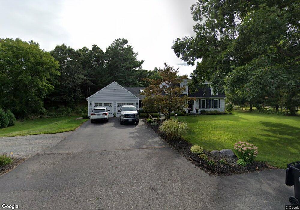
282 Thurston St Wrentham, MA 02093
Estimated Value: $678,000 - $787,000
3
Beds
3
Baths
2,144
Sq Ft
$341/Sq Ft
Est. Value
About This Home
This home is located at 282 Thurston St, Wrentham, MA 02093 and is currently estimated at $731,308, approximately $341 per square foot. 282 Thurston St is a home located in Norfolk County with nearby schools including Delaney Elementary School, Charles E Roderick, and Foxborough Regional Charter School.
Ownership History
Date
Name
Owned For
Owner Type
Purchase Details
Closed on
Jun 6, 2018
Sold by
Sepe Christopher A and Sepe Diane T
Bought by
Sepe Lt
Current Estimated Value
Purchase Details
Closed on
Jan 30, 1987
Sold by
Sepe Anthony J
Bought by
Sepe Chris A
Create a Home Valuation Report for This Property
The Home Valuation Report is an in-depth analysis detailing your home's value as well as a comparison with similar homes in the area
Home Values in the Area
Average Home Value in this Area
Purchase History
| Date | Buyer | Sale Price | Title Company |
|---|---|---|---|
| Sepe Lt | -- | -- | |
| Sepe Chris A | $47,500 | -- |
Source: Public Records
Mortgage History
| Date | Status | Borrower | Loan Amount |
|---|---|---|---|
| Previous Owner | Sepe Chris A | $149,546 | |
| Previous Owner | Sepe Chris A | $30,000 | |
| Previous Owner | Sepe Chris A | $119,250 |
Source: Public Records
Tax History Compared to Growth
Tax History
| Year | Tax Paid | Tax Assessment Tax Assessment Total Assessment is a certain percentage of the fair market value that is determined by local assessors to be the total taxable value of land and additions on the property. | Land | Improvement |
|---|---|---|---|---|
| 2025 | $7,116 | $614,000 | $298,100 | $315,900 |
| 2024 | $6,832 | $569,300 | $298,100 | $271,200 |
| 2023 | $6,856 | $543,300 | $273,200 | $270,100 |
| 2022 | $6,549 | $479,100 | $248,300 | $230,800 |
| 2021 | $6,351 | $451,400 | $224,500 | $226,900 |
| 2020 | $6,411 | $449,900 | $207,000 | $242,900 |
| 2019 | $6,118 | $433,300 | $190,400 | $242,900 |
| 2018 | $5,769 | $405,100 | $188,600 | $216,500 |
| 2017 | $5,434 | $381,300 | $185,000 | $196,300 |
| 2016 | $5,214 | $365,100 | $179,600 | $185,500 |
| 2015 | $4,852 | $323,900 | $172,700 | $151,200 |
| 2014 | $4,801 | $313,600 | $166,200 | $147,400 |
Source: Public Records
Map
Nearby Homes
- 120 Hawes St
- 483 Thurston St
- 65 Pond St
- 362 East St
- 319 Taunton St
- 1 Lorraine Metcalf Dr
- 270 Dedham St
- 10 Nature View Dr
- 15 Nature View Dr
- 25 Foxboro Rd
- 11 Goodwin Dr
- 11 Earle Stewart Ln
- Lot 1 - Blueberry 2 Car Plan at King Philip Estates
- Lot 8 - Blueberry 2 Car Plan at King Philip Estates
- Lot 6 - Blueberry 3 Car Plan at King Philip Estates
- Lot 2 - Camden 2 Car Plan at King Philip Estates
- Lot 7 - Cedar Plan at King Philip Estates
- Lot 4 - Hemingway 2 Car Plan at King Philip Estates
- Lot 3 - Blueberry 2 Car Plan at King Philip Estates
- Lot 3 - 14 Earle Stewart Ln
- 271 Thurston St
- 279 Thurston St
- 270 Thurston St
- 263 Thurston St
- 285 Thurston St
- 4 Kelsi Way
- 253 Thurston St
- 299 Thurston St
- 306 Thurston St
- Lot 3 Kelsi Way
- Lot 1 Kelsi Way
- 5 Lherault Dr
- 2 Kelsi Way
- 245 Thurston St
- 20 Lloyd Ave
- 20 Lloyd Ave Unit 1
- 20 Lloyd Ave Unit 2A
- 305 Thurston St
- 15 Lherault Dr
- 294 Thurston St