
282 W 4020 N Provo, UT 84604
Riverside NeighborhoodEstimated payment $4,072/month
Highlights
- Mature Trees
- Mountain View
- 1 Fireplace
- Timpview High School Rated A-
- Wood Flooring
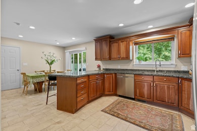
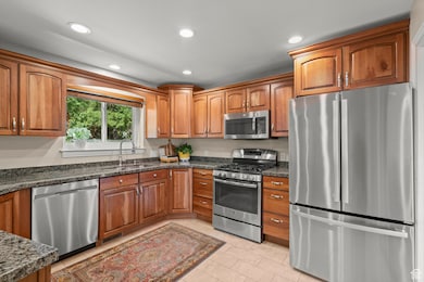
- Granite Countertops
About This Home
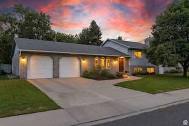
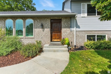
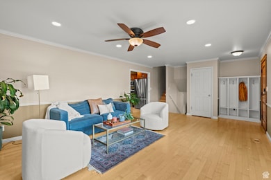
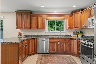
Situated in one of Provo's most sought-after Riverbottoms neighborhoods, this updated 4-bedroom, 2.5-bath home has everything you're looking for. The open, light-filled floor plan features hardwood floors, triple-pane windows, and two inviting living areas-perfect for gathering or relaxing. The kitchen offers granite countertops, updated appliances, and serene mountain views. Recent improvements include a high-efficiency furnace, heat pump, tankless water heater, water softener, and radon mitigation system. Added conveniences include gutters with leaf guards, an EV outlet in the extra-deep garage, and a large sealed crawl space for storage. The backyard is designed for both play and relaxation, with mature trees, garden boxes, fruit trees, and a built-in trampoline. Ideally located near BYU, Provo Canyon, the Provo River Trail, Sundance Resort, and top-rated schools, this home offers unmatched convenience and lifestyle. Come experience Riverbottoms living at its finest-schedule your private showing today! Square footage figures are provided as a courtesy estimate only and were obtained from county records. Buyer is advised to obtain an independent measurement.
Listing Agent
Candice Smoot
Vintage Properties Group Inc License #10840565 Listed on: 08/30/2025
Home Details
Home Type
- Single Family
Est. Annual Taxes
- $3,244
Year Built
- Built in 1990
Lot Details
- 9,583 Sq Ft Lot
- Lot Dimensions are 127.0x90.0x0.0
- Partially Fenced Property
- Landscaped
- Sprinkler System
- Mature Trees
- Pine Trees
- Property is zoned Single-Family
Parking
- 2 Car Attached Garage
Home Design
- Brick Exterior Construction
- Asphalt
Interior Spaces
- 2,094 Sq Ft Home
- 3-Story Property
- 1 Fireplace
- Triple Pane Windows
- Plantation Shutters
- Blinds
- Mountain Views
Kitchen
- Granite Countertops
- Disposal
Flooring
- Wood
- Carpet
- Tile
Bedrooms and Bathrooms
- 4 Bedrooms
Basement
- Exterior Basement Entry
- Natural lighting in basement
Outdoor Features
- Play Equipment
Schools
- Canyon Crest Elementary School
- Centennial Middle School
- Timpview High School
Utilities
- Central Heating and Cooling System
- Natural Gas Connected
Community Details
- No Home Owners Association
- Cove Wood Subdivision
Listing and Financial Details
- Assessor Parcel Number 36-169-0022
Map
Home Values in the Area
Average Home Value in this Area
Tax History
| Year | Tax Paid | Tax Assessment Tax Assessment Total Assessment is a certain percentage of the fair market value that is determined by local assessors to be the total taxable value of land and additions on the property. | Land | Improvement |
|---|---|---|---|---|
| 2025 | $382 | $358,050 | $347,200 | $303,800 |
| 2024 | $382 | $319,330 | $0 | $0 |
| 2023 | $412 | $308,990 | $0 | $0 |
| 2022 | $809 | $302,005 | $0 | $0 |
| 2021 | $2,533 | $432,300 | $271,200 | $161,100 |
| 2020 | $2,400 | $383,900 | $226,000 | $157,900 |
| 2019 | $2,261 | $376,200 | $226,000 | $150,200 |
| 2018 | $2,038 | $343,900 | $193,700 | $150,200 |
| 2017 | $1,827 | $169,400 | $0 | $0 |
| 2016 | $1,742 | $150,590 | $0 | $0 |
| 2015 | $1,679 | $146,630 | $0 | $0 |
| 2014 | $1,524 | $138,765 | $0 | $0 |
Property History
| Date | Event | Price | List to Sale | Price per Sq Ft |
|---|---|---|---|---|
| 11/28/2025 11/28/25 | Pending | -- | -- | -- |
| 11/17/2025 11/17/25 | Price Changed | $724,900 | -3.3% | $346 / Sq Ft |
| 10/06/2025 10/06/25 | Price Changed | $749,900 | -3.2% | $358 / Sq Ft |
| 08/30/2025 08/30/25 | For Sale | $774,900 | -- | $370 / Sq Ft |
Purchase History
| Date | Type | Sale Price | Title Company |
|---|---|---|---|
| Warranty Deed | -- | First American Title Insuran | |
| Interfamily Deed Transfer | -- | Union Title | |
| Warranty Deed | -- | Union Title | |
| Warranty Deed | -- | -- |
Mortgage History
| Date | Status | Loan Amount | Loan Type |
|---|---|---|---|
| Open | $225,700 | New Conventional | |
| Previous Owner | $228,423 | FHA |
Source: UtahRealEstate.com
MLS Number: 2108458
APN: 36-169-0022
Disclaimer: Certain information contained herein is derived from information provided by parties other than Homes.com. All information provided is deemed reliable, but is not guaranteed to be accurate and should be independently verified.
![]() IDX information is provided exclusively for consumers’ personal, non-commercial use, that it may not be used for any purpose other than to identify prospective properties consumers may be interested in purchasing, and that the data is deemed reliable but is not guaranteed accurate by the MLS. Licensor is only providing the MLS Content and not other sources of data provided in the Product.
IDX information is provided exclusively for consumers’ personal, non-commercial use, that it may not be used for any purpose other than to identify prospective properties consumers may be interested in purchasing, and that the data is deemed reliable but is not guaranteed accurate by the MLS. Licensor is only providing the MLS Content and not other sources of data provided in the Product.
Based on information from the Wasatch Front Regional Multiple Listing Service, Inc.. All data, including all measurements and calculations of area, is obtained from various sources and has not been, and will not be, verified by broker or the MLS. All information should be independently reviewed and verified for accuracy. Properties may or may not be listed by the office/agent presenting the information.
- 455 W 4150 St N
- 4246 N Stonecrossing
- 404 W 3700 N
- 387 S 1000 E
- 3535 N 160 St W
- 325 S 1000 E
- 478 S 950 E
- 299 E 4000 N
- 4161 N Canyon Rd Unit 2
- 3430 Brookside Dr
- 350 S 900 E
- 153 S 1000 E
- 111 Woodside Dr
- 1070 E 120 S
- 847 E 400 S
- 645 Foothill Dr
- 204 E 4635 N
- 3711 N Canyon Rd
- 1643 Mountain Oaks Dr
- 3305 N Shadowbrook Cir