
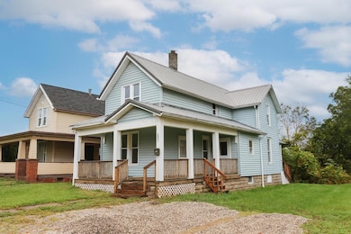


282 W 5th St Mansfield, OH 44903
Estimated payment $541/month
Highlights
- Traditional Architecture
- No HOA
- Forced Air Heating System
- Wood Flooring
About This Home
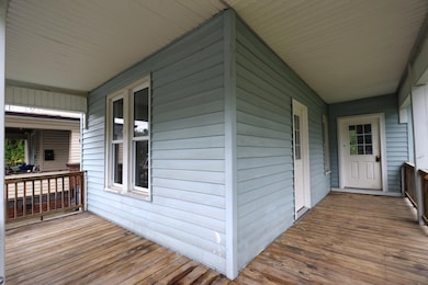
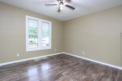
No work needed here; this updated 2-story is move-in ready! Nearly 1500 square feet, this home offers 3 bedrooms and 2 full bathrooms, including the primary bed with private ensuite. WIth a simple modification, the front living room could be converted into a 4th bedroom option. The new Metal Roof, windows and flooring in 2022, new furnace in 2024 and new carpet in 2025 make this a great buy! The laundry is located on the main floor for added convenience and the extra large lot means plenty of yard to keep the kids and pets happy too!
Home Details
Home Type
- Single Family
Est. Annual Taxes
- $502
Year Built
- Built in 1900
Lot Details
- 5,227 Sq Ft Lot
Parking
- No Garage
Home Design
- Traditional Architecture
- Vinyl Siding
Interior Spaces
- 1,480 Sq Ft Home
- 2-Story Property
- Insulated Windows
- Wood Flooring
- Basement Fills Entire Space Under The House
- Electric Range
- Laundry on main level
Bedrooms and Bathrooms
- 3 Bedrooms
Utilities
- Forced Air Heating System
- Heating System Uses Gas
- Electric Water Heater
Community Details
- No Home Owners Association
Listing and Financial Details
- Assessor Parcel Number 027-04-031-08-000
Map
Home Values in the Area
Average Home Value in this Area
Tax History
| Year | Tax Paid | Tax Assessment Tax Assessment Total Assessment is a certain percentage of the fair market value that is determined by local assessors to be the total taxable value of land and additions on the property. | Land | Improvement |
|---|---|---|---|---|
| 2024 | $527 | $10,480 | $820 | $9,660 |
| 2023 | $502 | $10,480 | $820 | $9,660 |
| 2022 | $307 | $5,380 | $950 | $4,430 |
| 2021 | $309 | $5,380 | $950 | $4,430 |
| 2020 | $317 | $5,380 | $950 | $4,430 |
| 2019 | $454 | $5,380 | $950 | $4,430 |
| 2018 | $346 | $5,380 | $950 | $4,430 |
| 2017 | $219 | $5,380 | $950 | $4,430 |
| 2016 | $101 | $1,570 | $950 | $620 |
| 2015 | $97 | $1,570 | $950 | $620 |
| 2014 | $404 | $6,640 | $950 | $5,690 |
| 2012 | $155 | $6,640 | $950 | $5,690 |
Property History
| Date | Event | Price | List to Sale | Price per Sq Ft |
|---|---|---|---|---|
| 12/11/2025 12/11/25 | Price Changed | $95,000 | -13.6% | $64 / Sq Ft |
| 10/29/2025 10/29/25 | Price Changed | $109,900 | -15.4% | $74 / Sq Ft |
| 10/07/2025 10/07/25 | For Sale | $129,900 | -- | $88 / Sq Ft |
Purchase History
| Date | Type | Sale Price | Title Company |
|---|---|---|---|
| Interfamily Deed Transfer | -- | None Available | |
| Sheriffs Deed | $4,200 | Chicago Ttl Agcy Of North Ct | |
| Warranty Deed | $8,000 | None Available | |
| Quit Claim Deed | -- | Attorney |
Source: Columbus and Central Ohio Regional MLS
MLS Number: 225038083
APN: 027-04-031-08-000
Disclaimer: Certain information contained herein is derived from information provided by parties other than Homes.com. All information provided is deemed reliable, but is not guaranteed to be accurate and should be independently verified.
![]() IDX information is provided exclusively for personal, non-commercial use, and may not be used for any purpose other than to identify prospective properties consumers may be interested in purchasing.
IDX information is provided exclusively for personal, non-commercial use, and may not be used for any purpose other than to identify prospective properties consumers may be interested in purchasing.
Information is deemed reliable but not guaranteed.
- 272 W 5th St
- 228 Clairmont Ave
- 219 W 5th St
- 362-364 W 6th St
- 169 W 5th St
- 149 W 4th St
- 212 Penn Ave
- 120 Gettings Place
- 81 Penn Ave
- 371 Bell St
- 319 Prescott St
- 0 Voegele Ave Unit Lot 6048, 6049, 6
- 30 Douglas Ave
- 237 Helen Ave
- 426 Mcpherson St
- 119 Carpenter Rd
- 118 Lind Ave
- 135 Wood St
- 480 Mcpherson St
- 131 Sturges Ave
- 50 Rowland Ave Unit 50 Rowland
- 36 W 4th St Unit 36 12
- 211 N Main St
- 153 Western Ave
- 237 Wood St
- 283 Wood St
- 300 Wood St Unit E7
- 326 Poplar St
- 227 E 2nd St
- 211 S Foster St Unit 3
- 20-60-60 S Linden Rd Unit 20-60 S Linden Rd
- 1145 Harwood Dr
- 275 Cliffbrook Dr
- 100 E Cook Rd
- 933 Ashland Rd Unit 933.5
- 478 E Cook Rd
- 733-793 Sunset Blvd
- 1386 Robinhood Ln Unit 7
- 99 Glenview
- 810 Betner Dr
