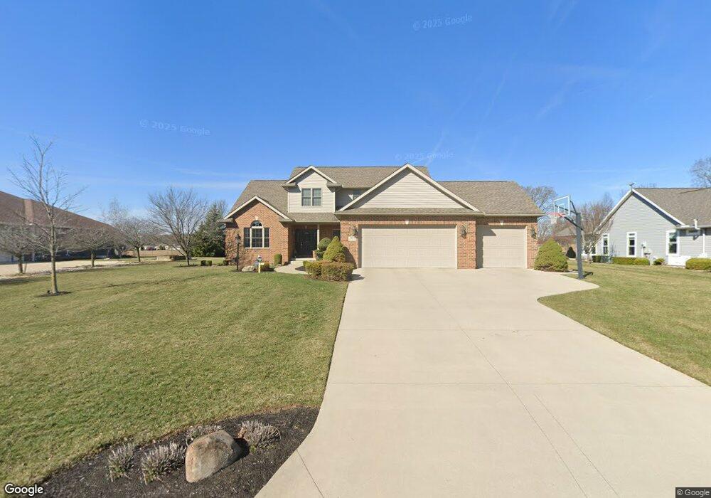
2820 Torrey Pines Dr Findlay, OH 45840
Estimated Value: $494,724 - $527,000
4
Beds
4
Baths
2,472
Sq Ft
$208/Sq Ft
Est. Value
About This Home
This home is located at 2820 Torrey Pines Dr, Findlay, OH 45840 and is currently estimated at $514,908, approximately $208 per square foot. 2820 Torrey Pines Dr is a home located in Hancock County with nearby schools including Liberty-Benton Elementary School, Liberty-Benton Middle School, and Liberty-Benton High School.
Ownership History
Date
Name
Owned For
Owner Type
Purchase Details
Closed on
Aug 30, 2013
Sold by
Cole Margaret A
Bought by
Somerville Darryl R and Somerville Leta A
Current Estimated Value
Home Financials for this Owner
Home Financials are based on the most recent Mortgage that was taken out on this home.
Original Mortgage
$292,500
Interest Rate
4.29%
Mortgage Type
New Conventional
Create a Home Valuation Report for This Property
The Home Valuation Report is an in-depth analysis detailing your home's value as well as a comparison with similar homes in the area
Home Values in the Area
Average Home Value in this Area
Purchase History
| Date | Buyer | Sale Price | Title Company |
|---|---|---|---|
| Somerville Darryl R | $325,000 | Mid American Title |
Source: Public Records
Mortgage History
| Date | Status | Borrower | Loan Amount |
|---|---|---|---|
| Closed | Somerville Darryl R | $292,500 |
Source: Public Records
Tax History Compared to Growth
Tax History
| Year | Tax Paid | Tax Assessment Tax Assessment Total Assessment is a certain percentage of the fair market value that is determined by local assessors to be the total taxable value of land and additions on the property. | Land | Improvement |
|---|---|---|---|---|
| 2024 | $5,119 | $137,720 | $24,920 | $112,800 |
| 2023 | $4,998 | $137,720 | $24,920 | $112,800 |
| 2022 | $4,950 | $137,720 | $24,920 | $112,800 |
| 2021 | $4,866 | $119,520 | $24,920 | $94,600 |
| 2020 | $4,908 | $119,520 | $24,920 | $94,600 |
| 2019 | $4,708 | $119,520 | $24,920 | $94,600 |
| 2018 | $3,903 | $109,350 | $16,610 | $92,740 |
| 2017 | $4,026 | $109,350 | $16,610 | $92,740 |
| 2016 | $3,900 | $109,350 | $16,610 | $92,740 |
| 2015 | $3,721 | $101,630 | $15,030 | $86,600 |
| 2014 | $3,712 | $100,460 | $15,030 | $85,430 |
| 2012 | $3,877 | $100,460 | $15,030 | $85,430 |
Source: Public Records
Map
Nearby Homes
- 0 County Road 95 Unit 6097574
- 6535 Silver Lake Dr
- 1405 Cypress Lake
- 3106 Saddlebrook
- 0 County Road 140
- 3018 Gleneagle Dr
- 0 Rock Candy Rd Unit Lot 159
- 0 Rock Candy Rd Unit Lot 170
- 0 Rock Candy Rd Unit Lot 172 206819
- 0 Rock Candy Rd Unit Lot 162
- 0 Rock Candy Rd Unit Lot 171
- 0 Rock Candy Rd Unit Lot 168
- 0 Rock Candy Rd Or Bushwillow Dr Unit Lot 173
- 933 Laurel Ln
- 0 Bushwillow Dr Or Rock Candy Rd Unit Lot 157
- 0 Bearcat Way Or Rock Candy Rd Unit Lot 167
- 1310 Muirfield Dr
- 9960 W Us Route 224
- 925 W Melrose Ave
- 905 W Melrose Ave
- 2814 Torrey Pines Dr
- 2819 Torrey Pines Dr
- 2813 Torrey Pines Dr
- 2808 Torrey Pines Dr
- 2825 Torrey Pines Dr
- 2807 Torrey Pines Dr
- 2831 Torrey Pines Dr
- 2802 Torrey Pines Dr
- 77 Torrey Pines Dr
- 81 Torrey Pines Dr
- 76 Torrey Pines Dr
- 2801 Torrey Pines Dr
- 1855 Firestone Dr
- 10254 C R 95
- 10254 County Road 95
- 1910 Firestone Dr
- 1750 Pinehurst Dr
- 1801 Firestone Dr
- 1733 Firestone Dr
- 2901 Pebble Beach Ct