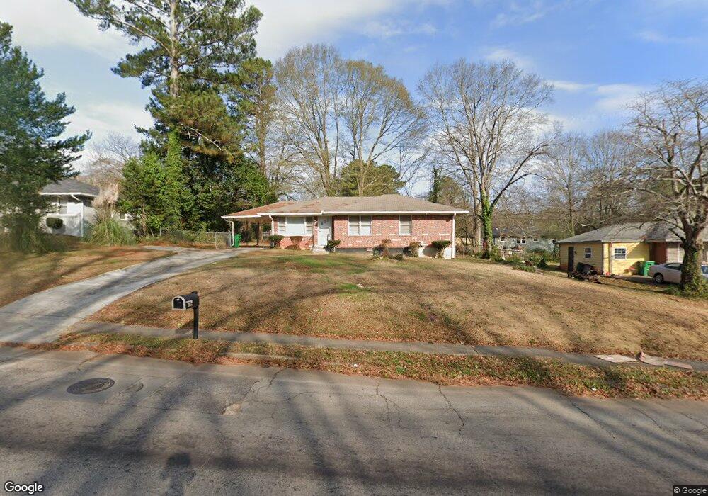
2824 Mcafee Rd Decatur, GA 30032
Estimated Value: $180,989 - $205,000
3
Beds
2
Baths
1,075
Sq Ft
$180/Sq Ft
Est. Value
About This Home
This home is located at 2824 Mcafee Rd, Decatur, GA 30032 and is currently estimated at $193,747, approximately $180 per square foot. 2824 Mcafee Rd is a home located in DeKalb County with nearby schools including Toney Elementary School, Columbia Middle School, and Columbia High School.
Ownership History
Date
Name
Owned For
Owner Type
Purchase Details
Closed on
Sep 16, 2024
Sold by
Jenkins Lydia
Bought by
Lydia Jenkins Revocable Living Trust Dat and Jenkins Lydia Tr
Current Estimated Value
Purchase Details
Closed on
Apr 23, 2013
Sold by
Thoro Finish Properties Ll
Bought by
Locke Lydia J
Purchase Details
Closed on
Jul 18, 2012
Sold by
Locke Lydia J
Bought by
Thoro Finish Properties Llc
Create a Home Valuation Report for This Property
The Home Valuation Report is an in-depth analysis detailing your home's value as well as a comparison with similar homes in the area
Home Values in the Area
Average Home Value in this Area
Purchase History
| Date | Buyer | Sale Price | Title Company |
|---|---|---|---|
| Lydia Jenkins Revocable Living Trust Dat | -- | -- | |
| Locke Lydia J | -- | -- | |
| Thoro Finish Properties Llc | -- | -- |
Source: Public Records
Tax History Compared to Growth
Tax History
| Year | Tax Paid | Tax Assessment Tax Assessment Total Assessment is a certain percentage of the fair market value that is determined by local assessors to be the total taxable value of land and additions on the property. | Land | Improvement |
|---|---|---|---|---|
| 2025 | $3,887 | $78,360 | $25,859 | $52,501 |
| 2024 | $3,883 | $78,360 | $25,859 | $52,501 |
| 2023 | $3,883 | $78,360 | $25,859 | $52,501 |
| 2022 | $2,872 | $57,480 | $10,920 | $46,560 |
| 2021 | $2,477 | $48,480 | $10,920 | $37,560 |
| 2020 | $2,250 | $43,320 | $10,920 | $32,400 |
| 2019 | $2,445 | $47,760 | $10,920 | $36,840 |
| 2018 | $1,391 | $32,680 | $10,920 | $21,760 |
| 2017 | $1,240 | $20,200 | $3,360 | $16,840 |
| 2016 | $989 | $14,480 | $3,360 | $11,120 |
| 2014 | $943 | $13,120 | $3,360 | $9,760 |
Source: Public Records
Map
Nearby Homes
- 2819 Long Way
- 2791 Mcafee Rd
- 1981 Meadow Ln
- 2812 Mitchell Dr
- 2854 Mitchell Dr
- 1996 Meadow Ln
- 2075 Dellwood Place
- 2917 Mcafee Rd
- 2922 Dale Place
- 2096 Dellwood Place
- 2728 Mcafee Rd
- 1909 Meadow Ln
- 1903 Meadow Ln
- 2952 Mcafee Rd
- 1968 Don Juan Ln
- 1979 Creekside Ct
- 1883 Meadow Ln
- 2115 Nichols Ln
- 2753 Wedgewood Terrace
- 1884 Meadow Ln
- 2818 Mcafee Rd
- 2832 Mcafee Rd
- 2825 Mitchell Place
- 2833 Mitchell Place
- 2817 Mitchell Place
- 2810 Mcafee Rd
- 2838 Mcafee Rd
- 2829 Mcafee Rd
- 2823 Mcafee Rd
- 2815 Mcafee Rd
- 2809 Mitchell Place
- 2839 Mitchell Place
- 2011 Holly Hill Dr
- 0 Mitchell Place Unit 3282692
- 0 Mitchell Place Unit 3165740
- 0 Mitchell Place Unit 8306733
- 0 Mitchell Place Unit 8849010
- 0 Mitchell Place Unit 8488106
- 2805 Mitchell Place
- 2848 Mcafee Rd