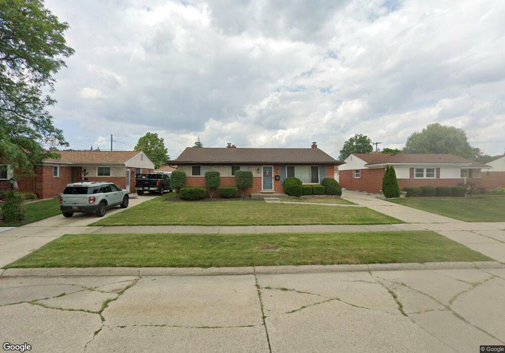
28254 Merritt Dr Westland, MI 48185
Estimated Value: $246,000 - $268,000
--
Bed
3
Baths
1,107
Sq Ft
$231/Sq Ft
Est. Value
About This Home
This home is located at 28254 Merritt Dr, Westland, MI 48185 and is currently estimated at $256,150, approximately $231 per square foot. 28254 Merritt Dr is a home located in Wayne County with nearby schools including Cleveland Elementary School, Cooper Upper Elementary School, and Emerson Middle School.
Ownership History
Date
Name
Owned For
Owner Type
Purchase Details
Closed on
Nov 23, 2021
Sold by
Nichols Rebecca J and Nichols Rebecca
Bought by
Nichols Rebecca and Shelton Brent
Current Estimated Value
Home Financials for this Owner
Home Financials are based on the most recent Mortgage that was taken out on this home.
Original Mortgage
$90,600
Outstanding Balance
$70,365
Interest Rate
2.33%
Mortgage Type
New Conventional
Estimated Equity
$185,785
Purchase Details
Closed on
Dec 21, 2011
Sold by
Nichols John M
Bought by
Nichols Rebecca
Purchase Details
Closed on
Oct 20, 2006
Sold by
Fremder Matthew P and Fremder Angela L
Bought by
Nichols John M
Purchase Details
Closed on
Sep 23, 1997
Sold by
Gonza Laura J and Gonza Thomas P
Bought by
Fremder Angela L and Fremder Matthew P
Create a Home Valuation Report for This Property
The Home Valuation Report is an in-depth analysis detailing your home's value as well as a comparison with similar homes in the area
Home Values in the Area
Average Home Value in this Area
Purchase History
| Date | Buyer | Sale Price | Title Company |
|---|---|---|---|
| Nichols Rebecca | -- | None Available | |
| Nichols Rebecca | -- | None Available | |
| Nichols John M | $155,000 | Multiple | |
| Fremder Angela L | $123,500 | -- |
Source: Public Records
Mortgage History
| Date | Status | Borrower | Loan Amount |
|---|---|---|---|
| Open | Nichols Rebecca | $90,600 |
Source: Public Records
Tax History Compared to Growth
Tax History
| Year | Tax Paid | Tax Assessment Tax Assessment Total Assessment is a certain percentage of the fair market value that is determined by local assessors to be the total taxable value of land and additions on the property. | Land | Improvement |
|---|---|---|---|---|
| 2025 | $2,318 | $105,300 | $0 | $0 |
| 2024 | $2,318 | $98,000 | $0 | $0 |
| 2023 | $2,214 | $88,800 | $0 | $0 |
| 2022 | $2,562 | $80,100 | $0 | $0 |
| 2021 | $2,497 | $76,200 | $0 | $0 |
| 2020 | $2,471 | $72,300 | $0 | $0 |
| 2019 | $2,355 | $71,500 | $0 | $0 |
| 2018 | $1,869 | $65,500 | $0 | $0 |
| 2017 | $827 | $63,800 | $0 | $0 |
| 2016 | $2,245 | $59,600 | $0 | $0 |
| 2015 | $4,549 | $53,050 | $0 | $0 |
| 2013 | $4,407 | $45,060 | $0 | $0 |
| 2012 | $2,046 | $46,390 | $0 | $0 |
Source: Public Records
Map
Nearby Homes
- 27753 Trailbrooke Cir
- 8565 Cardwell St
- 8916 Deering St
- 8537 Mercedes St
- 29000 Joy Rd
- 29102 Manchester St
- 8139 Bristol St Unit 170
- 29047 Manchester St Unit 83
- 29156 Manchester St
- 29248 Manchester St
- 7641 N Inkster Rd
- 29256 Brody Ave
- 27047 Clairview Dr
- 9137 San Jose
- 27023 Clairview Dr
- 26790 Joy Rd Unit 7
- 0000 N Middlebelt Rd
- 7401 Floral St
- 9066 Newport Way Unit 11
- 9065 Newport Way Unit 19
- 28242 Merritt Dr
- 28266 Merritt Dr
- 28230 Merritt Dr
- 28278 Merritt Dr
- 28151 Mackenzie Dr
- 28139 Mackenzie Dr
- 28209 Mackenzie Dr
- 28125 Mackenzie Dr
- 28221 Mackenzie Dr
- 28218 Merritt Dr
- 28290 Merritt Dr
- 28253 Merritt Dr
- 28241 Merritt Dr
- 28265 Merritt Dr
- 28117 Mackenzie Dr
- 28277 Merritt Dr
- 28233 Mackenzie Dr
- 28229 Merritt Dr
- 8466 Gilman St
- V/L Gilman