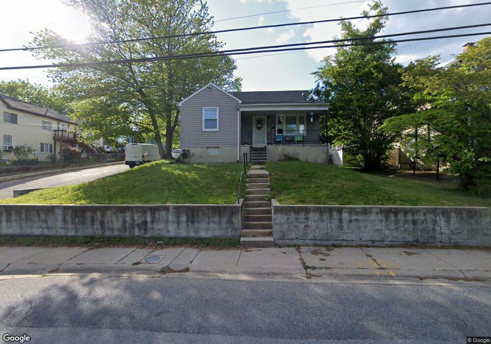
2826 Georgetown Rd Baltimore, MD 21230
Morrell Park NeighborhoodEstimated Value: $203,000 - $212,815
Studio
2
Baths
1,404
Sq Ft
$148/Sq Ft
Est. Value
About This Home
This home is located at 2826 Georgetown Rd, Baltimore, MD 21230 and is currently estimated at $207,908, approximately $148 per square foot. 2826 Georgetown Rd is a home located in Baltimore City with nearby schools including Morrell Park Elementary/Middle School, Booker T. Washington Middle School, and Digital Harbor High School.
Ownership History
Date
Name
Owned For
Owner Type
Purchase Details
Closed on
Sep 6, 2005
Sold by
Edmonds Brenda A
Bought by
Whittington Charles Dennis
Current Estimated Value
Purchase Details
Closed on
Dec 1, 2004
Sold by
Wall Emily S
Bought by
Edmonds Brenda A and Struk Edward R
Purchase Details
Closed on
Aug 30, 2004
Sold by
Wall Emily S
Bought by
Edmonds Brenda A and Struk Edward R
Purchase Details
Closed on
Oct 4, 2001
Sold by
Rita K Westinghouse
Bought by
Wall Emily S
Create a Home Valuation Report for This Property
The Home Valuation Report is an in-depth analysis detailing your home's value as well as a comparison with similar homes in the area
Home Values in the Area
Average Home Value in this Area
Purchase History
| Date | Buyer | Sale Price | Title Company |
|---|---|---|---|
| Whittington Charles Dennis | $130,950 | -- | |
| Edmonds Brenda A | $125,000 | -- | |
| Edmonds Brenda A | $125,000 | -- | |
| Wall Emily S | $75,500 | -- |
Source: Public Records
Tax History
| Year | Tax Paid | Tax Assessment Tax Assessment Total Assessment is a certain percentage of the fair market value that is determined by local assessors to be the total taxable value of land and additions on the property. | Land | Improvement |
|---|---|---|---|---|
| 2025 | $3,690 | $170,600 | -- | -- |
| 2024 | $3,690 | $157,100 | -- | -- |
| 2023 | $3,373 | $143,600 | $42,600 | $101,000 |
| 2022 | $3,389 | $143,600 | $42,600 | $101,000 |
| 2021 | $3,389 | $143,600 | $42,600 | $101,000 |
| 2020 | $3,391 | $143,700 | $42,600 | $101,100 |
| 2019 | $3,375 | $143,700 | $42,600 | $101,100 |
| 2018 | $3,391 | $143,700 | $42,600 | $101,100 |
| 2017 | $3,717 | $157,500 | $0 | $0 |
| 2016 | $3,017 | $147,333 | $0 | $0 |
| 2015 | $3,017 | $137,167 | $0 | $0 |
| 2014 | $3,017 | $127,000 | $0 | $0 |
Source: Public Records
Map
Nearby Homes
- 1707 Morrell Park Ave
- 1710 Wickes Ave
- 1803 Casadel Ave
- 1613 S Ellamont St
- 2809 Washington Blvd
- 1920 Maudlin Ave
- 1918 Parksley Ave
- 1704 Harman Ave
- 2506 Washington Blvd
- 1707 Harman Ave
- 2036 Deering Ave
- 1706 Sexton St
- 2453 Washington Blvd
- 1909 Harman Ave
- 1703 - 1707 1/2 Spence St
- 2104 Whistler Ave
- 1637 Spence St
- 1933 Grinnalds Ave
- 1935 Grinnalds Ave
- 1701 Spence St
- 2824 Georgetown Rd
- 2830 Georgetown Rd
- 2821 Georgetown Rd
- 2812 Georgetown Rd
- 2823 Georgetown Rd
- 1410 Saint Marks Ave
- 2817 Ottawa Ave
- 2817 Georgetown Rd
- 2840 Georgetown Rd
- 1405 Saint Marks Ave
- 2825 Georgetown Rd
- 2815 Georgetown Rd
- 2808 Georgetown Rd
- 2813 Georgetown Rd
- 1404 Saint Marks Ave
- 2827 Georgetown Rd
- 2844 Georgetown Rd
- 1409 Forest Hill Ave
- 1400 Gloster Ave
- 1401 Saint Marks Ave
Your Personal Tour Guide
Ask me questions while you tour the home.