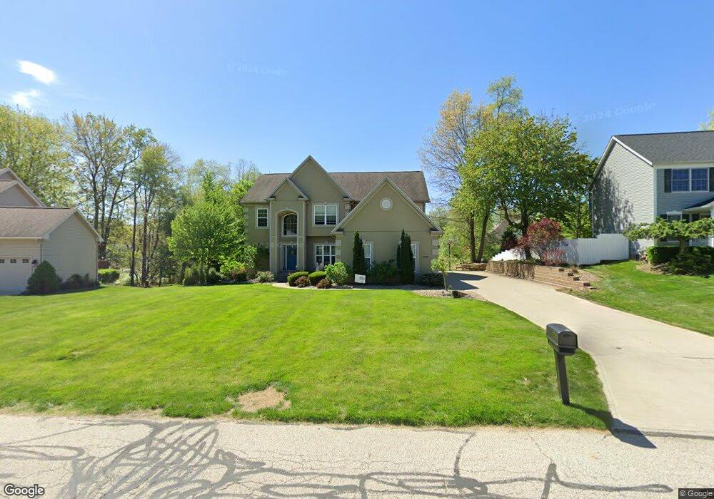
2828 Crows Nest Cir Uniontown, OH 44685
Estimated Value: $414,000 - $495,000
4
Beds
3
Baths
2,545
Sq Ft
$172/Sq Ft
Est. Value
About This Home
This home is located at 2828 Crows Nest Cir, Uniontown, OH 44685 and is currently estimated at $437,492, approximately $171 per square foot. 2828 Crows Nest Cir is a home located in Summit County with nearby schools including Greenwood Elementary School, Green Primary School, and Green Intermediate Elementary School.
Ownership History
Date
Name
Owned For
Owner Type
Purchase Details
Closed on
May 25, 2007
Sold by
Caporaletti Jeffrey and Caporaletti Lisa R
Bought by
Caporaletti Jeffrey and Caporaletti Lisa R
Current Estimated Value
Purchase Details
Closed on
Sep 11, 2006
Sold by
Union Commerce Corp
Bought by
Caporaletti Jeffrey and Caporaletti Anthony
Create a Home Valuation Report for This Property
The Home Valuation Report is an in-depth analysis detailing your home's value as well as a comparison with similar homes in the area
Home Values in the Area
Average Home Value in this Area
Purchase History
| Date | Buyer | Sale Price | Title Company |
|---|---|---|---|
| Caporaletti Jeffrey | $18,930 | Attorney | |
| Caporaletti Jeffrey | $51,000 | Land America-Lawyers Title |
Source: Public Records
Tax History Compared to Growth
Tax History
| Year | Tax Paid | Tax Assessment Tax Assessment Total Assessment is a certain percentage of the fair market value that is determined by local assessors to be the total taxable value of land and additions on the property. | Land | Improvement |
|---|---|---|---|---|
| 2025 | $5,715 | $120,800 | $20,815 | $99,985 |
| 2024 | $5,715 | $120,800 | $20,815 | $99,985 |
| 2023 | $5,715 | $120,800 | $20,815 | $99,985 |
| 2022 | $5,133 | $97,419 | $16,786 | $80,633 |
| 2021 | $4,814 | $97,419 | $16,786 | $80,633 |
| 2020 | $4,722 | $97,420 | $16,790 | $80,630 |
| 2019 | $4,388 | $84,760 | $16,110 | $68,650 |
| 2018 | $4,485 | $84,760 | $16,110 | $68,650 |
| 2017 | $4,154 | $84,760 | $16,110 | $68,650 |
| 2016 | $4,134 | $73,630 | $16,110 | $57,520 |
| 2015 | $4,154 | $73,630 | $16,110 | $57,520 |
| 2014 | $4,127 | $73,630 | $16,110 | $57,520 |
| 2013 | $4,218 | $74,840 | $16,110 | $58,730 |
Source: Public Records
Map
Nearby Homes
- 3217 Deborah Ct
- 3212 Deborah Ct
- 3979 Northdale St NW
- 2771 Superior Dr
- 2944 Sunset Dr
- 0 Pine St NW
- Northwood Plan at Spring Hill - Spring Hill Villas
- Kenai Plan at Spring Hill - Spring Hill Villas
- Bradbern Plan at Spring Hill - Spring Hill Villas
- Sarasota Plan at Spring Hill - Spring Hill Villas
- Holston Plan at Spring Hill - Spring Hill Villas
- Chester Plan at Spring Hill - Spring Hill Villas
- 2500 Marlborough Dr
- 2418 Island Dr
- 13704 Greenland Ave NW
- 3534 Chanticleer Ct
- 3514 Chanticleer Ct
- 3796 Sweitzer St NW
- 2511 Royal County Down
- 2518 Glenshire Cir Unit 36A
- 2820 Crows Nest Cir
- 2836 Crows Nest Cir
- 2829 Crows Nest Cir
- 2815 Alexandria Ct
- 2807 Alexandria Ct
- 2812 Crows Nest Cir
- 3000 Matthew Ct
- 2837 Crows Nest Cir
- 2799 Alexandria Ct
- 2821 Crows Nest Cir
- 2827 Alexandria Ct
- S/L 161 Matthew Ct
- 2804 Crows Nest Cir
- 2791 Alexandria Ct
- 2853 Crows Nest Cir
- 3008 Matthew Ct
- 2806 Alexandria Ct
- 2805 Crows Nest Cir
- 2798 Alexandria Ct
- 3081 Bear Hollow Rd