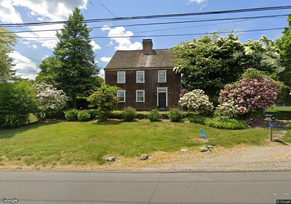
2829 Bronson Rd Fairfield, CT 06824
Greenfield Hill NeighborhoodEstimated Value: $2,014,308 - $2,829,000
4
Beds
5
Baths
4,220
Sq Ft
$588/Sq Ft
Est. Value
About This Home
This home is located at 2829 Bronson Rd, Fairfield, CT 06824 and is currently estimated at $2,480,827, approximately $587 per square foot. 2829 Bronson Rd is a home located in Fairfield County with nearby schools including Dwight Elementary School, Roger Ludlowe Middle School, and Fairfield Ludlowe High School.
Ownership History
Date
Name
Owned For
Owner Type
Purchase Details
Closed on
Jul 6, 2020
Sold by
Arthur Gravanis Ret
Bought by
Arthur Gravanis T
Current Estimated Value
Purchase Details
Closed on
Jun 4, 2019
Sold by
Gravanis Arthur
Bought by
Arthur Gravanis Ret
Purchase Details
Closed on
Jun 28, 2005
Sold by
Oburchay Christopher C
Bought by
Gravanis Arthur
Purchase Details
Closed on
May 14, 2002
Sold by
Carano Maria A and Carano Boyd
Bought by
Oburchag Jeanine M and Oburchag Christopher C
Purchase Details
Closed on
Sep 24, 1998
Sold by
Snyder Peter V and Snyder Mary H
Bought by
Carano Boyd and Carano Maria A
Create a Home Valuation Report for This Property
The Home Valuation Report is an in-depth analysis detailing your home's value as well as a comparison with similar homes in the area
Home Values in the Area
Average Home Value in this Area
Purchase History
| Date | Buyer | Sale Price | Title Company |
|---|---|---|---|
| Arthur Gravanis T | -- | None Available | |
| Arthur Gravanis T | -- | None Available | |
| Arthur Gravanis Ret | -- | -- | |
| Arthur Gravanis Ret | -- | -- | |
| Gravanis Arthur | $1,625,000 | -- | |
| Gravanis Arthur | $1,625,000 | -- | |
| Oburchag Jeanine M | $1,175,000 | -- | |
| Oburchag Jeanine M | $1,175,000 | -- | |
| Carano Boyd | $1,065,000 | -- | |
| Carano Boyd | $1,065,000 | -- |
Source: Public Records
Mortgage History
| Date | Status | Borrower | Loan Amount |
|---|---|---|---|
| Previous Owner | Carano Boyd | $250,000 | |
| Previous Owner | Carano Boyd | $775,000 |
Source: Public Records
Tax History
| Year | Tax Paid | Tax Assessment Tax Assessment Total Assessment is a certain percentage of the fair market value that is determined by local assessors to be the total taxable value of land and additions on the property. | Land | Improvement |
|---|---|---|---|---|
| 2025 | $21,582 | $760,200 | $267,470 | $492,730 |
| 2024 | $21,210 | $760,200 | $267,470 | $492,730 |
| 2023 | $20,913 | $760,200 | $267,470 | $492,730 |
| 2022 | $20,708 | $760,200 | $267,470 | $492,730 |
| 2021 | $20,510 | $760,200 | $267,470 | $492,730 |
| 2020 | $26,329 | $982,800 | $324,310 | $658,490 |
| 2019 | $26,329 | $982,800 | $324,310 | $658,490 |
| 2018 | $25,907 | $982,800 | $324,310 | $658,490 |
| 2017 | $24,823 | $961,380 | $324,310 | $637,070 |
| 2016 | $24,467 | $961,380 | $324,310 | $637,070 |
| 2015 | $24,515 | $988,890 | $367,780 | $621,110 |
| 2014 | $24,129 | $988,890 | $367,780 | $621,110 |
Source: Public Records
Map
Nearby Homes
- 2683 Bronson Rd
- 1380 Old Academy Rd
- 110 Queens Grant Dr
- 688 Hulls Farm Rd
- 360 Duck Farm Rd
- 3674 Congress St
- 148 Millspaugh Dr
- 218 Lower Farm Rd
- 1 Sturges Hwy Unit 2
- 2177 Cross Hwy
- 1353 Mill Plain Rd
- 1115 Galloping Hill Rd
- 21 Sturges Commons
- 10 Debra Ln
- 54 Ridgedale Rd
- 1091 Round Hill Rd
- 6 Buckboard Ln
- 647 Bronson Rd
- 281 Wood House Rd
- 210 Pansy Rd
- 2824 Bronson Rd
- 2793 Bronson Rd
- 703 Verna Hill Rd
- 2860 Bronson Rd
- 2905 Bronson Rd
- 2759 Bronson Rd
- 2761 Bronson Rd
- 745 Verna Hill Rd
- 2739 Bronson Rd
- 710 Verna Hill Rd
- 2943 Bronson Rd
- 2713 Bronson Rd
- 2550 Bronson Rd
- 539 Verna Hill Rd
- 799 Verna Hill Rd
- 537 Verna Hill Rd
- 750 Verna Hill Rd
- 800 Verna Hill Rd
- 821 Verna Hill Rd
- 840 Verna Hill Rd
Your Personal Tour Guide
Ask me questions while you tour the home.