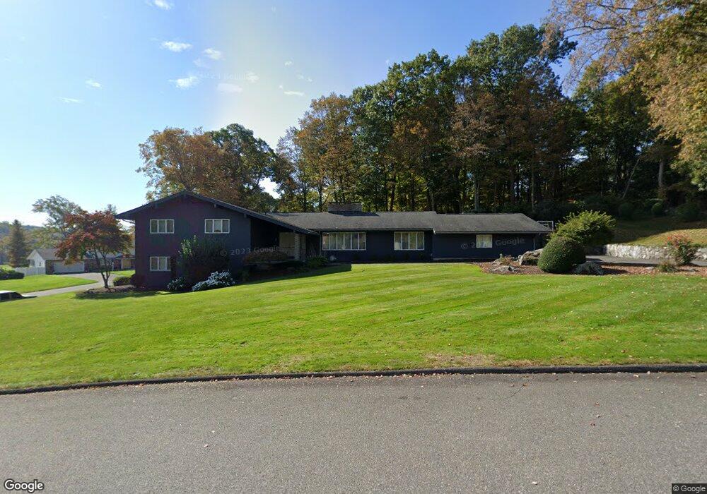
283 Maybrook Rd Waterbury, CT 06708
West End District NeighborhoodEstimated Value: $594,988 - $780,000
3
Beds
4
Baths
2,924
Sq Ft
$228/Sq Ft
Est. Value
About This Home
This home is located at 283 Maybrook Rd, Waterbury, CT 06708 and is currently estimated at $667,747, approximately $228 per square foot. 283 Maybrook Rd is a home located in New Haven County with nearby schools including B.W. Tinker School, West Side Middle School, and John F. Kennedy High School.
Ownership History
Date
Name
Owned For
Owner Type
Purchase Details
Closed on
Feb 23, 2021
Sold by
Orourke Diana M and Nardozzi James F
Bought by
Orourke Diana M and Nardozzi James F
Current Estimated Value
Home Financials for this Owner
Home Financials are based on the most recent Mortgage that was taken out on this home.
Original Mortgage
$266,000
Outstanding Balance
$152,942
Interest Rate
2.7%
Mortgage Type
Balloon
Estimated Equity
$514,805
Purchase Details
Closed on
Apr 9, 2001
Sold by
Distasio Alfred J and Distasio Flora J
Bought by
Nardozzi James F and Nardozzi Theresa M
Create a Home Valuation Report for This Property
The Home Valuation Report is an in-depth analysis detailing your home's value as well as a comparison with similar homes in the area
Home Values in the Area
Average Home Value in this Area
Purchase History
| Date | Buyer | Sale Price | Title Company |
|---|---|---|---|
| Orourke Diana M | -- | None Available | |
| Nardozzi James F | $300,000 | -- |
Source: Public Records
Mortgage History
| Date | Status | Borrower | Loan Amount |
|---|---|---|---|
| Open | Orourke Diana M | $266,000 | |
| Previous Owner | Nardozzi James F | $35,000 | |
| Previous Owner | Nardozzi James F | $167,500 | |
| Previous Owner | Nardozzi James F | $200,000 |
Source: Public Records
Tax History Compared to Growth
Tax History
| Year | Tax Paid | Tax Assessment Tax Assessment Total Assessment is a certain percentage of the fair market value that is determined by local assessors to be the total taxable value of land and additions on the property. | Land | Improvement |
|---|---|---|---|---|
| 2025 | $15,913 | $353,780 | $63,000 | $290,780 |
| 2024 | $17,491 | $353,780 | $63,000 | $290,780 |
| 2023 | $19,171 | $353,780 | $63,000 | $290,780 |
| 2022 | $13,420 | $222,890 | $62,940 | $159,950 |
| 2021 | $13,420 | $222,890 | $62,940 | $159,950 |
| 2020 | $13,420 | $222,890 | $62,940 | $159,950 |
| 2019 | $13,420 | $222,890 | $62,940 | $159,950 |
| 2018 | $13,420 | $222,890 | $62,940 | $159,950 |
| 2017 | $13,846 | $229,960 | $62,940 | $167,020 |
| 2016 | $13,846 | $229,960 | $62,940 | $167,020 |
| 2015 | $13,388 | $229,960 | $62,940 | $167,020 |
| 2014 | $13,388 | $229,960 | $62,940 | $167,020 |
Source: Public Records
Map
Nearby Homes
- 1 Umberfield Rd
- 104 Eastfield Rd
- 77 Eastfield Rd
- 55 Eastfield Rd
- 141 Joshua Town Rd
- 116 Joshua Town Rd
- 49 Southridge Dr
- 197 Hickory Hill Dr
- 62 Cheryl Dr
- 0 Mason Ave
- 120 Mason Ave
- 37 Mason Ave
- 110 Wooster Ave
- 94 Wooster Ave
- 352 Highland Dr
- 36 Ernest Ave
- 67 Barrington Ln
- 354 Bradley Ave
- 26 Oakleaf Dr
- 1 Ruth Parsons Dr
- 292 Maybrook Rd
- 19 Shiring Ln
- 251 Maybrook Rd
- 319 Maybrook Rd
- 50 Shiring Ln
- 47 Shiring Ln
- 227 Maybrook Rd
- 232 Maybrook Rd
- 11 Southgate Rd
- 340 Maybrook Rd
- 37 Southgate Rd
- 359 Maybrook Rd
- 14 Southgate Rd
- 205 Maybrook Rd
- 22 Southgate Rd
- 86 Middleway E
- 34 Southgate Rd
- 80 Middleway E
- 73 Medway Rd
- 365 Maybrook Rd