Estimated Value: $860,000 - $907,973
5
Beds
4
Baths
4,510
Sq Ft
$197/Sq Ft
Est. Value
About This Home
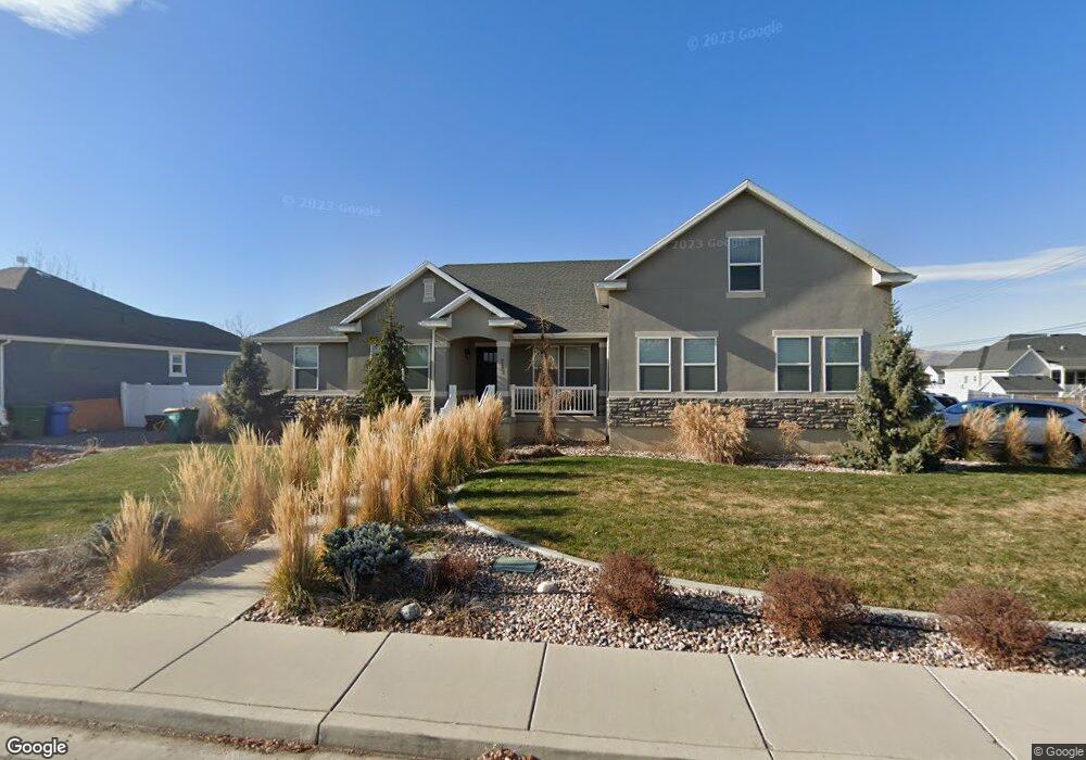
This home is located at 283 N 1700 W Unit 128, Lehi, UT 84043 and is currently estimated at $888,993, approximately $197 per square foot. 283 N 1700 W Unit 128 is a home located in Utah County with nearby schools including River Rock Elementary, Willowcreek Middle School, and Lehi High School.
Ownership History
Date
Name
Owned For
Owner Type
Purchase Details
Closed on
Nov 17, 2023
Sold by
Bradshaw Eric
Bought by
Bradshaw Eric and Bradshaw Rebecca
Current Estimated Value
Home Financials for this Owner
Home Financials are based on the most recent Mortgage that was taken out on this home.
Original Mortgage
$233,300
Outstanding Balance
$229,284
Interest Rate
7.57%
Mortgage Type
New Conventional
Estimated Equity
$659,709
Purchase Details
Closed on
Aug 13, 2013
Sold by
Bd Homes Lehi Llc
Bought by
Bradshaw Eric
Home Financials for this Owner
Home Financials are based on the most recent Mortgage that was taken out on this home.
Original Mortgage
$288,909
Interest Rate
3.37%
Mortgage Type
Adjustable Rate Mortgage/ARM
Purchase Details
Closed on
May 31, 2011
Sold by
Larson Farm Lc
Bought by
Bd Homes Lehi Llc
Create a Home Valuation Report for This Property
The Home Valuation Report is an in-depth analysis detailing your home's value as well as a comparison with similar homes in the area
Home Values in the Area
Average Home Value in this Area
Purchase History
| Date | Buyer | Sale Price | Title Company |
|---|---|---|---|
| Bradshaw Eric | -- | Radian Settlement Services | |
| Bradshaw Eric | -- | Affiliated First Title Compa | |
| Bd Homes Lehi Llc | -- | Integrated Title Insurance S |
Source: Public Records
Mortgage History
| Date | Status | Borrower | Loan Amount |
|---|---|---|---|
| Open | Bradshaw Eric | $233,300 | |
| Previous Owner | Bradshaw Eric | $288,909 |
Source: Public Records
Tax History Compared to Growth
Tax History
| Year | Tax Paid | Tax Assessment Tax Assessment Total Assessment is a certain percentage of the fair market value that is determined by local assessors to be the total taxable value of land and additions on the property. | Land | Improvement |
|---|---|---|---|---|
| 2025 | $3,507 | $443,190 | $334,100 | $471,700 |
| 2024 | $3,507 | $410,465 | $0 | $0 |
| 2023 | $3,269 | $415,360 | $0 | $0 |
| 2022 | $3,544 | $436,590 | $0 | $0 |
| 2021 | $3,158 | $588,200 | $193,300 | $394,900 |
| 2020 | $2,977 | $548,100 | $179,000 | $369,100 |
| 2019 | $2,675 | $511,900 | $179,000 | $332,900 |
| 2018 | $2,484 | $449,400 | $153,400 | $296,000 |
| 2017 | $2,459 | $236,500 | $0 | $0 |
| 2016 | $2,552 | $227,700 | $0 | $0 |
| 2015 | $2,350 | $199,100 | $0 | $0 |
| 2014 | $2,291 | $192,940 | $0 | $0 |
Source: Public Records
Map
Nearby Homes
- 131 S 1900 W Unit 2
- 2162 W Main St Unit E303
- 161 S 1475 W
- 2178 W Main St Unit D301
- 41 N 2150 W
- 1784 W Grays Place
- 202 S 2035 W
- 1743 W Grays Place
- 1215 W 125 S
- 380 S 1500 W
- 1356 W 425 S
- 374 S 1330 West St
- 1379 W 425 S
- 1363 W 425 S
- The Annie Plan at Longhorn Meadows
- The Kaitlyn Plan at Longhorn Meadows
- The Autumn Plan at Longhorn Meadows
- The Aurora Plan at Longhorn Meadows
- The Roosevelt Plan at Longhorn Meadows
- The Christine Plan at Longhorn Meadows
- 251 N 1700 W Unit 129
- 9600 W 8800 N
- 9656 W 8800 N
- 313 N 1700 W
- 217 N 1700 W
- 8766 N 9150 W
- 322 N 1750 W
- 254 N Constitution Dr Unit 126
- 278 N Constitution Dr Unit 127
- 318 N 1700 W Unit 19
- 318 N 1700 W
- 212 N Constitution Dr
- 321 N 1750 W
- 8730 N 9150 W
- 1719 W Dawn St
- 1719 W Dawn St Unit 124
- 1751 W Dawn St Unit 123
- 333 N 1750 W
- 333 N 1600 W
- 334 N 1700 W Unit 18