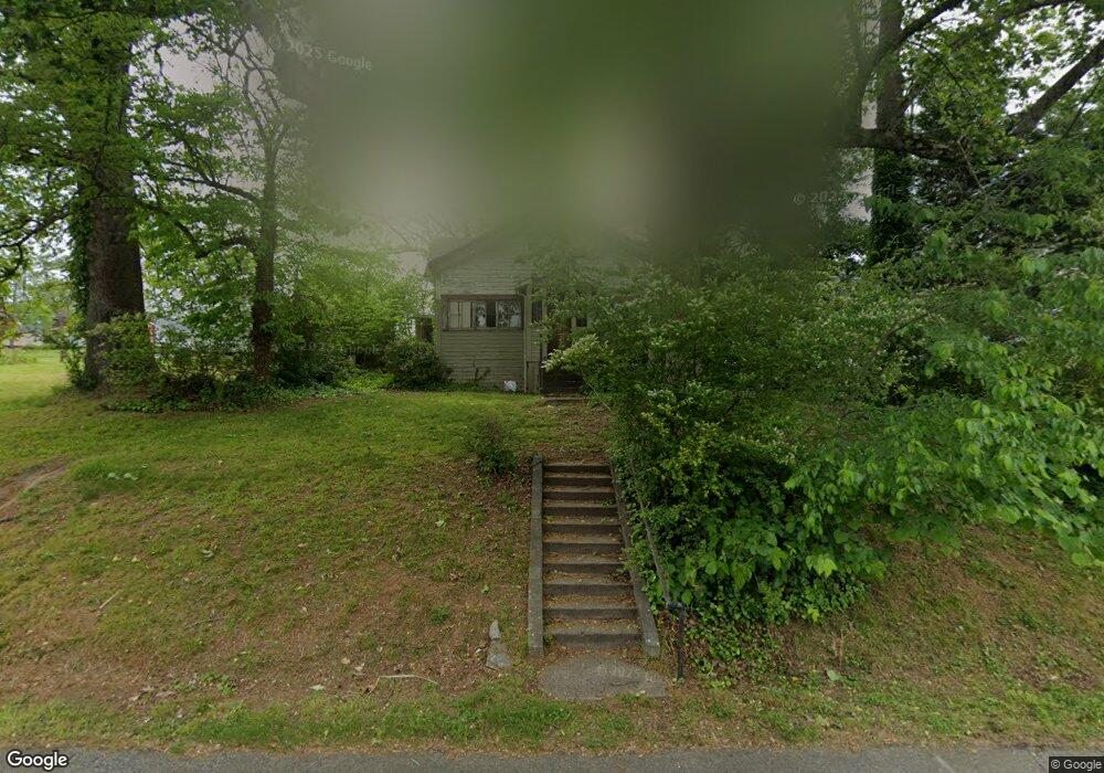
283 N Laurel Ave Demorest, GA 30535
Estimated Value: $123,624 - $281,000
2
Beds
1
Bath
1,148
Sq Ft
$193/Sq Ft
Est. Value
About This Home
This home is located at 283 N Laurel Ave, Demorest, GA 30535 and is currently estimated at $221,541, approximately $192 per square foot. 283 N Laurel Ave is a home with nearby schools including Demorest Elementary School, Wilbanks Middle School, and Habersham Success Academy.
Ownership History
Date
Name
Owned For
Owner Type
Purchase Details
Closed on
Feb 1, 2022
Sold by
Holbrooks Fred C
Bought by
Fcholbrooks Family Holdings Llc
Current Estimated Value
Purchase Details
Closed on
Dec 17, 2020
Sold by
Holbrooks Fred C
Bought by
Fcholbrooks Family Holdings Llc
Purchase Details
Closed on
Mar 12, 2010
Sold by
London Joyce West
Bought by
Holbrooks Fred
Purchase Details
Closed on
May 8, 2009
Sold by
London Joyce West
Bought by
London Joyce West
Create a Home Valuation Report for This Property
The Home Valuation Report is an in-depth analysis detailing your home's value as well as a comparison with similar homes in the area
Home Values in the Area
Average Home Value in this Area
Purchase History
| Date | Buyer | Sale Price | Title Company |
|---|---|---|---|
| Fcholbrooks Family Holdings Llc | -- | -- | |
| Hemmer Jason K | $25,000 | -- | |
| Fcholbrooks Family Holdings Llc | -- | -- | |
| Holbrooks Fred | $20,000 | -- | |
| London Joyce West | -- | -- |
Source: Public Records
Tax History Compared to Growth
Tax History
| Year | Tax Paid | Tax Assessment Tax Assessment Total Assessment is a certain percentage of the fair market value that is determined by local assessors to be the total taxable value of land and additions on the property. | Land | Improvement |
|---|---|---|---|---|
| 2025 | $870 | $27,776 | $7,000 | $20,776 |
| 2024 | $480 | $18,480 | $5,000 | $13,480 |
| 2023 | $250 | $10,000 | $3,100 | $6,900 |
| 2022 | $346 | $13,288 | $4,000 | $9,288 |
| 2021 | $307 | $11,820 | $3,600 | $8,220 |
| 2020 | $268 | $9,964 | $3,000 | $6,964 |
| 2019 | $268 | $9,964 | $3,000 | $6,964 |
| 2018 | $253 | $9,464 | $2,500 | $6,964 |
| 2017 | $217 | $8,092 | $2,000 | $6,092 |
| 2016 | $211 | $20,230 | $2,000 | $6,092 |
| 2015 | $209 | $20,230 | $2,000 | $6,092 |
| 2014 | $210 | $20,000 | $1,680 | $6,320 |
| 2013 | -- | $8,000 | $1,680 | $6,320 |
Source: Public Records
Map
Nearby Homes
- 198 Hickory Ave
- 133 Blue Ridge Ave
- 274 & 278 N Hazel Ave
- 107 Brasstown Ln
- 536 Wauka Dr
- 544 Wauka Dr
- Plan 2131 at Habersham Meadows
- Plan 1709 at Habersham Meadows
- Plan 2307 at Habersham Meadows
- Plan 1902 at Habersham Meadows
- Plan 3119 at Habersham Meadows
- Plan 2408 at Habersham Meadows
- Plan 2100 at Habersham Meadows
- Plan 2628 at Habersham Meadows
- Plan 3105 at Habersham Meadows
- Plan 2121 at Habersham Meadows
- Plan 1602-2 at Habersham Meadows
- Plan 1643 at Habersham Meadows
- 515 Wauka Dr
- 545 Wauka Dr
- 127 Florida Ave
- 325 Laurel Ave
- 325 Laurel Ave Unit 10
- 154 Florida St
- 210 Oak Ave
- 206 Oak Ave
- 248 Oak Ave
- 173 Key Largo Ave
- 211 Oak Ave
- 256 Laurel Ave
- 143 Oak Place
- 205 Oak Ave
- 276 Oak Ave
- 0 Us Hwy 441 and Alabama St Unit 8309422
- 0 Us Hwy 441 and Alabama St Unit 8309428
- 0 Us Hwy 441 and Alabama St S Unit S/Q 7508524
- 503 Chestnut Ave
- 119 Oak Place
- 350 Key Largo Ave
- 230 Laurel Ave