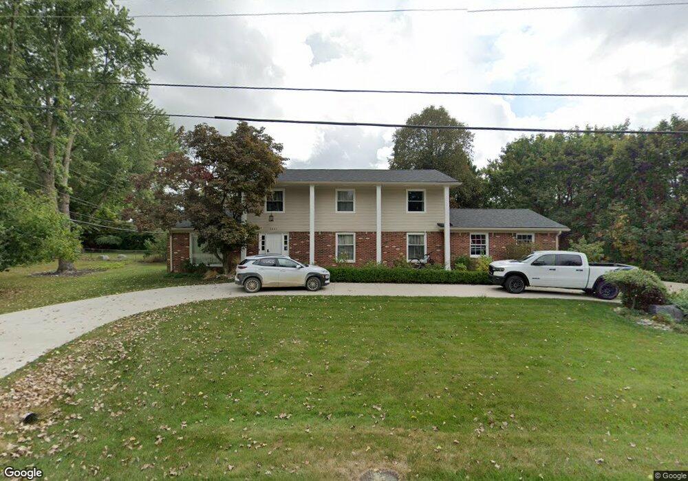
2841 Peterboro Rd West Bloomfield, MI 48323
Estimated Value: $488,570 - $638,000
4
Beds
3
Baths
2,900
Sq Ft
$194/Sq Ft
Est. Value
About This Home
This home is located at 2841 Peterboro Rd, West Bloomfield, MI 48323 and is currently estimated at $561,893, approximately $193 per square foot. 2841 Peterboro Rd is a home located in Oakland County with nearby schools including West Hills Middle School, Bloomfield Hills High School, and Brookfield Academy - West Bloomfield Campus.
Ownership History
Date
Name
Owned For
Owner Type
Purchase Details
Closed on
Aug 25, 2023
Sold by
Lutfi Samhar and Lutfi Hasnaa
Bought by
Samhar Lutfi Living Trust and Lutfi
Current Estimated Value
Purchase Details
Closed on
Oct 16, 2020
Sold by
Qalieh Bashar and Satout Yumna
Bought by
Lufti Samhar and Barakat Hasna
Purchase Details
Closed on
Apr 8, 2016
Sold by
Qalieh Bashar and Satout Yumna
Bought by
Lutfi Samhar and Barakat Hasnaa
Purchase Details
Closed on
Feb 19, 2016
Sold by
Li Rebecca M
Bought by
Qalieh Bashar and Satout Yumna
Purchase Details
Closed on
Feb 12, 2015
Sold by
Li Rebecca M and Li Chin Hsiu
Bought by
Li Rebecca M and Rebecca M Li Trust
Create a Home Valuation Report for This Property
The Home Valuation Report is an in-depth analysis detailing your home's value as well as a comparison with similar homes in the area
Home Values in the Area
Average Home Value in this Area
Purchase History
| Date | Buyer | Sale Price | Title Company |
|---|---|---|---|
| Samhar Lutfi Living Trust | -- | None Listed On Document | |
| Lufti Samhar | $341,104 | None Available | |
| Lutfi Samhar | -- | First American Title Ins Co | |
| Qalieh Bashar | $295,000 | First American Title Ins Co | |
| Li Rebecca M | -- | None Available |
Source: Public Records
Tax History Compared to Growth
Tax History
| Year | Tax Paid | Tax Assessment Tax Assessment Total Assessment is a certain percentage of the fair market value that is determined by local assessors to be the total taxable value of land and additions on the property. | Land | Improvement |
|---|---|---|---|---|
| 2024 | $3,805 | $243,870 | $0 | $0 |
| 2022 | $3,682 | $203,330 | $49,720 | $153,610 |
| 2021 | $6,627 | $206,120 | $0 | $0 |
| 2020 | $3,287 | $207,140 | $49,720 | $157,420 |
| 2018 | $6,229 | $178,720 | $33,460 | $145,260 |
| 2015 | -- | $110,040 | $0 | $0 |
| 2014 | -- | $100,400 | $0 | $0 |
| 2011 | -- | $92,120 | $0 | $0 |
Source: Public Records
Map
Nearby Homes
- 4274 Wendell Rd
- 0 Wendell Rd Unit 20250033815
- 0000 Middlebelt Rd
- 4182 Prescott Park Cir
- 4539 Middleton Ct
- 4170 Prescott Park Cir
- 3092 Woodland Ridge Dr
- 4641 Cove Rd
- 2943 Moon Lake Dr Unit 52
- 4033 Fox Lake Dr
- 3075 Bloomfield Park Dr
- 4670 Cove Rd
- 1992 Bent Tree Trail
- 4297 Wabeek Lake Dr S Unit 26
- 3367 Lone Pine Rd
- 2164 Bordeaux St
- 2045 Bordeaux St Unit 5
- 4724 Tara Ct
- 4768 Wendrick Dr
- 3352 Bloomfield Shore Dr
- 4238 Fieldbrook Rd
- 4259 Wendell Rd
- 4274 Middlebelt Rd
- 4275 Wendell Rd
- 4244 Fieldbrook Rd
- 2850 Peterboro Rd
- 4224 Fieldbrook Rd
- 4291 Wendell Rd
- 4241 Wendell Rd
- 4237 Fieldbrook Rd
- 4212 Fieldbrook Rd
- 4245 Fieldbrook Rd
- 4225 Wendell Rd
- 2915 Peterboro Rd
- 4223 Fieldbrook Rd Unit Bldg-Unit
- 4223 Fieldbrook Rd
- 4264 Fieldbrook Rd
- 4279 Middlebelt Rd
- 4290 Wendell Rd Unit Bldg-Unit
- 4290 Wendell Rd