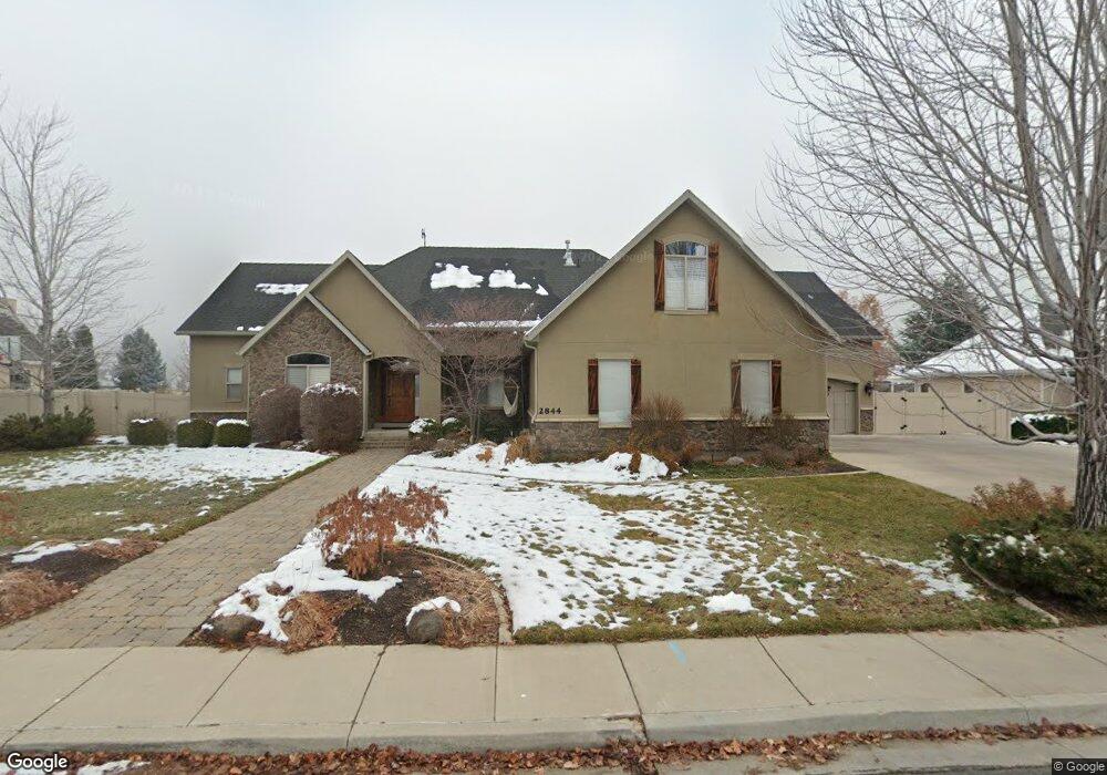
2844 N 1130 W Unit 23 Pleasant Grove, UT 84062
Estimated Value: $975,000 - $1,403,000
4
Beds
3
Baths
3,751
Sq Ft
$323/Sq Ft
Est. Value
About This Home
This home is located at 2844 N 1130 W Unit 23, Pleasant Grove, UT 84062 and is currently estimated at $1,211,836, approximately $323 per square foot. 2844 N 1130 W Unit 23 is a home located in Utah County with nearby schools including Deerfield Elementary School, Mountain Ridge Junior High School, and American Fork High School.
Ownership History
Date
Name
Owned For
Owner Type
Purchase Details
Closed on
Aug 5, 2008
Sold by
Goldston Brad
Bought by
Pinson Mark and Pinson Wendy
Current Estimated Value
Home Financials for this Owner
Home Financials are based on the most recent Mortgage that was taken out on this home.
Original Mortgage
$396,800
Outstanding Balance
$261,579
Interest Rate
6.42%
Mortgage Type
Purchase Money Mortgage
Estimated Equity
$950,257
Purchase Details
Closed on
Mar 20, 2007
Sold by
Goldston Brad A
Bought by
Goldston Brad
Home Financials for this Owner
Home Financials are based on the most recent Mortgage that was taken out on this home.
Original Mortgage
$632,800
Interest Rate
6.31%
Mortgage Type
New Conventional
Purchase Details
Closed on
Jan 6, 2006
Sold by
Sink Christopher J
Bought by
Goldston Brad A
Create a Home Valuation Report for This Property
The Home Valuation Report is an in-depth analysis detailing your home's value as well as a comparison with similar homes in the area
Home Values in the Area
Average Home Value in this Area
Purchase History
| Date | Buyer | Sale Price | Title Company |
|---|---|---|---|
| Pinson Mark | -- | First American Orem | |
| Goldston Brad | -- | Equity Title Insurance Agen | |
| Goldston Brad A | -- | Lone Peak Title |
Source: Public Records
Mortgage History
| Date | Status | Borrower | Loan Amount |
|---|---|---|---|
| Open | Pinson Mark | $396,800 | |
| Previous Owner | Goldston Brad | $632,800 |
Source: Public Records
Tax History Compared to Growth
Tax History
| Year | Tax Paid | Tax Assessment Tax Assessment Total Assessment is a certain percentage of the fair market value that is determined by local assessors to be the total taxable value of land and additions on the property. | Land | Improvement |
|---|---|---|---|---|
| 2025 | $4,642 | $595,430 | $456,200 | $626,400 |
| 2024 | $4,642 | $553,960 | $0 | $0 |
| 2023 | $4,512 | $551,210 | $0 | $0 |
| 2022 | $4,589 | $557,810 | $0 | $0 |
| 2021 | $3,891 | $720,200 | $259,600 | $460,600 |
| 2020 | $3,675 | $666,900 | $240,400 | $426,500 |
| 2019 | $3,462 | $649,700 | $223,200 | $426,500 |
| 2018 | $3,252 | $577,000 | $206,100 | $370,900 |
| 2017 | $3,284 | $310,255 | $0 | $0 |
| 2016 | $3,171 | $289,190 | $0 | $0 |
| 2015 | $3,047 | $263,175 | $0 | $0 |
| 2014 | $2,868 | $245,355 | $0 | $0 |
Source: Public Records
Map
Nearby Homes
- 2969 N 1350 W
- 2837 N 550 W
- 636 N 1280 E
- 1228 E 1030 N
- 598 N 1280 E
- 649 N 1280 E
- 2254 N 1560 W
- 1243 N 1270 E
- 3810 W Valley View Dr
- 9078 Renaissance Dr
- 9506 N 4000 W
- 1162 E 1180 N
- 1121 E 580 N
- 9481 N 3830 W
- 8923 N Cottage Canyon Dr
- 1897 N 900 W
- 532 W 2000 N
- 9157 N Canyon Heights Dr
- 9547 N Canyon Rd
- 4441 W Bridgestone Dr