
Seller's Agent in 2025
Christina Gibbons
Christie's Real Estate Northern NJ
(917) 837-8853
28 in this area
498 Total Sales
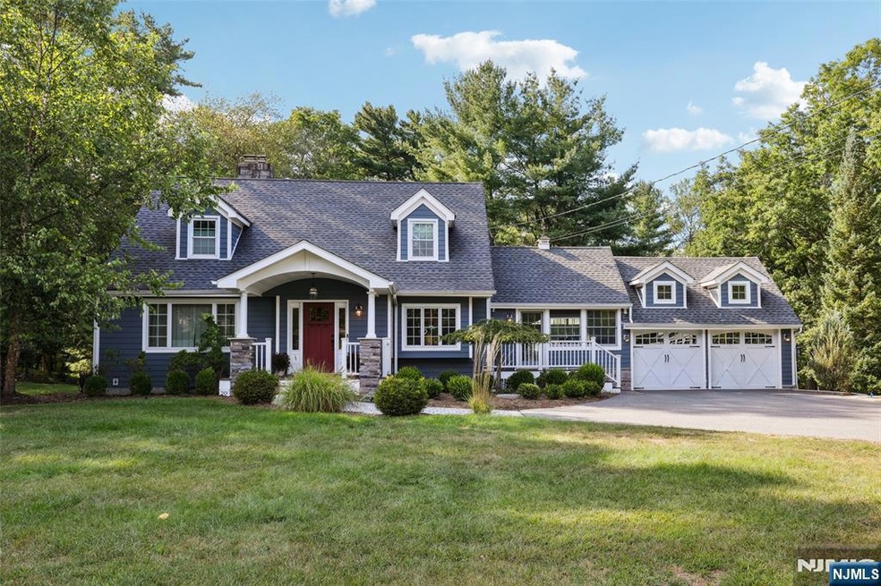
Turn-key in Wyckoff! This effortlessly charming colonial, modernized through renovations from 2014-2016, sits on a park-like 0.7-acre lot close to schools, town, and NYC-bound transit. Meticulously maintained inside and out, this 4-bedroom, 2.5-bath home features a beautifully updated kitchen with abundant natural light, Thermador appliances, and a bump-out expansion for an eat-in area. The first floor includes an entry foyer, a living room with fireplace, formal dining, family room/sunroom, a bedroom, full bath, and laundry. Elegant archways, detailed moldings, and a seamless blend of modern and traditional accents enhance the space. Upstairs, you'll find 3 sizable bedrooms and a full bath. The large unfinished basement is ready for your personal touch, with a partially completed full bathroom and walk-out access to an expansive covered patio. Enjoy a Trex deck (2016), perfect for entertaining, overlooking the expansive backyard and an enclosed breezeway leading to the 2-car garage. Combining character, thoughtful upgrades, and a prime location, this home offers comfort and convenience just moments from local amenities.
Last Agent to Sell the Property
Christie's International Real Estate Group-Ridgewood Listed on: 09/10/2025
| Date | Type | Sale Price | Title Company |
|---|---|---|---|
| Bargain Sale Deed | $1,125,000 | Carnegie Title | |
| Deed | $575,500 | -- |
| Date | Status | Loan Amount | Loan Type |
|---|---|---|---|
| Open | $806,000 | New Conventional | |
| Previous Owner | $460,400 | Purchase Money Mortgage |
| Date | Event | Price | List to Sale | Price per Sq Ft |
|---|---|---|---|---|
| 11/03/2025 11/03/25 | Sold | $1,125,000 | +12.6% | $577 / Sq Ft |
| 09/24/2025 09/24/25 | Pending | -- | -- | -- |
| 09/10/2025 09/10/25 | For Sale | $999,000 | -- | $513 / Sq Ft |
| Year | Tax Paid | Tax Assessment Tax Assessment Total Assessment is a certain percentage of the fair market value that is determined by local assessors to be the total taxable value of land and additions on the property. | Land | Improvement |
|---|---|---|---|---|
| 2025 | $13,724 | $703,800 | $469,300 | $234,500 |
| 2024 | $13,323 | $703,800 | $469,300 | $234,500 |
| 2023 | $12,964 | $703,800 | $469,300 | $234,500 |
| 2022 | $12,964 | $703,800 | $469,300 | $234,500 |
| 2021 | $13,048 | $703,800 | $469,300 | $234,500 |
| 2020 | $12,915 | $703,800 | $469,300 | $234,500 |
| 2019 | $12,739 | $703,800 | $469,300 | $234,500 |
| 2018 | $12,542 | $703,800 | $469,300 | $234,500 |
| 2017 | $12,387 | $703,800 | $469,300 | $234,500 |
| 2016 | $11,975 | $691,400 | $469,300 | $222,100 |
| 2015 | $11,844 | $691,400 | $469,300 | $222,100 |
| 2014 | $10,509 | $575,500 | $540,600 | $34,900 |
Seller's Agent in 2025
Christina Gibbons
Christie's Real Estate Northern NJ
(917) 837-8853
28 in this area
498 Total Sales
S
Seller Co-Listing Agent in 2025
Sarah Caprio
Christie's Real Estate Northern NJ
(323) 336-7272
8 in this area
36 Total Sales
H
Buyer's Agent in 2025
Hong Zhang
Keller Williams Village Square Realty
(551) 208-5007
1 in this area
12 Total Sales
Source: New Jersey MLS
MLS Number: 25032430
APN: 70-00203-0000-00005-01
Disclaimer: Certain information contained herein is derived from information provided by parties other than Homes.com. All information provided is deemed reliable, but is not guaranteed to be accurate and should be independently verified.
![]() The data relating to the real estate for sale on this web site comes in part from the Internet Data Exchange Program of the NJMLS. Real estate listings held by brokerage firms other than Ten-X are marked with the Internet Data Exchange logo and information about them includes the name of the listing brokers. Some properties listed with the participating brokers do not appear on this website at the request of the seller. Listings of brokers that do not participate in Internet Data Exchange do not appear on this website.
The data relating to the real estate for sale on this web site comes in part from the Internet Data Exchange Program of the NJMLS. Real estate listings held by brokerage firms other than Ten-X are marked with the Internet Data Exchange logo and information about them includes the name of the listing brokers. Some properties listed with the participating brokers do not appear on this website at the request of the seller. Listings of brokers that do not participate in Internet Data Exchange do not appear on this website.
All information deemed reliable but not guaranteed. Source: New Jersey Multiple Listing, Inc.
© 2026 New Jersey Multiple Listing Service Inc. All rights reserved.
Ask me questions while you tour the home.