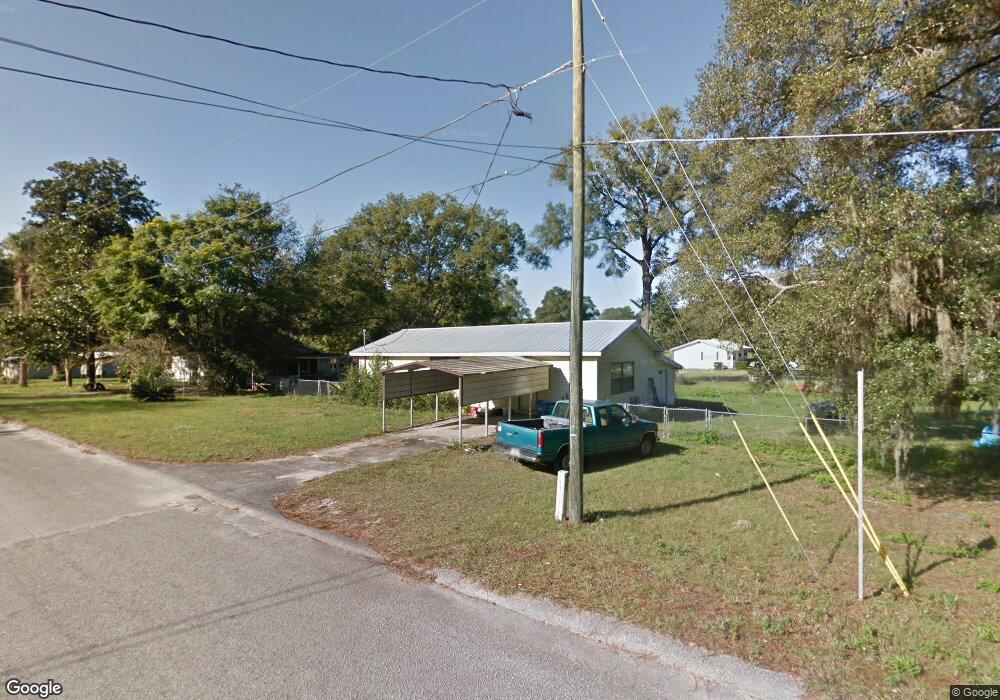
285 E Davis St de Leon Springs, FL 32130
DeLeon Springs NeighborhoodEstimated Value: $175,419 - $217,000
2
Beds
1
Bath
1,300
Sq Ft
$147/Sq Ft
Est. Value
About This Home
This home is located at 285 E Davis St, de Leon Springs, FL 32130 and is currently estimated at $190,855, approximately $146 per square foot. 285 E Davis St is a home located in Volusia County with nearby schools including Louise S. McInnis Elementary School and T. Dewitt Taylor Middle/High School.
Ownership History
Date
Name
Owned For
Owner Type
Purchase Details
Closed on
May 15, 1993
Bought by
Taylor Gerald G and Taylor Ann M
Current Estimated Value
Purchase Details
Closed on
Jul 15, 1988
Bought by
Taylor Gerald G and Taylor Ann M
Purchase Details
Closed on
Apr 15, 1988
Bought by
Taylor Gerald G and Taylor Ann M
Purchase Details
Closed on
Feb 15, 1988
Bought by
Taylor Gerald G and Taylor Ann M
Purchase Details
Closed on
May 15, 1985
Bought by
Taylor Gerald G and Taylor Ann M
Create a Home Valuation Report for This Property
The Home Valuation Report is an in-depth analysis detailing your home's value as well as a comparison with similar homes in the area
Home Values in the Area
Average Home Value in this Area
Purchase History
| Date | Buyer | Sale Price | Title Company |
|---|---|---|---|
| Taylor Gerald G | $100 | -- | |
| Taylor Gerald G | $45,000 | -- | |
| Taylor Gerald G | $34,900 | -- | |
| Taylor Gerald G | $100 | -- | |
| Taylor Gerald G | $30,000 | -- |
Source: Public Records
Tax History Compared to Growth
Tax History
| Year | Tax Paid | Tax Assessment Tax Assessment Total Assessment is a certain percentage of the fair market value that is determined by local assessors to be the total taxable value of land and additions on the property. | Land | Improvement |
|---|---|---|---|---|
| 2025 | $449 | $41,200 | -- | -- |
| 2024 | $449 | $40,039 | -- | -- |
| 2023 | $449 | $38,873 | $0 | $0 |
| 2022 | $421 | $37,741 | $0 | $0 |
| 2021 | $421 | $36,642 | $0 | $0 |
| 2020 | $412 | $36,136 | $0 | $0 |
| 2019 | $412 | $35,324 | $0 | $0 |
| 2018 | $395 | $34,665 | $0 | $0 |
| 2017 | $364 | $33,952 | $0 | $0 |
| 2016 | $445 | $33,254 | $0 | $0 |
| 2015 | $445 | $33,023 | $0 | $0 |
| 2014 | $439 | $32,761 | $0 | $0 |
Source: Public Records
Map
Nearby Homes
- 1909 S Farm Rd
- 1955 Hillcrest Oak Dr
- 0 Philadelphia Ave
- 1806 Glenwood Oaks Ln
- 30 High Ridge Ave
- 4155 N Us Hwy 17
- 0 Reynolds Rd Unit MFRO6225952
- 0 Reynolds Rd Unit MFRO6292104
- 0 Reynolds Rd Unit MFRO6225958
- 0 Reynolds Rd Unit 1219410
- 0 E Berlin St
- 0 North St
- 1056 Reynolds Rd
- 0 Garden St Unit MFRO6109460
- 235 Garden St
- 0 No Name Parcel 05163011380050 Unit V4910400
- 226 Garden St
- 2053 Bond Rd
- 237 Cortez Ave
- 5060 Audubon Ave
- 275 E Davis St
- 4738 Fairport Ave
- 290 E Davis St
- 266 E Davis St
- 261 E Davis St
- 4620 Fairport Ave
- 4741 Fairport Ave
- 4610 Fairport Ave
- 4620 Fairport Ave
- 4600 Fairport Ave
- 217 E Davis St
- 4650 Burrows St
- 4598 Fairport Ave
- 4605 Burrows St
- 211 E Davis St
- 4630 Burrows St
- 177 Citra St
- 4775 Fairport Ave
- 260 Citra St
- 242 Citra St