Estimated Value: $289,000 - $313,000
3
Beds
2
Baths
1,542
Sq Ft
$194/Sq Ft
Est. Value
About This Home
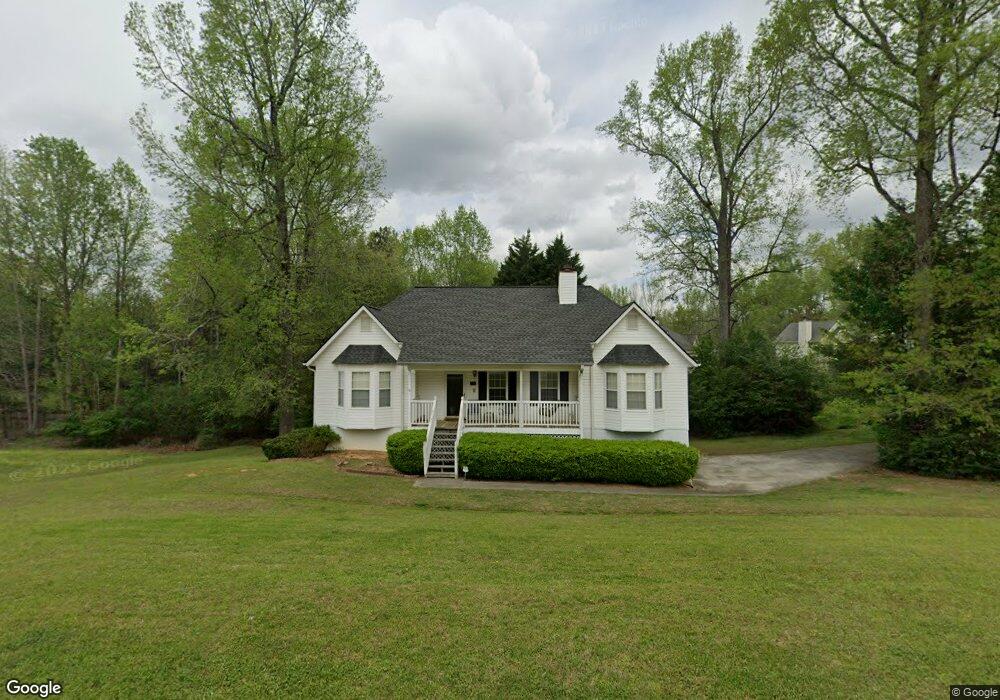
This home is located at 285 Harvest Way, Hiram, GA 30141 and is currently estimated at $298,760, approximately $193 per square foot. 285 Harvest Way is a home located in Paulding County with nearby schools including Sam D. Panter Elementary School, J. A. Dobbins Middle School, and Hiram High School.
Ownership History
Date
Name
Owned For
Owner Type
Purchase Details
Closed on
Oct 31, 2006
Sold by
Arsenault April
Bought by
Arsenault Stephen J
Current Estimated Value
Home Financials for this Owner
Home Financials are based on the most recent Mortgage that was taken out on this home.
Original Mortgage
$128,400
Outstanding Balance
$75,671
Interest Rate
6.33%
Mortgage Type
New Conventional
Estimated Equity
$223,089
Purchase Details
Closed on
Jan 18, 2006
Sold by
Baggett David B and Baggett Luvon J
Bought by
Arsenault Stephen and Arsenault April
Home Financials for this Owner
Home Financials are based on the most recent Mortgage that was taken out on this home.
Original Mortgage
$14,000
Interest Rate
6.22%
Mortgage Type
Unknown
Create a Home Valuation Report for This Property
The Home Valuation Report is an in-depth analysis detailing your home's value as well as a comparison with similar homes in the area
Home Values in the Area
Average Home Value in this Area
Purchase History
| Date | Buyer | Sale Price | Title Company |
|---|---|---|---|
| Arsenault Stephen J | -- | -- | |
| Arsenault Stephen | $140,000 | -- |
Source: Public Records
Mortgage History
| Date | Status | Borrower | Loan Amount |
|---|---|---|---|
| Open | Arsenault Stephen J | $128,400 | |
| Previous Owner | Arsenault Stephen | $14,000 | |
| Previous Owner | Arsenault Stephen | $112,000 |
Source: Public Records
Tax History Compared to Growth
Tax History
| Year | Tax Paid | Tax Assessment Tax Assessment Total Assessment is a certain percentage of the fair market value that is determined by local assessors to be the total taxable value of land and additions on the property. | Land | Improvement |
|---|---|---|---|---|
| 2024 | $2,925 | $117,588 | $12,000 | $105,588 |
| 2023 | $3,181 | $122,024 | $12,000 | $110,024 |
| 2022 | $2,314 | $88,772 | $12,000 | $76,772 |
| 2021 | $2,076 | $71,440 | $8,000 | $63,440 |
| 2020 | $1,966 | $66,188 | $8,000 | $58,188 |
| 2019 | $1,921 | $63,744 | $8,000 | $55,744 |
| 2018 | $1,707 | $56,668 | $8,000 | $48,668 |
| 2017 | $1,584 | $51,840 | $8,000 | $43,840 |
| 2016 | $1,480 | $48,940 | $8,000 | $40,940 |
| 2015 | $1,356 | $44,064 | $8,000 | $36,064 |
| 2014 | $1,162 | $36,816 | $8,000 | $28,816 |
| 2013 | -- | $25,000 | $8,000 | $17,000 |
Source: Public Records
Map
Nearby Homes
- 7131 Ridge Rd
- 2010 Laird Rd
- 6652 Ridge Rd
- 6994 Ridge Rd
- 232 Bethel Church Rd
- 115 Ashley Pointe Dr
- 493 Kyles Cir
- 178 Hunters Mill Dr
- 617 Kyles Cir
- 1616 Mcclung Rd
- 6488 Nebo Rd
- 51 White Path Dr
- 532 Poole Bridge Rd
- 245 London Ln
- 496 Hughes Rd
- 18 Hawk Dr
- 322 London Ln
- 4970 Nebo Rd
- 1379 Rich Davis Rd
- 7012 Nebo Rd
- 289 Harvest Way
- 195 Harvest Way
- 290 Harvest Way
- 222 Harvest Way
- 153 Harvest Way
- 252 Harvest Way
- 204 Harvest Way
- 125 Harvest Way
- 190 Harvest Way
- 256 Harvest Way
- 182 Fair Havens Dr
- 101 Harvest Way
- 276 Harvest Way
- 282 Harvest Way
- 268 Harvest Way
- 187 Fair Havens Dr
- 132 Harvest Way
- 69 Harvest Way
- 118 Harvest Way
- 96 Harvest Way