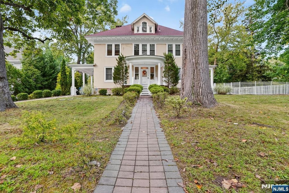
285 Maple St Englewood, NJ 07631
Estimated payment $13,011/month
Highlights
- In Ground Pool
- Corner Lot
- Gas Fireplace
- 34,182 Sq Ft lot
- En-Suite Primary Bedroom
About This Home
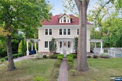
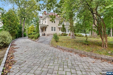
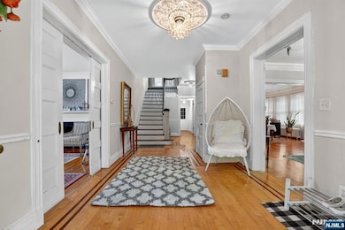
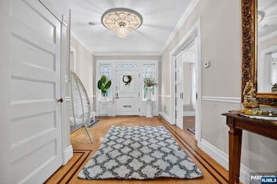
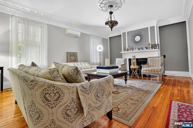
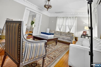
Welcome to 285 Maple Street, a marvelous 6 bed, 4.5 bath grand center-hall colonial located in the highly desired East Hill section of Englewood. Steeped in early 20th-century charm, this elegant home spans an impressive 4,533 square feet and sits on a lush 3/4-acre corner lot, offering both space and serenity in one of Bergen Countyâ€TMs most desirable neighborhoods. Classic stucco exterior and frame construction that reflect timeless craftsmanship. Three stories of living space, ideal for multi-generational living or expansive entertaining. Generous lot size with mature landscaping, and an in-ground swimming pool, perfect for outdoor gatherings or quiet reflection. Ductless AC system for comfort and convenience all year round. Gleaming hardwood floors, 2-car garage, a gorgeous 2nd level terrace, and an in-home elevator are just a few of the great features of this home. Whether you're drawn to its historic roots or its spacious layout, this home offers a rare blend of character and comfort in the heart of Englewood. Close proximity to all major highways/transportation, shops, restaurants, and places of worship. Easy commute to NYC. Book your showing today!
Home Details
Home Type
- Single Family
Est. Annual Taxes
- $32,862
Lot Details
- 0.78 Acre Lot
- Corner Lot
Interior Spaces
- Gas Fireplace
- Basement Fills Entire Space Under The House
Bedrooms and Bathrooms
- 6 Bedrooms
- En-Suite Primary Bedroom
Pool
- In Ground Pool
Utilities
- Ductless Heating Or Cooling System
- Heating System Uses Natural Gas
Listing and Financial Details
- Legal Lot and Block 7 / 3201
Map
Home Values in the Area
Average Home Value in this Area
Tax History
| Year | Tax Paid | Tax Assessment Tax Assessment Total Assessment is a certain percentage of the fair market value that is determined by local assessors to be the total taxable value of land and additions on the property. | Land | Improvement |
|---|---|---|---|---|
| 2025 | $32,863 | $1,069,400 | $681,000 | $388,400 |
| 2024 | $31,868 | $1,069,400 | $681,000 | $388,400 |
| 2023 | $31,537 | $1,069,400 | $681,000 | $388,400 |
| 2022 | $31,537 | $1,069,400 | $681,000 | $388,400 |
| 2021 | $30,241 | $1,069,400 | $681,000 | $388,400 |
| 2020 | $30,104 | $1,069,400 | $681,000 | $388,400 |
| 2019 | $29,826 | $1,069,400 | $681,000 | $388,400 |
| 2018 | $29,109 | $1,069,400 | $681,000 | $388,400 |
| 2017 | $28,243 | $1,069,400 | $681,000 | $388,400 |
| 2016 | $27,345 | $1,069,400 | $681,000 | $388,400 |
| 2015 | $27,109 | $1,069,400 | $681,000 | $388,400 |
| 2014 | $26,885 | $1,069,400 | $681,000 | $388,400 |
Property History
| Date | Event | Price | List to Sale | Price per Sq Ft |
|---|---|---|---|---|
| 09/12/2025 09/12/25 | For Sale | $1,999,900 | -- | -- |
Purchase History
| Date | Type | Sale Price | Title Company |
|---|---|---|---|
| Interfamily Deed Transfer | -- | None Available | |
| Deed | $1,100,000 | -- | |
| Deed | -- | -- |
Mortgage History
| Date | Status | Loan Amount | Loan Type |
|---|---|---|---|
| Open | $700,000 | No Value Available |
Source: New Jersey MLS
MLS Number: 25032823
APN: 15-03201-0000-00007
Disclaimer: Certain information contained herein is derived from information provided by parties other than Homes.com. All information provided is deemed reliable, but is not guaranteed to be accurate and should be independently verified.
![]() The data relating to the real estate for sale on this web site comes in part from the Internet Data Exchange Program of the NJMLS. Real estate listings held by brokerage firms other than Ten-X are marked with the Internet Data Exchange logo and information about them includes the name of the listing brokers. Some properties listed with the participating brokers do not appear on this website at the request of the seller. Listings of brokers that do not participate in Internet Data Exchange do not appear on this website.
The data relating to the real estate for sale on this web site comes in part from the Internet Data Exchange Program of the NJMLS. Real estate listings held by brokerage firms other than Ten-X are marked with the Internet Data Exchange logo and information about them includes the name of the listing brokers. Some properties listed with the participating brokers do not appear on this website at the request of the seller. Listings of brokers that do not participate in Internet Data Exchange do not appear on this website.
All information deemed reliable but not guaranteed. Source: New Jersey Multiple Listing, Inc.
© 2026 New Jersey Multiple Listing Service Inc. All rights reserved.
- 48 S Woodland St
- 167 Maple St
- 394 E Palisade Ave
- 285 Arch Rd
- 278 Fountain Rd
- 215 Brinckerhoff Ct
- 100 Huguenot Ave Unit 6B
- 109 Grand Ave
- 109 Grand Ave Unit 1A
- 109 Grand Ave Unit 4A
- 100 E Palisade Ave Unit B22
- 100 E Palisade Ave Unit A22
- 100 E Palisade Ave Unit A12
- 100 E Palisade Ave Unit B31
- 100 E Palisade Ave Unit D12
- 100 E Palisade Ave Unit A51
- 101 E Palisade Ave
- 315 Mary St
- 235 Walton St
- 420 Broad Ave
- 240 E Palisade Ave
- 394 E Palisade Ave
- 185 E Palisade Ave Unit C5B
- 100 A Unit 22
- 100 Huguenot Ave Unit 1B
- 100 Huguenot Ave Unit 6B
- 69 Chester Place Unit 5A
- 60 E Linden Ave
- 229 Allison Ct
- 100 E Palisade Ave Unit A12
- 158-166 Grand Ave
- 20 Grand Ave
- 24 E Forest Ave Unit 1
- 24 E Forest Ave
- 20 Grand Ave Unit 504
- 20 Grand Ave Unit 403
- 18 E Forest Ave Unit 2 FL
- 19 Florence St Unit 2
- 19 Florence St Unit 1
- 42 Bergen St

Ask me questions while you tour the home.